2020-01-25

Tramping (Hiking) in New Zealand #9: Bridgestone and Greenstone Backpacking day2-3

Greenstone and Caples Tracks

Type: Loop

Time Spent: 3 nights 4 days backpacking

Distance:  60 km (37- miles)

Elevation change:  4225 meters (approximately 6800 feet) 

<Day3>

Mid Caples Hut to middle to the forest near the junction of Caples track and Steel Creek track 

8 km (5 miles), 81 meters (266 feet) elevation gain


When we arrived at Mid Caples hut at 7 p.m. there were only 3 people at the hut. There was plenty of space. Two guys from Chicago, US. Father (Steve) and son (Dan). A lady from North Island, New Zealand (Julie). They were super nice. 


Then at 8 p.m. another hiker showed up. He is from Tasmania island, Australia (Gary). He was also friendly and chatty. 

Mid Caples hut

Since there were only 4 people at a hut with 24 bunks, everyone used 2 mattresses. It was luxurious. 


Gary snored a little, so I woke up when he snored, but it was fine. Compared to the hut we stayed in Italy during Tour du Mont Blanc, it was nothing. The Italy one was so terrible. 

The heavy rain warning was from 10 p.m., but the rain didn't come until 5 a.m. It started raining and got heavier when everyone woke up around 7:30 a.m. Ha. So all 4 people stayed at hut, kept fire going in the stove by putting coals continuously and chatted. I am not a social person, and in fact sometimes anti-social, but I found those people very nice and friendly and "safe". 

Julie is an avid hiker and she knew a lot about hiking places in New Zealand. Mr.N asked recommendation and got some ideas for the future trips. She is very nice, but her New Zealand English was hard to follow for me as a non-native English speaker. Even Mr.N had a hard time since she spoke very softly.
Gary came to New Zealand without a returning ticket. It seemed that Australians can go to New Zealand without returning tickets. Nice. He is retired, so he has time. He didn't rent a car and he hitchhiked to the trailhead. That's why he started hiking at 4 p.m. and arrived at the hut at 8 p.m. Gary has been to the U.S. 36 years ago and he hiked in Montana to Canada again that time by hitchhiking. He found out I did Mt.Whitney and asked me questions. He tried to hitch hike from Montana to Mt.Whitney, but it was too far to hitchhike that time. 

Steve's another son lives in Boston and we talked about Boston and New England a little bit. He has done "Great Walks" before and informed us basically Great Walk huts are same as this Mid Caples huts.  The price is $141 vs $15, though. 

It was still raining at noon, but Steve and Dan decided to go, because their plan is to go to Mckellar hut.  Soon Julie left for Green stone hut around 1 p.m.  Gary decided to stay at Mid Caples hut for another night. It's nice to have unlimited time. We left around 2 p.m. when the rain stopped. Since we had only 8 km to go with minimal elevation gain, we waited for rain to stop. Everyone was leaving and Gary said "I am attempted to hike, too" but Mr.N said, "You have unlimited time, no need to rush :)"

We left the hut at 2 p.m., so we soon saw people coming to the hut. We chatted that Gary would be happy by having chatting buddies. Actually those two people were second time we saw on the trail. We were hiking the same loop at the opposite direction. It was funny and nice. 

On the contrary of our optimism to find a freedom camp spot, it was hard to find a good place. It was very dense forest all the way and hard to find a flat dry spot. Most places had a lot of roots or moss on the ground. Our concern was it was going to be uphill to the saddle soon and if uphill started it would be unlikely to find a spot. Luckily after extensive search, we found a used campsite. It was very big site 70-80 meters away from trail and it seemed that trail crews used to camp there. We guessed that because a section of trail near the campsite was well maintained: actually all gravel was on the trail and trail edge was dug for the water to flow away from the trail. It must have been a long work, because the well maintained portion was quite long. The campsite has flat dry area with view. It was perfect, because there were falls on the mountain, which showed up only after rain. Also a lot of toutouwai visited us. They were very amusing and cute. 

Falls seen from the campsite

2020-01-23

Tramping (Hiking) in New Zealand #8: Bridgestone and Greenstone Backpacking day2

Greenstone and Caples Tracks

Type: Loop

Time Spent: 3 nights 4 days backpacking

Distance:  60 km (37- miles)

Elevation change:  4225 meters (approximately 6800 feet) 

<Day2>

Mckellar Hut to Mid Caples Hut via Greenstone Hut

37 km (23 miles), 396 meters (1300 feet) elevation gain

hedge hog

This day the hike started in the rain forest. While I was walking peacefully in the quiet forest....oops I almost stepped on the hedgehog! Camouflage. Cute! I stopped and took a picture. He seemed to be surprised as well and he slowly walked into the fern area in the forest. Maybe the trail is easier for them to walk. 

Rain Forest

Early in the morning, the rain forest is very wet and quiet. It was really peaceful. The wet trail didn't make any sound by stepping on, so it was completely quiet. Sometimes birds calls happily. 

toutouwai

Birds. New Zealand has a lot of native birds that can be seen only there. Between 4-6 a.m. is the birds' peak song time. It is literally non-stopping. Some has really high-pitch sounds, some are low, but all are cute songs. This is one of the fun parts of New Zealand forests. My favorite New Zealand bird is toutouwai (South island robin).  The picture is above. Although it is endemic, I was able to see them a lot. They really come close to humans. The reason why they come close is not because they want human food. They are looking for insects and after human step on the trail, usually insects came out. Toutouwai come close to big animals to get insects. They are very cute. Their songs are "toutoutoutoutou" I guess they were named toutouwai due to the songs. 


Bridge
Grass in the meadow

After a while we got out of the forest and saw nice open area. The meadow was pretty. We saw a guy in the distance fishing. Nice area. 

Then there was a swinging bridge. In New Zealand there are many swinging bridge. Some are more sturdy some are really built with minimal requirement. The bridge in the picture above is most frequently encountered bridge. As you might see the sign, it is one person at a time. It swings a lot when you cross. It is scary especially if it is windy. For me as a small person, it really unbalanced when wind comes from side. 

In the meadow area in the valley is actually a private land is there is stock. There are cows on the way at one point. Usually cows on the trail run away to the off-trail, from my experience in California. This time they did run away, but to the way we were going to. Grr. We had to get toward them. They didn't understand we were hiking on the trail. After a while finally cows went to the off-trail and we were able to proceed. We don't want to disturb stock, so it was hard!

Sheep in the field

Compared to cows, sheep was much more cautious and they immediately ran away when they saw a first sign of us in the distance. I took a picture in zoom, but only one picture was possible since sheep can run fast, surprisingly. They are cute.

The day started with clouds but soon it got better. On this day the original plan was just go to Greenstone hut. However, we arrived at the Greenstone hut very early like noon. Since the weather seemed okay, we proceeded more and intended to do freedom camp. Then we met a warden on the trail.
He was cutting some weeds to maintain the trail. He was taking care of three huts. Mckellar, Greenstone, and Mid Caples. Wow. AND he maintains trails. So much work. He was so nice. We gave him hut tickets for Mckellar huts for staying at the previous night. The huts tickets are reused. When we bought hut tickets at the visitor centre, the ranger told us some of the tickets were produced in 1996. Some are a little different design which were produced recently. When we gave the warden the old style tickets, he was very surprised. 

He said, "Wow these are very old. When did you get them?" 

Mr.N replied, "A few days ago at the visitor centre."
He answered, "Oh really."
Then he informed us that there is heavy rain warning that night. The warning was from 10 p.m. that day to 2 p.m. on the next day. So he recommended us to go to Mid Caples hut rather than freedom camp and sleep in  and start hiking late the next day. That made sense, so we continued hiking. In that situation the hike became very long: 37 km. 

He was the warden who was Japanese. I am very glad I saw him in person not only the hand-writing white board. 

Caples River

Despite the fact the heavy rain warning is released, the sky was blue and the view was so beautiful. The trail was along the Caples river. The green grass and mountains are over the river. The water color was greenish blue which was pretty. We saw some deer and some cows on the grass. Nobody was hiking in the section and it was quite nice. 

Chasm

A little before reaching the hut, we saw a chasm. Chasm is a deep and steep wall and the bottom narrow part the water was running. Usually you can see it from the top on the bridge. Because it is so narrow, the strength of water flow is tremendous. The sound of water echoes in the steep wall and says like "GGGGGOOOOOOO" I had never seen chasm anywhere else. Also the color of water was attractively pretty. Massive.

Then we reached the Mid Caples hut at 7 p.m. Loooooong day!

2020-01-21

Tramping (Hiking) in New Zealand #7: Bridgestone and Greenstone Backpacking day1

This day was started with fixing the flat tire problem. 

The Bridgestone opened at 8 a.m., so we arrived at 7:50 a.m. 

Mr.N: Are you open?
A guy: Yes.
Mr.N: We had a flat tire on the rental car.
A guy: Who was driving?
Mr.N: .....me.
A lady: I am recording.
A guy and a lady: Hahahahaha.
Mr.N: I think a new tire is needed.
A guy: You drive long with that.
Mr.N: .......probably.
A lady: they don't last long do they?
They are funny and nice.
New Zealanders are known for being very nice and friendly, and I found that the reputation is very true throughout the trip. 

The tire was kind of torn off, so we were sure we needed a new tire. The brach of Bridgestone near the Queenstown airport didn't have the tire for our car. We went to a nearby branch and got a new tire. 

Then we started a hike! Finally. 

Greenstone and Caples Tracks

Type: Loop

Time Spent: 3 nights 4 days backpacking

Distance:  60 km (37- miles)

Elevation change:  4225 meters (approximately 6800 feet) 

<Day1>
Trailhead (Divide) to Mckellar Hut
9.7 km (6 miles), 350 meter (1150 feet) elevation gain


Rain Forest
Kea

Although it was raining in the morning, but by the time we started hiking it was just a tiny drizzling. Besides, the first portion of the hike was in the rain forest, so rain was not an issue at all. Lucky. Rain forests after rain was shiny and pretty. It was so green. Trees, ferns, water falls, river. There is so much going on with a lot of water. 

Then we saw a noise. Whoa. Kea! Kea is a native New Zealand bird that is endangered. The bird was eating something from the branch. Inside of the wing is very colorful. The Kea continued knocking the tree. The Mauri name of the birds in New Zealand are interesting. For example, Kea's bird song is "ke-a". Another example is a bird like pipipipipi that songs pipipipipi. 

Lake Mckellar
Mckellar Hut

Then the Lake Mckellar appears. Since the blue sky came out, the lake looked nice blue reflecting it. The first day's destination was the end of the lake. After a couple of miles we arrived at Mckellar hut. Since it seemed the rain was gone, we were debating if we would stay at a hut or go beyond a little more for freedom camp. While we were thinking, the small rain came. So we decided to stay at the hut. 

Mckellar hut is located in a beautiful places in front of meadow. Over the meadow there is a tall cool mountains (the left picture). 

Mckellar hut consists of three rooms. A common room with tables, chairs, kitchen area, and stove with coals. There are two rooms of bunks beds. There is a room for a warden with stove, bunk beds, a desk and a chair, and radio to communicate with a visiter centre.  Near the kitchen area there is a white board and a warden wrote next three day weather forecast. Actually a warden takes care of three huts in the area, and he stayed at a different hut (a hiker at the hut told us). On the white board the warden's name was stated. I saw it and made me happy. The warden is Japanese. It was written as "Eiji Kitai, 北井栄治” his handwriting is clearly by Japanese, so I was sure he is from Japan, not Japanese New Zealander. 

Bunk Bed

Other hikers at the hut were quite international. French, German, Americans, and a hiker from Israel. Some people were doing te araroa (New Zealand's long trail of 3000 km! from north of North island to south of South island).
Bunk beds were nice and there are mattress there. However, Mr.N somehow moved a lot and mattress made squeaky noise all night. I couldn't sleep well.
Next day we got up at 5 a.m. and started hiking at 7 a.m. 

2020-01-19

Tramping (Hiking) in New Zealand #6 IZZY and FLAT TIRE!!!

After hikes in Aoraki/Mount Cook National Park, we headed for the next backpacking. 

Our plan was to backpack 3 night/4 days in dirt track. To check the conditions and get hut tickets, first we went to DOC visitor center in the town. The guy at DOC was very knowledgeable and gave us a lot of information.
Before heading for the trailhead, we first needed to get food and snack for backpacking. So we went to New World Market. New World Market is a grocery store chain similar to Safeway or Market Basket in the U.S.

At the entrance of New World Market in Queenstown, I saw a cute cat!!!!! Her name is "Izzy Cat" Izzy is the first name, Cat is the last name. Izzy is a supermarket cat in Queenstown. She used to be wild, but over the years, she got tamed and now an unofficial employee of New World Market. There is an article posted near the Izzy's shelter and cat tower. You can read the article, "Izzy the supermarket cat" here.  Also there is Izzy's Facebook page even!

Izzy

When I approached the entrance, Izzy was sitting under the bench (you can see the metal bench in the left picture). I sat near Izzy and said, "come here!" and Izzy came to me. She looks happy by being pet. Cute!
Then she sat on the bed and started kneeling.  If I lived in Queenstown, I would come New World every day!!!!!!

I think that Izzy is definitely contributing to the New World's business. A lot of locals love Izzy and people come to see her. Izzy's shelter which has name tag saying "IZZY" was donate by a doting customer. Izzy also has a blanket which also has "IZZY" tag.  Izzy is one of highlights of this trip for sure. 

<Conversation after discussion what the highlights of the trip>

Mr.N: if a cat is a highlight, no need to fly 14 hours. 

K: No. It has to be Izzy. Period.

Well, Okay. So, back to hiking blog. 

After filled our backpacks with snacks from New World Market, we went to the trailhead of Dart Track in Mount Aspiring National Park. The tricky thing of this part is it is a dirt road to the Dart track. This dirt road has small water flowing portion to let water from rain in the mountain go. If it is no rain it is just a small hollow every 10 meters. However, if there is rain during our backpacking, our sedan car might not be able to go through. That means we might be stuck at the parking lot at the trailhead. The ranger at DOC center said 4WD is recommended but not required. Anyway we tried to drive to the trailhead. However, maybe at the third hollow, already it was obvious sedan car can't go through to the trailhead. Being that situation, we decided to go backpacking in the backpack area. Then we started heading back to the paved road portion. On the half way to the pave road, three Asian ladies, clearly Chinese, were standing. One lady tried to talk to us, so we stopped and rolled down the window. The lady was on the right of the car, so talked to the driver (Driving seat is on the right in New Zealand, so is Japan), Mr.N. 

She talked to Mr.N, "We are wondering if it is possible to get a lift to the pave road, 7 km away."
She explained, "Our rental car is not allowed to drive dirt road."
Mr.N said, "Yes we can give you a ride."
Then she saw my face and, "中国語中国語中国語 (Chinese)"
Mr.N: ........... (silence)
Me : ........... (silence)
Me inside: I am not Chinese....I AM NOT CHINESE!!!
Mr.N: She doesn't speak Chinese.

Basically they parked their rented car at the end of pave road and started walking on the dirt road, because their rental company didn't allow renters to drive on a dirt road. They walked 7 km and got tired and no energy to walk back. Apparently they wore normal clothes not hiking wears. Also it seemed they didn't have any water. Because we had a lot of stuff on the back seat, we asked them to hold stuff while they sit in the car. Only one of the three people could speak English. Even that when Mr.N talked to them in English, she didn't understand at all. 

It reminded me of the early days in the U.S. Actually listening is very important. I think that listening skill is more important than speaking. If you don't understand a question, you can't answer, which means there is not even an opportunity to speak. If you don't understand group chat, you don't know what to speak. If you don't follow the conversation, you feel left out. 

While I was thinking about that, we reached at their car. It was 4 WD. Hahaha. Our car was a sedan driving 4WD recommended road.
Then we started driving on the pave road, and got this.

Flat Tire
 Flat tire. 

How many times did I get flat tires during adventures?

1. Yosemite
2. Trinity Alps
3. Death Valley
4. Death Valley (2nd)
5. Big Island, Hawaii
6. This. New Zealand

Now I know how to replace a flat tire with a donut. OK. We went to Queenstown airport and went to a rental car company. The company person told us to go to Bridgestone tomorrow morning since it was already 6 p.m.  

River at the campground

We searched a free camping area run by DOC and camped there. It was a pretty spot. The camping area is right near the beautiful river. 

While we were chilling, 2 rafting person came from upstream and finished at the campground. Wow. Looks adventurous.
Only complaint here was the toilet was stinky! In New Zealand the term toilet is used for the restroom/bathroom in the U.S. I felt good, because the term toilet is used in Japan, too. Another good thing I felt home was left side traffic with driving wheel at the right side. It is same as Japan and I felt so good with that. 


2020-01-17

Tramping (Hiking) in New Zealand #5 Aoraki Mt.Cook National Park : Red Tarns and Off-Trail Beyond, Tasman Glacier Valley Lookout

Red Tarns Track (and beyond)

Type: Out and back

Distance: 3.6 km (2.2 miles) (more if go beyond)

Elevation change: 335 meters (approximately 1099 feet) (more if go beyond)


Optional: you can continue hiking up off-trail

Red Tarns

In the afternoon, we hiked to Red Tarns. This track start at Mount Cook Village. This Village has some hotels and cottages. No campers can stay these and still can hike. 

On this track, again, there are a log of stairs to the tarns. Literally there are continuous steps. The hike starts with crossing river with bridge and immediately the first set of stairs show up. Then, stairs stairs stairs. Very soon the forest part finished and you will go beyond the bush line. There are continuous gorgeous mountain views. Ah. So. Pretty. I felt I was paid off way beyond by coming all the way to New Zealand. Also it was lucky to have two consecutive perfect sunny days in Mount Cook/Aoraki National Park. 

Only thing I realized what I need to be careful on a sunny day in New Zealand is....UV!!!

Usually I don't get a sign of sunburn, such as red skin. I just get tanned color of skin on the next day of hike if I don't put enough sunscreen. On this day I found that my arm where I forgot to put sunscreen was becoming red. Wow. UV is extremely strong in NZ. I heard that there are holes somewhere at south on the ozone layer (near antarctica), and it affects NZ (however, I don't know very well). From this day I put sunscreen everywhere frequently. 

Above Red Tarn

The original destination was Red Tarns, but we saw a hiker going up further from Red Tarns. Not clear, but there was an abandoned or some used trail was seen from Red Tarns. I got interested. I suggested Mr.N going there and he said no. After a break at Red Tarns, I suggested again and Mr.N agreed on going. It is not an official track, but it seems some hardcore people go. If you are good at finding a trail, you will see the track on the right picture. During we climb this portion, a group of 7-8 was descending. It was obviously a guided group: a guide, probably New Zealand local guy, and probably international hikers (they seemed late 60s or 70s: impressive doing unofficial track). 

Mr.N asked a guide guy, "Do you know where this trail go?"
The guy kindly answered, "It doesn't really go anywhere, most people go to tarns at the top, it is really pretty there."
Mr.N thanked, "Great, thank you very much."
The guy replied, "No worries."
He was very friendly and nice. All NZ people said, "no worries" in response to "thank you". During the trip 100%, no exception, people said it.
It is obviously NZ English and I loved it. 

AND....above Red Tarn was amazing. Both me and Mr.N's one of the highlights of the entire NZ trip is this region. It is very secluded, peaceful, and beautiful. 

First, There was a view of Tasman Glacier Valley. One of the greatest spots to see in Mount Cook/Aoraki National park. From that point, nobody was there and we were able to see the view very peacefully. I took off shoes and enjoyed the view by laying down on the grass. Comfy. Priceless!

Tasman Glacier Valley

Pretty Tarn

Also there are many tarns in this meadow area. Snow and glacier mountains over the numerous tarns in the meadow was really pretty.
After we enjoyed the view we came down to the Mount Cook Village and and headed for the final small hike of the day. It is nice to have a long daylight. The sunrise is 5:20 a.m, and the sunset is 9:20 p.m. in December in NZ, meaning a lot of time for hiking. 

Tasman Glacier Lookout

Type: Out and back

Distance: 1-2 km (1.6-3.2 miles) 

Elevation change: 100 meters (approximately 328 feet)


This is a short hike without minimal elevation change. It is very popular for all level of hikers. We came here around 5 p.m., so it was not crowded. Probably normal hikers who don't camp but stay at hotel are already headed out for dinners. 

Tasman Glacier

In this hike now we saw Tasman Glacier Valley close. From the basin above red tarn, we looked way down the Tasman Glacier Valley. It is a different angle. Glacier is massive and cool.  The lake color is grayish because it is very close to glacier. 

Still immense, but the glacier size is rapidly shrinking due to global warming. The place I took picture was all covered with ice before. Sad. The future of NZ glaciers are unknown, but they are shrinking way faster than expected. 

Ball Hut Route (CLOSED: as of 2019 December)

Type: Out and back

Distance: 18 km  (11.2 miles) 

Elevation change: 120 meters (approximately 394 feet)

Leaving Aoraki
Free campsite with full moon
This is the track along the Tasman Lake toward the glacier. We had planned to do as a day hike, but due to 2019 December storm, the track was washed out. Due to this situation, we did all the attractive hikes in Mount Cook/Aoraki in 2 days.We decided to leave this area in the evening and camped in the free camping area from 1 hour away from the Aoraki. Driving near Aoraki National Park was pretty. These are very New Zealand-ish view. Beautiful mountains and pretty meadow with sheep. Cute sheep were resting after dinner. Lucky sheep. 
On this day we luckily found free camping area. Even after sunset around 9:20 p.m., full moon was there and still we didn't need to use headlamps at all. 

2020-01-15

Tramping (Hiking) in New Zealand #4 Aoraki Mt.Cook National Park : Sealy Tarns and Kea Point

Sealy Tarn Track

Type: Out and back

Distance: 4.5 km (2.8 miles)

Elevation change: 520 meters (approximately 1706 feet) 

Optional: you can continue hiking up to the Mueller Hut


Kea Point Track

Type: Out and back

Distance: 2.8 km (1.7 miles)

Elevation change: 200 meters (approximately 656 feet) 

Comment: Same starting point from Sealy Tarn Track, and there is junction. One to Sealy Tarn and Mueller Hut, the other is to Kea Point

Everyday we got up at at 5 a.m. and started activity at 7 a.m. All the way we came to New Zealand. Why not maximize the time of activity!? 

On the second day of Aoraki/Mt.Cook National park, we started hiking to Sealy Tarns. Tarn is a word used in NZ (seems like). I believe I had never heard it in the wilderness in the U.S., but maybe only me who didn't notice it, because I am not a native English speaker. Tarns are used for indicating small lakes or ponds in NZ. For me Sealy Tarns sounded like a silly tarn, so it was funny. On the way to Sealy Tarn is steep, but there is continuous view, which helped me to blow the tiredness away. Looking back the way I had climbed and saw the view of the picture below. Parking looked already small with tiny cars. Vast valley with steep cool mountains, once all covered with glaciers. Outstanding!

On the way to Sealy Tarn

Steps

The track has a lot of (read: A LOT OF) steps: it seems NZ tracks like to provide steps if it is well maintained, and popular tracks. These steps reminded me of our hiking friend, Mr.S2. He used to have knee issues and had to go slow on the steep trail with steps in Grand Canyon. I would not recommend this for people with knee issues. 

As I went up, I was able to see the Hooker Lake and Mount Cook/Aoraki in a different angle from a hike of a previous day. Besides, there is a good view on the left side of mountains. Since we started early and beat the crowd, it was nice to stare at that breathtaking view in a quiet setting. 

Beautiful Hooker Lake

From the Sealy Tarn, the trail continues to the Mueller hut. The trail until Sealy Tarn is track, after that it will be a route (how to call trail in NZ is described in the NZ trip blog #1). We tried tramping up some on the route, but as a ranger had told us before, there was a lot of snow and it seemed crampons and ice axe were needed. Also the rangers warned us there was avalanche risk, so we decided to turn around after 1 km of tramping after Sealy Tarn. Some people went to the Mueller hut really early morning and coming back to the spot we were taking a break. Mr.N asked how was the track and a guy said the snow is until thigh level. Also he mentioned it would be dangerous in the daytime. It was already a great view there, so we were satisfied. Later I noticed that I left my sitting pad at the break point. Sigh. It is better than other more important thing, though. The pad was only $14. This 2019 December there was much more snow on the way to the Mueller hut. Actually we had planned backpacking to the muller hut and camp there overnight, but we decided to skip it. It is wise to think that better safe than sorry, due to avalanche risks. 

At Key Point

After we came down from Sealy Tarn, we went to Kea Point. This is recommended for people with intention to have a nice short hike without much elevation gain. Although it is short, it is a spectacular hike. From Kea Point, Mount Sefton can be seen very well. It is gorgeous. It is so massive and I felt like I was sucked from its immense glacier. Reflecting the sunshine with blue sky, the blue glacier even looked more blue. 

There is a sign at Key Point how people figured out the way to the summit of Mount Sefton. If I remember correctly, first people climbed from the side in the picture, but later other side found be easier. 

After these two hikes in the a.m. we had lunch near the trailhead and headed for the next hike. 

2020-01-13

Tramping (Hiking) in New Zealand #3 Aoraki Mt.Cook National Park : Hooker Valley Track

The first hike in New Zealand was Hooker Valley Track.

Hooker Valley Track

Type: Out and back

Distance: 11 km (6.8 miles) to the edge of Hooker Lake

Elevation change: 120 meters (approximately 400 feet) 

Optional: you can go up the ridge along the Hooker Lake, which is categorized Route

This is the most popular hike in Mt.Cook/Aoraki National Park. It is very scenic, easy walk on the extremely well maintained track. Trail is crowded in the afternoon and early evening. 

Hooker Lake
Aoraki/Mt.Cook


The trek is amazing. It had non-stopping view and the destination is the Hooker Lake. Mt.Cook can be seen over the lake. Aoraki/Mt.Cook is sharp at the top and seems looking down visitors from high point. It is a really cool and handsome mountain. 

Looking down Hooker Lake

As you can see in the left two pictures, it is not only Aoraki. The lake is surrounded by glaciers and snow-capped mountains. Sometimes sun shines on the glaciers, on the slope of mountains and sometimes clouds roll into the mountains. Any single moment is beautiful. Along the way all the change can be seen. I was continuously moved by the view, so the way to the lake was quick. Most people stop when they reach the lake. We didn't. We continued going up to the ridge along the lake. The trail is now called "Route" (please refer the Tramping in New Zealand #1 entry for the naming of trail kind). This portion was really nice, because nobody was on the route. We took time to walk on the ridge looking ahead and back and down at lake. All the directions were breathtaking. We sat down on rocks to appreciate the views and had some quiet time. Priceless.

Camping
A lot of bunnies

Only downside of this trail is crowded. I did it during the peak time of the day, so it was hard to pass some people who are standing on the trail or walking much slower than me. Usually when I go strenuous trails I don't pass hikers much, but this Hooker Valley track has all kinds of people who seem never hiked before. Most surprising outfit I saw was red floral dress with shiny sandals, and an umbrella (it was sunny... not for the rain but for avoiding sunshine). Now you can see what kind of track this is. 

Other spots along the trail which was worth seeing was memorial tower made by rocks for people who passed away during climbing Aoraki. Another one was a famous rock where the first woman who climbed Aoraki took a picture. It was 1910! In that era there must not be so much advanced tools to climb. I respect Freda du Faur. 

I think this Hooker Valley hike is a must if you stay in Aoraki National Park. It doesn't take long. We took around 3-4 hours including "route" portion. 

We camped two nights at White Horse Hill campground located in the Aoraki Naitonal Park, just at the trailhead of Hooker Valley Track. We had a sedan car and camped in a tent throughout the trip. Tent people are actually minority in New Zealand. Most people love camper vans. Several companies are especially popular: Jucy, Autobarn, Britz. It is interesting. During 3.5 weeks in New Zealand, I saw at least 200 Jucy vans, 100 Britz, and 100 Autobarn. I have never stayed in a camper van, but probably I prefer to stay in a tent.

At this campground, there are many bunnies. They are cute. In New Zealand, originally there was no mammals on the land (except for sea mammals like seals), so bunnies are not native. Without predators, bunnies seem to expand a lot here. They love grass here. The cost to camp here is a little higher side. $13/person per night, but it is inside the National park and very convenient. Besides, there is no fee to enter National Park, which is different from American National Park. 

2020-01-11

Tramping (Hiking) in New Zealand #2

The first time I heard about hiking in New Zealand was about 7-8 years ago. My buddy at work showed me a picture of her mother hiking in New Zealand. It was in the beautiful area. I still remember our sarcastic conversation. 

My buddy Ms.M was showing me a picture and said, "My mom is hiking in New Zealand."

I replied, "Wow, it is very pretty! Nice."

Ms.M said, "It is miserable, huh?"

We were doing experiments in the lab and so jealous. 

Since then New Zealand is one of my hiking destinations on the bucket list.

For people who live on the northern hemisphere like U.S.A, New Zealand is a great destination in Christmas holiday season. You can escape winter by going to New Zealand where December is summer. Actually we tried to go to New Zealand in December 2018 first, but the flight ticket was very expensive. In February 2019, we found a reasonable price ticket for December 2019 trip and booked. After 10 month of waiting, the trip started. 

It is a long way to go there from Boston. 

On the way to go there: Boston to Houston, Houston to Auckland, Auckland to Christchurch. 

On the way back: Christchurch to Auckland, Auckland to San Francisco, San Francisco to Boston. 

19 hours of flying time + custom + waiting time at airport=LONG

Although the flight was long, especially US to NZ portion, it was not boring. Air New Zealand provides very good service! I saw many movies on the plane... I enjoyed Hustlers, The Sound Of Silence, some NZ short movies. 

Surprising fact on Air New Zealand was that there are some Les Mills in flight stretch videos. Les Mills is a New Zealand company which provides a variety of fitness/exercise programs all over the world. I am a big fan of BODYPUMP, one of their programs. I occasionally review BODYPUMP versions in this blog. I enjoyed a lot about their in-flight stretch videos. 

Food is good (I have to say Japanese airlines' food are better) and you can order complimentary drinks including New Zealand wine from touch panel as much as you can. I tried both red and white New Zealand wine. They were really good. 

Then finally we arrived at Christchurch on the south island of New Zealand. One thing you need to keep in mind to go to New Zealand with camping gears is that there is biosecurity check at airport. It is required to report what you brought and where you have been used with them, such as tents, hiking boots, etc. Our tent went into the check line. They opened and inspected if there is something stick to the tents that could impact the nature in New Zealand. The inspection was around 10 minutes and it was fine. My guess is as long as clean and free of dirt or small insects, it is okay. 

We rented a car at Dollar, then went to grocery stores to get camping food. Luckily Christchurch has a Japanese grocery store, we had found this online in advance, so we didn't need to bring so much staff from Boston. We got ramen, udon, soba, pasta sauce, anpan, Japanese snacks there. We bought the rest of camping food at New World market, which is similar type of store to Safeway/Market Basket in the U.S. 

Then we searched for a cafe/restaurant to have food. 

food I got
Coffee

On the plane Mr.N told me that New Zealand has a different meal style. Breakfast (in the morning, same as the U.S.), dinner (around noon, equivalent to lunch in the U.S.), then tea, then supper (equivalent to dinner in the U.S.). I thought, "Huh, it is interesting."


Then, the very first restaurant I saw in New Zealand has this big sign at front.
Lunch: 11 a.m. -2 p.m.
Dinner: 5-9 p.m.

I said, "Look at that!!! Mr.N!"
Mr.N was, "........."
Mr.N continued, "Maybe it is different now from when I was in New Zealand during student exchange 17 years ago."
I was, ".....OK"

We went to a different cafe and we had coffee and food. It was delicious! Definitely tastier than most restaurants in the U.S. with the same price. 

Campground

In the evening we camped near Christchurch. In New Zealand there are many DOC campsites, and many private campsites. Usually there is a box to put money, first-come first-served. The one we stayed was the private one (Rakaia huts campground), $8 per person per night. Showers are available for $1 coin. 

We used Wikicamp App to find a campground nearby or on the way to the next destination. There are a bunch of campgrounds in New Zealand. Some are free, but most are $8 (without shower), $12 (with shower) per person per night. No bookings are required. It is good for flexible trips. 

The next day we started hiking. 

To be continued...

2020-01-09

Tramping (Hiking) in New Zealand #1

Tramping in New Zealand is amazing.

Tramping is a word used in New Zealand. Tramping means hiking, backpacking, walking in the nature.

First blog entry of our New Zealand trip, I describe the features of tramping in New Zealand.

Trampers in New Zealand can see a variety of scenery: glaciers, snow-capped mountains, dry ridges, vast fields of grasses, rivers, lakes, ocean, volcanoes, rain forests, deep green forests, etc. It is more than people expect. 

Trails are generally challenging due to its rocky terrain with many small ups and down everywhere and of course big ups and downs for high mountains. It is tough but at the same time it is quite rewarding. 

Good conditioned and well maintained trails are called tracks, and more challenging and less maintained ones are called routes. However, normal fit hikers have usually no problems tramping on routes. I did a lot of tramping on the routes. 

Trails in New Zealand are very well organized and information can be easily found. Department of Conservation (DOC) regulates and maintains all the trails. Each town and each National parks has DOC visitor centre and people there know very well about trails and really nice to visitors. It is important to check out those DOC visitor centres before tramping, because there are frequent trail closure in New Zealand. 

Trail sign
Trail sign

Trails are well marked. As you can see in the left picture, there is an orange arrow sign on the tree. In the picture trail is going to turn right, the arrow is pointing right. Above bush line (in New Zealand a tree line is called a bush line), orange poles are used as you can see in the right picture. It is a bush line in the right picture. For the first arrow sign to enter the forest, the arrow sign is a little bigger than usual arrow sign. It is well thought.

The New Zealand weather pattern is closely related to trail closure/open. In general, New Zealand gets a lot of rain, especially on the west coast. That causes land slides. Indeed a week before our arrival, 200 mm of rain (nearly 8 inches) per day continued 7 consecutive days on the west coast. This caused land slides and led to 20 days of road closure, which is a critical access road to the west. Also this large amount of rain resulted in many track closure including our planned hikes. We had a booking for the hut on the closed trail, so we went to DOC centre and got a refund. 
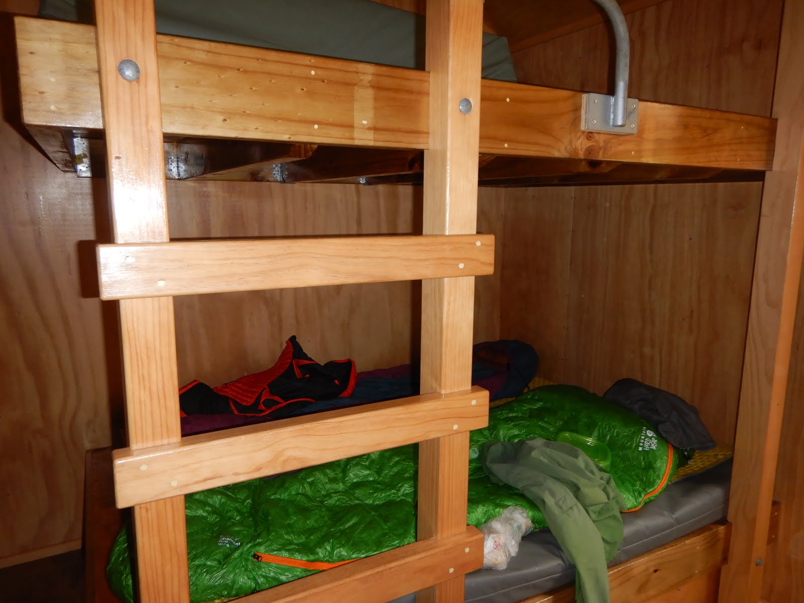
Heating at a hut

Bunk bed a hut
Huts culture is well established in New Zealand. There are a number of huts along the trail or sometimes off-trails. Huts for "Great Walks" (mentioning later) are very expensive: average $135 per adult, half the price for NZ residents. Great Walks huts are required to book in advance, usually 6 months in advance (!). Serviced huts are $15 per adult per night. Serviced huts usually have a warden during peak seasons, and there are heating (wardens provide coals/logs), kitchen area, sink, water (need to boil or treat), toilet ("long drop"), bunks with mattress. You can buy hut tickets at visitor centres. One ticket is $5. So for example you will give a warden 3 tickets for staying at a serviced hut. For a standard hut, there is a box to put a ticket in. 

As I mentioned above, Great Walks are featured hikes certified by DOC. In total there are 10 Great Walks (3 on North island, and 6 on South island, 1 on Stewart Island /Rakiura). Mostly 3-5 days hike per Great Walks, and because freedom camp (camping on the random place like do in Sierra) are not permitted along Great Walks, you need to stay at huts or camping area in front of huts. Most of Great Walks are not a loop, so you need to arrange a car shuttle, which is expensive too. I am sure those Great Walks are great, but personally the hut costs (and even camping in front of huts) are rip-off. Great Walk huts provide mattress, and basic kitchen area, no food, and $135?? Wow. European huts provide dinner and breakfast and shower and bunk bed for $70-80. Humm.  There are many many great walks (non-capital) in New Zealand, so we did a number of amazing great walks outside of "Great Walks".