2019-06-29

Backpacking in Adirondack, New York

We went backpacking in upstate New York for the first time. 

We did a 15.2 mile loop in Adirondack. This covers Bear Den Mountain, Dial Mountain, Nippletop, Indianhead, Beaver Meadow Falls, and Wedge Brook Cascades. 

Leaving Boston at 6 a.m. was early enough, I thought. It was not at all. The parking lot was full. The side of highway was all taken wherever it is allowed to park. The next possible parking spot was 0.6 mile away from the trailhead. Wow. Adirondack is very popular. I didn't know that.

So the hike started by walking on the State highway73. Then, there is another paved road walking. This is a little weird. To go to the forest area, hikers need to pass some private lands including houses and gulf courses. This area is paved, but only vehicles belonged to the land owners can drive. This system started this year (2019). According to the internet, cars are allowed to park along this road until the actual trailhead. After a paved road walk finally actual trailhead showed up!

Climbing up via Leach trail was surprisingly peaceful. I had expected there would have been hikers everywhere considering the numbers of cars, however, most people went hiking other easier trails. I definitely like quiet trails, so it was good. 

The first view was after 2 mile hike. It was nice to have some views periodically. Then the next view point was Bear Den Mountain. This mountain top was in the forest without view. However, there is a campsite with obvious fire ring. It looks not bad to camp quietly in the forest. I looked around bear dens, but I was not sure. I am curious about bear dens.

Dial Mountain

Then next view point was Dial Mountain. Although it was windy, the view was nice. How green it is. The green is still new after long long winter, so new leaves are still light green. Now it is a mixture of light an dark green. I like the light green season. It is more pop and casual.

Here we saw two parties. Both were doing the entire loop in a day. They are from state of New York, so they could start earlier than us. Including the two groups, most hikers seemed to do the loop the opposite way we did, probably because people want to the steepest portion as uphill but not downhill. The reason we chose the direction differently was to have a campsite a little past the half way of the loop and after all the uphill of loop. In that way we can relax more.

Grrr

After Dial Mountains, the trail got muddier and muddier. By the time I reached the Nippletop, my shoes became the color of mud, as left picture. 

Then finally we arrived the top of Nippletop. The name of this peak is weird...to be honest, but the view was nice. Both clouds and mountains are continuous like ocean wave. This kind of clouds are often seen in Northeast of US but I don't recall in the west. 

I ate chocolate and some crackers. I always like to have snack at the top of mountain.

Nippletop

After Nippletop, downhill is very steep. This is the steepest slope of this loop. The slope is about 40-43%. It is still less steep than Clear Creek Trail of Mt Shasta, but still! Besides, the trails in the northeast US are rocky. I understand why dogs are not allowed here. Doggies will have to whining a lot on the steep rocky trails. 

After descending 1000 feet, there are official backpacking campsites near the pond. It is great that Adirondack offers free campsites. Also it is not competitive. The two of them were both available. This time we brought cup-noodles for dinner. It was cup-udon. I love Japanese style dinner for camping. This cup udon was much better than I had expected. Camp dinner is the best. 

At the campsite, sounds of birds and frogs were nice. Relaxing tones. With sounds, I enjoyed looking at ponds, trees, and eating udon and chocolate. 

Indianhead

Next day we descended a lot. I realized how much we had ascended a day before. Day2's viewpoint was Indian head. Two lakes are visible: upper and lower. It is great to see such canyon from the higher standpoint. We took a rest here. This is one of the most popular dayhike destinations in the area. Actually almost all people at the parking lot of the trailhead go here. One thing I was surprised was that more than half or the hikers at the Indian head were French Canadian. Working at French company, I can recognize French in a second. Wow. Some people were talking about being from Montreal. It seems Quebec people are very outdoorsy. 

Ausable River

After Indianhead, we walked down the West river trail. It is literally along the river (the left picture). It is nice to walk hearing water sound. It is chilling. Again on this trail I saw several French Canadians. 

One point I saw one deer made noise and ran away. Maybe a little scared? But cute!


Beaver Meadow Falls
Wedge Brook Cascades


not named


The amount of water is actually impressive. Indeed along the way, we saw three falls. Beaver Meadow falls, falls with no name, and Wedge Brook Cascades. 

Although it was far to go to Adirondack compared to White mountains in New Hampshire, having a variety of places is nice. Once in a while definitely will come back to Adirondack. 

After being full of nature for 2 days, we ended the trip by eating artificial and unhealthy KFC.

2019-06-27

Rocky Mountain National Park Day3

Mills Lake

 日本語は英語の後にあります。

On the last day in Rocky Mountain National Park, we did a day hike. We started at Bear Lake and hiked up the Glacier Gorge. First lake we saw was Mills Lake. Under sun, it was pretty. It is only a couples of mile to Mills lake, there are some local day hikers were there. Seeing that, I thought that it might be fun living in Colorado. There are so many great hiking area in CO.  

Then next lake we reached was Black lake. It is blue/greenish color of lake. It is beautiful. After more than 4 miles, not many people here. It is very quiet and nice. We ate cheese and crackers. While eating, I was thinking why this lake is called black lake, because it is so blue. I didn't know that I would get answer one hour later.
Black Lake

After climbing the hill for 30 minutes, I looked back to see the view. Then I realized Black lake is now looks black! At least much darker color than I saw at the lake. Wow. That's why it is called black lake. The color might be different what time of the day and where you see the lake. 

Trail from black lake to the next valley was faint, but it was all paied off. The valley above black lake was so beautiful. It was also geologically interesting. These two pictures below have interesting shape of rocks.

Lastly the big bonus near the trailhead was double rainbow. It is pretty rare to see such two big rainbows.

I really loved RMNP. I guess I hiked only less than 2% of entire RMNP. So much to see remain there. I will definitely come back!!

ロッキーマウンテン国立公園3日目、最終日。この日は日帰りハイクへ。

まずベアレイクからスタートし、グレイシャーゴージへと登って行った。最初に現れた湖はミルズ湖(1枚目の写真)。朝の光に照らされて青い湖が美しい。周りにそびえ立つ山々が湖を包み込んでいるかのようだ。ミルズ湖はトレイルヘッドから3−4キロなのでまだ日帰りハイカーがたくさんいる。湖のそばで景色を楽しんでいるローカルハイカーがわりかしいた。

次の湖はブラック湖。ミルズ湖に比べるとより緑がかった色をしていて、なんだか魅惑的。ここはトレイルヘッドから6〜7キロ離れているのでほとんど人がいない。それもさらに湖の魅惑さを大きくさせている。緑がかった青色の湖なのになんでブラック湖という名前なんだろう、とこの時は思っていたが、答えは30分後に知ることになる。

ブラック湖の奥の丘を登ってブラック湖を見下ろすと、黒色に見える!3枚目の写真が上からブラック湖を見たところ。このブラック湖とその周りにそびえ立つ山、息を呑む美しさ。このブラック湖とその上の渓谷がそれはそれは綺麗。。。言葉が出ないし、言葉で美しさを表現するのも難しい。ブラック湖の次の3枚の写真が渓谷の写真。山の形がまるで歯のように尖っていて面白い地形だ。

そして最後にトレイルヘッドに戻る途中で二重の虹!!!

このハイク、ものすごく綺麗で最高だった!!!!!

2019-06-26

Rocky Mountain National Park Day2


Amazing View

日本語は英語の後にあります。

Next morning, we went hiking up more from Lawn Lake, before going back to the trailhead. First we went to the Saddle, which is 12398 feet high. Looking back, the Lawn Lake was now below (left picture). Then we kept climbing. The smoke seen over Lawn Lake is from Montana fire at that time. Smoke came that far.

The view from Saddle was amazing. I thought, "These are the Rockies." Rocky mountains are famous in Japan, so I knew about rocky mountains. They are vast as I expected, and they are magnificent. We sat on the rock and stared at this wonderful view for a while.

Injured Marmot

Then we headed to Crystal Lakes. On the way, we saw injured marmot. He had one leg with blood. Probably he had a fight with another male. He was still able to walk, but I hoped he would be okay soon. Poor marmot...

Crystal Lakes
Crystal Lakes

Going to Crystal Lakes is only a small detour about 0.5 mile. So we decided to check them out. As "lakes" indicates, thre are two lakes. As you approach, two lakes can be in your eyes (upper picture). Then over the lake, there are Fairchild Mountain and some snow. From the shape, apparently glaciers used to be there, but now only snow. The lakes are very blue and beautiful. I loved the color a lot. Lawn Lake was deeper blue and green. These crystal lakes are more pure blue. It was hard to leave here, because the view was too beautiful! 

Rocky mountains rock.  

ロッキーマウンテン国立公園2日目、ローン湖バックパッキング2日目。この日はローン湖からトレイルヘッドまで戻る前に、さらに奥深くへとハイクをした。まずローン湖の奥へとトレイルを登っていく。1枚目の写真にあるようにローン湖が眼下に見えて来た。この時ローン湖はやや曇って見える。というのもモンタナ州で起きていた山火事の煙がコロラドまで届いていたからだ。山火事の大きさを物語っている。

そしてサドルへと到着。3778メートルの高さからの眺めは最高!2枚目の写真がオフトレイルで登った丘からの眺め。これぞロッキーマウンテンという感じで広大で巨大な山々が視界を埋め尽くす。景色が壮大すぎて写真に全て収めることは不可能だ。360度、すごい山、山、山。私がいかに小さいかを思いやられるほどの大きさだ。ロッキーマウンテンはやっぱりかっこいい。しばし景色に見とれた後、来た道を戻っていく。そしてもう一つ寄り道。

クリスタル湖をチェック。クリスタル湖に行くトレイルからすでに2つの湖が見えてくる(写真3枚め)。この途中で足から血を流しているマーモットに会った。おそらく他のオスと喧嘩したと思われるが、、、無事に治ってほしい。

クリスタル湖は、まさにその名の通りで透き通った青い2つの湖。今はないが明らかに山の形からして昔は氷河が湖のそばにありそこから湖ができたことをうかがわせる。今は雪だけになってしまったが、、それでも美しいことに変わりはない。朝の光を浴びて青く輝く湖が眩しく美しいものだった。この日はトレイルヘッドまで戻る予定だったので30分以上は長居できなかったが、とても綺麗な場所で去るのがものすごく惜しかった。

そしてローン湖に戻り荷物を撤収してトレイルヘッドへと歩き始めた。あとはずっと下りなのでMrNと話をしながらテクテク歩きこのバックパックを終えた。いやーやはりロッキーマウンテン国立公園、ものすごく綺麗!


2019-06-24

Rocky Mountain National Park Day1

日本語は英語の後にあります。

After completing Maroon Bell 4 Pass Loop, we went to Rocky Mountain National Park (RMNP).

First two days in RMNP we did an overnight backpack. In RMNP, there are backcounty campground. So backpackers need to get permits at backcounty office first. Luckily we got permit to stay at Lawn Lake.

We started at Lawn Lake Trailhead. At trailhead, there were two restrooms. I thought that it might be a good idea to go to the restroom. I opened the door, then I saw super disgusting stuff. Brown everywhere including seat. I immediately turned around. There are many wilderness restroom on the way. 

After I came back to the car, I saw a woman who opened the same door and turned around. I overheard she said to her friend, "I'm okay, it is disgusting."

We hiked up along the Roaring River. It was nice to see a lot of water. First it was in the forest. On the trail we saw two women (one of them gave up toilet at the trailhead). They are from Denver/Boulder, and day hiking. 

Lawn Lake
Lawn Lake in the evening

After 2000 feet elevation gain, we arrived at Lawn Lake. It was very pretty. We arrived before evening time, so we were able to see the change of lake as sun was going down. This is my favorite part of backpacking. I love seeing color of lake and mountains changing by sun setting or rising. It can be experienced by staying overnight in the wilderness. How beautiful, and what priceless experiences they are.

There are two backcountry campsites along Lawn Lake. One had already tent when we arrived, although there was no person. While we were eating dinner by lake, one guy came to filter water. He is the one staying at another site. He lives in Colorado and we chatted a little. Then we went to bed. 

マルーンベル4パスループを終えた後(4パスループのブログについては投稿済み:詳細はそちらに)、ロッキーマウンテン国立公園へ向かった。

ロッキーマウンテン国立公園での最初の2日間は1泊のバックパッキングを行なった。ロッキーマウンテン国立公園でバックパックするには他の国立公園と同様、パーミットを取る必要がある。バックカウンティーセンターへ行き、空きがあるかを聞いて見る。そしていくつかの候補のうちどこがオススメかも聞いてみた。レンジャーはローン湖を勧めてくれ、さらにバックカウンティーキャンプグラウンドも空きがあるとのこと。ラッキー。すぐさま予約し、スポットを確保した。

そしてローン湖トレイルのトレイルヘッドがある駐車場へと向かった。トイレが2つあったので入ろうと思いドアを開けると、ギャーーーー。臭すぎて倒れそうになった。そして便座の上は茶色いもので覆われている。すぐさまドアを閉めた。山の中でトイレに行った方が200%マシだ。

バックパックへ持っていくものを整理し準備していると、隣の車にいた女性2人組の一人がトイレへと行ったが、”汚いし最低!”と言ってトイレに行かなかったのを目撃した。思わず笑いそうになったが我慢。

そしてトレイルを歩き始める。トレイルは最初は森の中で、川沿い。川の水の量がすごい。ゴーッという音がする。コロラドは水が豊富だ。川の轟音、好きだなー。特に川沿いのトレイルや川沿いでキャンプするのが好きだ。そして川とともにトレイルの高度もどんどん上がっていく。途中でトレイルヘッドにいた女性2人組と雑談。彼女らはデンバーとボルダー在住の友人同士だそうだ。デイハイクしに来たという。ロッキーマウンテンの近くに住むのもいいなぁと思った。そして700メートルほどの登りでローン湖に到着。日が沈む前に着いたので、だんだん日が暮れて湖の色と雰囲気、匂いが変わっていくのを肌で感じることができた。とても綺麗な湖だ。ローン湖沿いには1日に2組しかキャンプできない。なのでこの湖へ行けば必ず静かで綺麗なキャンプが確約されているのだ。かけがえのない時間だ。

後の一組は一人でバックパッキングしている人だった。コロラド在住の男性だ。少し湖沿いで雑談し、その後さらに夜の静かな湖を眺めてから寝袋に入った。

2019-06-20

How to Stay in Shape for Big Hiking


How to stay in shape for big hikes: need muscle and stamina!

For muscle building and maintaining, core strength training is required.

For stamina, cardio training is required. 

Mixing core strength and cardio trainings is important. The below table is my exercise schedule of week.


For core strength

I do BODYPUMP class once or twice a week. I am soooooo into BODYPUMP!

Bodypump is a program invented by Les Mills, a New Zealand company. 

This is Les Mills's Bodypump website. You can get an idea if interested. 

https://www.lesmills.com/us/workouts/fitness-classes/bodypump/#facType=modal&filterType=0&classes=bp

It is a 1-hour workout consisting of these tracks:

1.Warm up

2. Squats

3. Chest

4. Back

5. Triceps

6. Biceps

7. Lunges

8. Shoulder

9. Abdomen

10. Stretch

You see all the muscles are trained. Each tracks use a bar and plate and/or barbells, and a mat. It uses rather lighter weight and do repetitive movement. 

For example, chest tracks have many ups and down of bar+plate, then do many push-ups. So this program is designed for not only building muscles, but also shape up the entire body. It also has cardio aspect by repeating the same movements. If you want to focus on only building muscles, you need to do lifting heavy weight without many repeats.

Another fun point of Bodypump is all the exercise is done with music. Now Les Mills released 109 versions. It is fun doing with music with rhythm. I LOVE Bodypump so much and actually I am addicted to it. 

For cardio

Swimming is my cardio workout. Usually twice a week, each workout is 1.2-1.5 km in 45-55 minutes.  I swim 50% crawling, 25% back stroke, 25% chest stroke. 

I love swimming. I belonged to swimming club when I was an elementary school student. After I graduated junior high, I didn't swim for a long time. Actually I started swimming again after I joined the gym a year ago. Once I entered the pool for the first time in decades, I realized that I completely remember how to swim. I was surprised how body remembers things that are learned at early age. 

I used to run 2-3 times per week for cardio workouts. I noticed that it was tough to do in Boston due to weather. Winter is snowy and icy. Summer is too humid. Also it is not good that a lot of street are not smooth and made of bricks which is damaging for feet. 

Most importantly, my biggest and most fun cardio workout is hiking on weekends. 

Walking for commute is also a part of my cardio workout. Commute is a great way to exercise. Commute has been always my workout time. For graduate school I biked 20 km/day. For postdoc time, I biked 20 km/day. Now I walk 6.4 km/day. 

The key of training is to enjoy it. I love swimming and Bodypump. Also it is easy to have the gym 5 minutes from my place, also it is on the way to work/home. If my gym was outside of commute route, I would feel lazy to go there.

2019-06-18

Mount Jefferson

<Japanese version is after English: 日本語は英語の後にあります>

We hiked up Mount Jefferson on the weekend. 

Mount Jefferson is the one of the peaks in the Presidential Range, New Hampshire. As you may know, the mountains in the range is named after America's president's name in the past. 

Mount Jefferson is next to Mount Washington (6288 feet), the highest one in the Presidential range and the entire New England. Mount Jefferson is high close to Mount Washington, and it is 5712 feet high. 

This hike is really nice, because there are many viewpoints. Because only a mile, you will reaches the ridge, so half of the hike has continuous views. This is very unusual for the New England hikes. 

This hike is 2.5 mile one way, out and back, +/- 2600 feet. 

Trailhead

We started at the Jefferson Notch road.  There were already about 10 cars parked at 10 a.m., but still plenty of space was remained. Then we started walking on the Caps Ridge Trail. 


 The first mile is in the forest, and the trail is uphill but not very steep. Then after a mile, there are some rocks with open views. This will be a nice spot for casual hikers: total worth coming here. When we came back to the trailhead, one hiker started hiking. Probably he was going to this point to see sunset.
First viewpoint

As you can see in the left picture, the trail continues to the highest point in the picture (left peak in the picture). 

Looking back the trail we came


Now 30 minutes more climb from the first viewpoint from the rocks. If you have great eyes, you will see rocks in the middle of pictures. It is nice to visualize the progress of climb like that.


Rocky section


 From here the trail becomes really rocky and you need to use both hands and legs. The left picture, you will see what it is like. No need to have special gear, but you will need stamina. 

We saw a dog whining at these rocky section. The doggy was saying, "kuun kunn" when he had to jump down. Funny and cute!

 These rocky portion continues until the top: that's why hiking pace in New England is much longer than California. 

After 2.5 hours of hiking for 2.5 miles, we reached the top! Very nice view on perfect sunny day. Probably this is one of the best hikes in New England. So far tied with Mount Monroe. The two pictures below were taken from the summit. 

The summit is extremely windy but always windy side is one side and there is non windy side. We sat down on the non windy side and ate sandwiches and chocolates. Lunch with view is the best meal in the wilderness. 

The picture on the right contains Mount Washington in the left (the one with antena at the top).  On the right of the Mount Washington is Mount Monroe. We climbed both mountains from the opposite side.

Mount Monroe and Mount Jefferson are much nicer than Mount Washington. The reason is no autoroad. There are only real hikers at the top: much quieter and peaceful. I like to be in the wilderness, so it is nice here.

週末はジェファーソン山へ登った。

ジェファーソン山はニューハンプシャー州にあるプレジデンシャル山脈のうちの一つで1722メートルの山。この山脈で一番高いのがワシントン山、でその隣の山がジェファーソン山だ。今回のハイクは約8キロ、800メートルの高低差。

このハイキングの良いところはわずか2キロ程度ですぐにリッジに出るので半分以上は視界がひらけた所を歩ける。かなりの間景色を楽しみながらハイキングすることができるのだ。

まずはジェファーソンノッチロードからスタート。10時にはすでに10台ほど車が停まっていたがまだ空きはたくさんあった。そしてキャップスリッジトレイルを歩き始める。トレイルヘッドにあるサインが1枚目の写真。

最初の2キロ程度は森の中。そしてその後、岩がありそこから景色が見張らせるところがあった。2枚目の写真がそこからの景色だ。なかなか良い。写真の一番左のピークが目指すジェファーソン山の頂上だ。そしてずんずん進んで行って振り返ってみるとさっきいた岩が小さく見えた(2枚目の写真:よくみると真ん中あたりに岩が見える)。

そしてここからはかなり急な登りとなる。というか岩をよじのぼる感じになる。4枚目の写真がその様子。手と足を駆使して登って行く。2キロ強このような状態が続いて頂上へ!頂上からの景色が最後の2枚の写真。山の頂上から山脈をみる。。。気持ちいい。山にいる時が一番楽しい時間だ。心がスッキリする。

2枚目の写真の一番左がワシントン山。アンテナが見えるだろう。そしてその左がモンロー山。

私のお気に入りのニューイングランドのハイキングでモンロー山とジェファーソン山がタイで1位だ。 この山々はワシントン山と違って車道がないのでハードコアなハイカーしか来れない。なので静かな中で自然を満喫することができる。


2019-06-16

Joshua Tree National Park Camping

Joshua Tree

I went camping in the Joshua Tree National Park from Dec 31st 2015 to Jan 3rd 2016. Because I love the outdoors, I thought that it would be nice to spend the last day of the year and the first day of the year in the wilderness with campfires.

I love campfires.

First of all, campfire is very warm on a cold night. It gives us heat.

Heat is nice not only for warmth, but also for cooking food. BBQ or s'mores at a campfire are so tasty.

Heat is also useful to dry shoes or clothes. Sometimes shoes get completely wet through hiking in the daytime, but it is possible to dry them by campfire at night.

In addition to heat as a practical use, campfires help people connected.

Social time is wonderful by a campfire. Meaningless chat is priceless.

Personally I really like to look at the fire. The flickering is very attractive and makes me feel comfortable. The shape is never the same, changing all the time. Sometimes wood burns fast, sometimes slow. While it burns, orange ash is formed. The color at night is very beautiful. I love the sounds the campfire creates.

Fire has always been essential since the dawn of humanity. In other words, fire distinguishes humans from other animals.

Campfires have these characteristics. A fire in the wilderness keeps us safe and connects people with food.

I love campfires. 

Lost Palms Oasis

Our first hike in the Joshua Tree National Park was from Cottonwood to Lost Palms Oasis.

The area is in the Joshua Tree National Park, however, there are no joshua trees. The eastern half of the park is the Mojave desert and the western half is the Colorado desert. The habitat of the Joshua trees is only in the Mojave desert. Since the Lost Palms area is in the Colorado desert, we didn't see a single joshua tree. We saved up seeing joshua trees for the next day.

Hiking in the desert was fun. I enjoyed seeing many interesting rocks and some abandoned mines. Because it was desert, there was not a drop of water. The scenery was all dry. However, all of a sudden, I found puddles in the Los Palms Oasis area. In the area, there were many palm trees. Also there were a lot of green lush plants. It was a completely different area. I felt like I was on a tropical island.

There is water there because it is atop a crack in the Earth's crust.

When I reached the oases after hiking in the desert I was so happy. I was surprised when I realized how much I love water

Oases in Joshua Tree National park had been used by native Americans for centuries. Around water there are a lot of plants. Animals habitats are around the source of water.

There is no question that all living things need water. However, it isn't the only reason I often hike near lakes, falls or the ocean. I just love the view of water. Water makes spectacular scenery. Being from the island, I love water a lot.

Maybe human beings are designed to think that scenery with water is pretty, because water is essential for us.

Quail Mountain Summit

On Day3, we hiked up to the Quail Mountain. Although it is only 5,814 feet high, it is the highest point in the Joshua Tree National Park.

The way to the summit was incredible. There were countless joshua trees on the way. Their shapes are really interesting. It is unique and unexpected. I admit the shape of their stems and branches are weird, but somehow the entire pictures looked very alive, active, and energetic.

Many people in Japan think that California has beaches only and everyone is surfing everyday. I am still asked about my surfing skills. I have never done it.

California has many faces. CA has not only beaches, but also mountains and even deserts.

2019-06-14

Ice Cave in Austria

<Japanese version is under English: 日本語は英語の後にあります>
I traveled Europe a few years ago by myself. One of the memorable hiking was in Austria. I went to see the world's largest ice cave, Eisriesenwetlt, in Werfen, near Salzburg.
The day I went to the ice cave,  I woke up at 6 because breakfast started 6:30. Every hostel has continental breakfast. Second day of continental breakfast was already boring (FYI: cheese, ham, boiled eggs, bread, tomato, cucumber, yogurt, fruits). 
At 7, I started walking to the Salzburg Hbf (during this trip I learned that Hbf is a central station in German, very important! FYI, Hbf is a shorten form of hauptbahnhof). 
The ice cave is located near the town of Werfen, 1 hour train ride from Salzburg. 15 minutes on train from Salzburg, it was already in the mountains. Train ran along the river and mountains. It was a beautiful ride. I took off train at Werfen but I almost missed the station. It was all of sudden (for me because the announce was only German and GPS didn’t work in the mountains). 
I went to a bus stop to get to the trailhead, but the bus didn’t come at all more than 45 minutes. According to Google, it should run every 20 minutes. The town was so small and only 65+ years old people were walking on the street. The bus finally came and I asked if the bus would go to the ice cave, but the driver said no. I had to ask a stranger where a correct bus stop was. He didn’t speak English but he said, “come” and took me a bus stop. “Come” in German sounded similar to English, but probably different spelling. Although the guy took me a bus stop, the bus didn’t seem to come. So I decided to go back to the train station and ask another person. I asked a person at the station, and he said the bus would come in 10 minutes at the station. He didn’t speak English and said in German but conveyed the message 10 minutes by pointing out his watch and I understood. It was hard but this is the foreign trip! An Indian family and a couple from Australia came and waited for the bus. Then bus took us to the trailhead. 
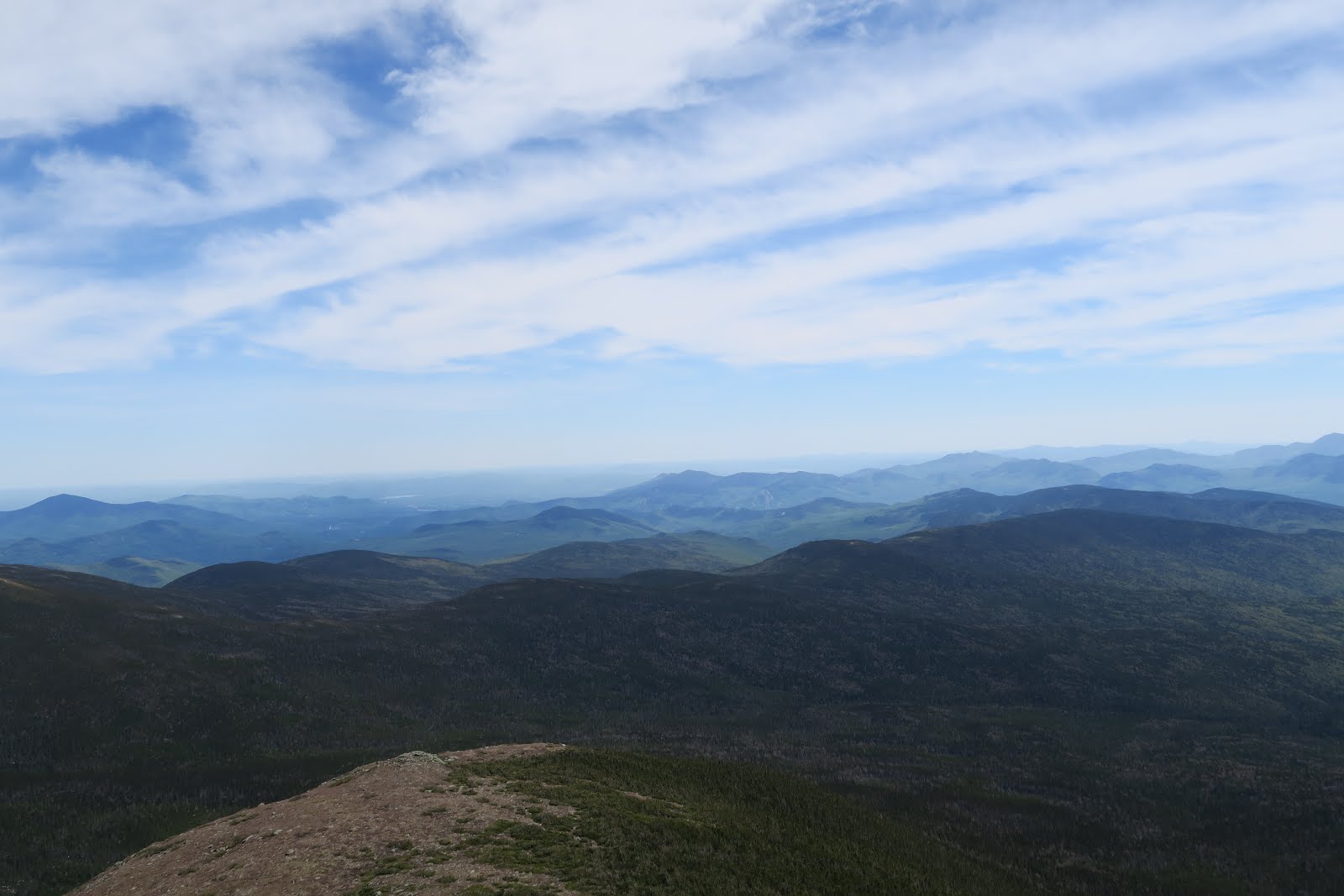
Beautiful view
 
To go go the cave, people need to hike, then take a cable car, then hike to go to the cave. The each hike was short but really beautiful. I fell in love with European Alps. 
The final portion of the trail is like this in the second picture in the left. 
trail to the cave entrance
Cave entrance
To enter the ice cave is allowed only with a designated guide. 10-15 people go to the cave together. German speaking persons are half, English half. The guide explained the cave structure at the viewpoints in German and English. The ice cave was really wonderful. I had never seen such a big ice. It was blueish and whitish, and half transparent. Inside the cave was dark, but at the viewpoints the guide lighted magnesium sheet (if I remember correctly). That was very bright and lit up the ice structure so beautifully. It was worth taking train and bus. I definitely recommend this ice cave!!!
Because it is prohibited to take pictures inside the ice cave, no pictures: meaning you have to go there.
After the cave visit, I came back to Salzburg and went to a house Mozart once lived. There were several pianos he used. I thought, “Seriously? There are only a couple of octaves! How could he play his piano concerts pieces?” They were like toys. I also saw many letters he wrote. His handwriting looked meticulous.
This day was quite packed, so I slept well at night.

数年前にヨーロッパ一人旅をした。その中で印象深かったハイク。

オーストリアのEisriesenwetlt。これは氷の洞窟。アルプスをハイクしそして氷の洞窟を歩くハイク。すごいの一言だった。

その日は6時起床、6時半朝食。ヨーロッパのホステルの朝食はイマイチ。やっぱり日本の朝食が一番だとつくづく思う。何はともあれ7時にホステルを出発。 まずザルツブルグの中央駅まで歩く。そしてそこからワーフェントいう街へ電車でいく。約1時間。ザルツブルグから10分程度でもう山の中を電車が走っている。綺麗。ザルツブルグに住んだら山行き放題だなぁ、と考えながら車窓を眺めた。”世界の車窓から”状態だ。

そしてワーフェンからバスに乗ってEisriesenwetltに行くのだがバスが来ない。バス停の周りには65歳以上を思われる人しかいないし、聞いてもドイツ語しか喋れない。やっぱり昔の教育では英語はヨーロッパではなかったのか?

バスが来ないので駅に戻り英語が喋れる人を探す。どうやらバスがもうすぐ駅に来るらしいことがわかった。駅にいたドイツ人のおじさんがドイツ語でなんとか教えてくれた。というかジェスチャーと時計を指してなんとか理解できた。

そしてようやくバスに乗ることができた。バスを降りトレイルを登り始めると。。。きゃー。景色が素晴らしい。1枚目の写真が全てを語ってくれている。アルプスは本当に美しい。いつまでも見ていたい。そして2枚目の写真が洞窟にいく最後のセクションのトレイル。”普通”の観光客はかなりヘトヘトになりながら歩いていた。

3枚目の写真が洞窟の入り口から外を撮った写真。

そしていよいよ洞窟の中へ。ここを管轄している公園のガイドと一緒に入る。保護地区なのだ。なので写真撮影も禁止。ということで残念ながら氷の洞窟の写真はないのだが、とにかくあんな氷の洞窟初めて見た!幻想的な氷の洞窟、ぜひとも読者にも行っていただきたい。


2019-06-13

Briones Regional Park Day Hiking

<Japanese version is after English>日本語は英語の後にあります。

There are many great day hiking places in the San Francisco Bay Area. Briones Regional Park is one of them located in the East Bay.

I like parks in East Bay when all the hills get green after rain. Once I went hiking in Briones after rain. I really like a number of rolling hills suddenly all get green in East Bay. It is exciting. 

This day after a big rain, the trail got muddy.  Even though my feet got wet, I thought it was good, because California has been in drought for a long time.  

Usually trails in the East Bay parks are really wide. It is good for me who is super sensitive to poison oak. I even get rash from poison oak by just walking nearby without touching them. Once I had systemic rash for more than 3 weeks. I couldn't focus on working without ice packs on rashes all the time. Without putting ice packs on rash, it was extremely itchy and couldn't do anything! 

Anyway, after rainy days, dirt wide trails even get green. This is pretty. It was nice to walk on a fluffy road. Somehow this park is much less crowded compared to other parks nearby, such as Tilden or Cataract falls. I love those parks as well, but sometimes I need to be at more quiet places. Sitting on green grass and looking at green mountains are precious time. It always energizes me.

At the end of hike there was a big bonus. I saw a coyote! A healthy looking coyote was running on the hill. Maybe he was excited as well on a sunny day after rain. He was running downhill. It was lucky to see such a cute coyote. 

If you are interested, you can check out the map here at official park site. There are many trails: you can hike short or long. https://www.ebparks.org/parks/briones/default.htm

いうまでもないが、サンフランシスコ・ベイエリアにはたくさんの綺麗な公園がある。そのうちの一つがブリオネス・リージョナルパークだ。

イーストベイの公園は茶色の丘であることが多いが、雨季の後には一斉に丘が綺麗な緑に覆われる。この時期が一番好きだ。

と言っても過去数年はカリフォルニアはずっと干ばつで雨もほとんど降らない状態だったので緑の期間も少なかった。なので時期を狙ってハイキングに行った。

この日はブリオネスパークに雨の翌日に行った。前日は大雨だったのでトレイルは泥沼状態だったがそれでも雨の後の緑の丘はとても綺麗だった。

イーストベイのトレイルは大抵とても幅広にできているので歩きやすい。泥だらけでもなんとか泥を避けながら歩ける。もう一点、幅広で良い点はポイズンオークに触れずに済むことだ。

ポイズンオークは日本語だと漆。ウルシオールという油が植物には含まれてており触れてしまうと皮膚炎が起きる。ただしウルシオールにセンシティブな人(ウルシオールに対する免疫反応)のみ。

私は・・・ウルトラセンシティブ。例えばウルシオールが含まれた水たまりに足をちょっとだけ入れてしまったとして、その水の一滴が足に跳ねたとしよう。2日後にその部分が強烈な痒みに襲われるとともに、ひどい湿疹ができるのだ。

一番ひどかった時は体全体に発疹が広がり仕事中はアイスパックを腕と足につけておかないと痒くて仕事にならない状態になった。1ヶ月間もだ!その1ヶ月はハイキングもできず。強力なステロイドの軟膏をつけなければならない。無意識に掻いてしまった時は感染し、抗生物質も服用した。ポイズンオークには読者も本当に気をつけてほしい。現在免疫反応がなくてセンシティブでなくてもいつ免疫反応が確立するかわからないのがポイズンオークだ。私は免疫の研究をしているのでこの点は本当だ。

それはともかく。。。

このハイクでのハイライトは緑の綺麗な丘とともにコヨーテを見たことだ(最後の写真)。丘をかけていくコヨーテを見られたのは貴重で非常にラッキーだった。

2019-06-11

2nd Connecticut Lake and Lake Francis

<Japanese version is after English: 日本語は英語の後にあります>

Beginning of June weekend we went car camping and kayaked. 

Usually we prefer to go backpacking rather than kayaking, but this time we decided to car camp and kayak on the lake. The reason is that I had a neck pain (story for neck pain will come soon).

On Saturday we kayaked on the Second Connecticut Lake. Although it is named Connecticut, it is in the state of New Hampshire. Actually it is almost Canada (very close to the border). This lake is in the town of Pittsburg in New Hampshire. It is confusing! The famous Pittsburgh is in Philadelphia, but this is Pittsburg in New Hampshire. Please note the spelling is different. 

Second Connecticut Lake

Going to the lake is via unpaved road. In the parking there are two cars, and they are fishing on the shore next to the parking lot. Those a couple of fishing people are the only humans at the lake. 

On the water, nobody but us.  We kayaked the shore of the lake. It took a couple of hours. The entire kayaking, it was very remote. It is nice to be on the peaceful water.


On the lake we saw loons and geese. Looks like loons were fishing. They are very good at catching fish. Loons sometimes went into the lake for a while. They seem to be able to hold breath for a long time. Then they show up with fish in sometimes 50 meters away. They swim very fast!

The left two picture are the moment the loon went into the water (upper picture) and the came out on the water (the bottom picture). 

Mr.N told me that they can swim but they can't walk on the ground. Interesting. 


After kayaking, we camped at the campground in Lake Francis State Park. A thing you can do at car campground but not backpacking is BBQ. This time we cooked beef and corn over the fire. Delicious!

The next day we kayaked on the Lake Francis. There are many people on the lake and everyone was fishing. It looked like there are many fish. Ummm. Meat over the campfire is good, but I thought it would be nice to have fish just caught cook over the fire. It made me think about getting fishing license. However I thought twice and I have to go fishing a lot to get worth of fishing permit fee. 

OK. Probably it is easier to buy fish at grocery stores. 

Fishing people were staying on the same spot, so only us paddling and moving on the lake. We explored the inlets and outlets. It was always nice to be on the water. Again we saw loons. 

After satisfied with kayaking, we headed back to home.

6月最初の週末はカーキャンピングとカヤック。

バックパッキングの方がカーキャンピングよりも好きなのだが、5月半ばから首がずっと痛かったので今回は大事をとってカーキャンピング。首を痛めたのはバックパッキングが原因なのだが。。。その話はまたそのうちブログに書く予定。

土曜日は第二コネカット湖でカヤック。コネチカット湖という名前だが実際にはニューハンプシャー州にある。ニューハンプシャー州の一番北で、カナダがすぐそこにあるのだ。このコネチカット湖があるのはピッツバーグという街。ピッツバーグといえばフィラデルフィアにある大きな市が有名だが、ニューハンプシャー州にもピッツバーグが。。。しかしスペルが一文字だけ違う。ぎゃー。ややこしいな。

湖に行く道は未舗装道路。駐車場には2台の車が止まっていて何人かが湖岸で釣りをしていたが、湖に出ているカヤックやカヌーはない。

我々が湖を独り占め。湖はとっても静か。

ルーンを何羽か見た。時々水の中に潜って魚を取っていた。潜ると必ず捕まえている。さらにかなり長い時間潜っている。息、かなり長く止められるようだ。しかもかなり離れたところに現れるので泳ぐのも上手なようだ。最初の3枚の写真が第二コネチカット湖の様子+ルーン。ルーンの写真は水に潜ったところと水から出てきたところ。

そして近くのレイクフランシス州立公園のキャンプグラウンドへ。

ディナーは肉!とトウモロコシ。キャンプファイアーで調理。

やっぱりキャンプファイアーで焼いたものはなんでも美味しい。バックパッキングではコーンなど持っていけないので(重すぎ)、たまにはカーキャンピングも良いなぁと思った。

次の日はキャンプグランドのそばにあるレイクフランシスでカヤック。カヌーやモーターボートで釣りをしている人が何組かいたが、普通にカヤックやカヌーしている人はいなかった。釣り人は湖に出ても同じ場所に佇んでいるので動いているのは我々だけだった(笑

川が湖に注ぎ込んでいるところを見たり(2つの異なる川が違う場所から流れてきていてこの湖ができている)、ルーンを見たりして午前中のカヤックを楽しんだ。

そして午後、帰路へと着いたのだった。


2019-06-09

Mount Monroe

<Japanese version is after English: 日本語は英語の後にあります>

It was a great day to be outside in the mountain.

We hiked up to Mount Monroe in the Presidential range in New Hampshire. It was a sunny day and the view was fantastic.

We started at Edmond Path trailhead. We arrived around 10:30 a.m. and already 20 cars were parked. There was still room for 10+ more cars. So it was good. I went into the bush for toilet. Then I got a bug bite. 

Ugh. I forgot to put bug spray before peeing.

I am so sensitive to bug bites. Mosquitoes, noseeum, No-see-ums, etc. When I am in the wilderness, mosquitoes bite only me not Mr.N. So unfair. When I put DEET and Mr.N doesn't, they go to Mr.N. He can use me as a guard. 

The bite might not be by a mosquito, since I got a bump and felt itchy within five minutes before starting the hike. 

Anyway we started walking. The first part about 3 miles is in the forest.  2400 feet elevation gain in the 3 miles, then suddenly the view came, because it passed the tree line. It is amazing how low the tree line is in New England. The climate explains it. 

The "fake peak" Mount Franklin: looked the highest
3 peaks appeared!

At the junction at mile3, one direction goes to Mount Eisenhower, the other goes to Mount Monroe. We had done Eisenhower, so we went left for Mount Monroe. We thought the peak we could see from the junction was Mount Monroe, but when we reached there, there were another 3 peaks appeared. Yes, that was a fake peak. If you are a hiker, you know this feeling. Hiking up and up and up to the visible highest point where you believe the top of your hike. Then ALWAYS higher peak appears when you reach there. 

The "fake"peak was actually a Mount Franklin, so it was an official peak. Sorry, Mr. Franklin. It was really good view at Mount Franklin, but we continued to go to Mount Monroe. There was small hill to hike up before Monroe, then went down a little, then finally hiked up to the Monroe. 


The view was very good! It was lucky to be sunny day on the weekend. The countless mountains were there until the horizon. It was like a ocean wave. The Monroe is just next to the Mount Washington, which is the highest in the Presidential range. People can drive up to Washington, but not for Monroe. So it is much more peaceful and nice. I saw several trail runners near Monroe. They were serious, and probably doing all the Presidential peaks in a day. Despite such hardcoreness, they politely greeted and thanked us when we yielded the path. I thought that the same thing happened when I was hiking Tour du Mont Blanc. The trailrunners were super hardcore there, but super polite as well. They are very very impressive and admirable.

I found a good spot where the winds are blocked and ate lunch. It is always nice to have lunch with great view.


It was also nice to see cute flowers above the tree line. 

There is a hut down the Mount Monroe, so we went there to check it out. We saw a guy taking video at the top and saying he and his wife were going to stay there. We filled the drinking water at the hut and went to the restroom (they are free for any hikers). Grrr. The toilet was very stinky. I should have used "wilderness restroom". They sold self service tea (pot with hot water was there, $2), but I carried hot coffee in the Zojirushi insulated mugs, so I didn't need it. I love my Zojurushi's insulated mug. It is an essential item for hiking, especially in cold New England. 

Then we headed back. Nice day!  

今回はモンロー山へ登った。快晴の日で景色が素晴らしかった。

モンロー山はニューハンプシャー州にあるプレジデンシャル連峰のうちの一つ。

今回は16キロ、1070メートルの登りのルート。まずエドモントパスのトレイルヘッドからスタート。スタートする前に草むらでトイレに行ったのだが、ここで蚊に刺された。

ぎゃー。虫除けスプレーする前にトイレに行ってしまった。

MrNは全く蚊に刺されないのだが私はいつも蚊に刺されまくるのだ。私がDEET入りの虫除けを塗っている時のみ蚊はMrNの方へ行く。まったく。

そして日よけ、虫除けをつけてスタート。スタートする頃にはすでに刺されたところが痒い。。最初の5キロは森の中。ずっと上りが続く。そして5キロのところでジャンクションがあり突然森から抜け出る。いい眺めだ。右へ行くとアイゼンハワー山、左へ行くとモンロー山へと行く。

ジャンクションから見える左側の山がモンロー山だと思い歩いて行く。景色が良いので歩くのも苦ではない。しかし、一番高いと思っていたところに着くと、新たにさらに高い山が登場(1枚目と2枚目の写真)。

山登りをしている人ならわかると思うが、これ、よくある。あ!あそこが頂上だと思って歩いてそこに着くとさらに高いところが現れるやつ。マウントホイットニーでは2−3回そういうのが現れた。

そしてようやくモンロー山へ到着。景色が素晴らしい。山が波のようにどこまでも続いている。空気も美味しく最高だった。風は強かったが岩の陰のスポットで風が一切来ないところを見つけてそこで昼食のサンドイッチとM&Mのチョコレートを頬張った。

頂上付近では高山植物の花がたくさん咲いていて綺麗だった(最後2枚の写真)。

そしてモンロー山の麓にある山小屋へ寄った。山小屋ではハイカーはトイレ使用可、そして飲料水も補充可能だ。トイレはもちろん水洗ではないので臭かったが。。。まあ仕方ない。

そしてトレイルヘッドへと戻ったのだった。良いハイクだった!


2019-06-07

Ed R. Levin County Park Day Hiking

<Japanese version is after English 日本語は英語の後にあります>

Ed R. Levin County is a very pretty park located in Milpitas. Milpitas is a town in the San Francisco Bay Area. Milpitas is located at the end of the Bay, at the border between East Bay and South Bay. 

Nice View

When you climb at the top of the hill in Ed Levin Park, you can see the end of SF bay. It is interesting and nice. Hills are green in the spring. It is pretty. 

I went hiking this park with Mr.N, Ms.M, and Mr.B. Three of them are Americans. One thing I like to do during the hike in addition to enjoy the nature is learning English idioms. Especially Mr.B, as know as a book worm, has a tremendous knowledge of idioms and trivia. During this hike, I learned peanut and animal related idioms. For peanut ones: "peanut gallery", "peanut to an elephant", "if you pay peanut, you get monkeys". For cats: "a cat has nine lives", "cat nap", "cat soup". For mice: "quiet as a mouse. For rats: like rats abandoning a sinking ship.

Ms.M is my former lab member and spent 5 years on the same project together. She taught me how to survive in the U.S. It is always nice to hike with favorite people. Mr.B is Ms.M's significant other and he has unbelievably large vocabulary its etymology, and trivia. It is always fun learning something from him, especially during hikes!

エドレビン公園。写真が全てを説明してくれているが、すごく綺麗な公園だ。

エドレビン公園はカリフォルニア州サウスベイとイーストベイの境のミルピタス市にある。サウスベイとイーストベイの境:つまりサンフランシスコベイの終わりの部分にある。つまりベイの端が山の頂上から見える。

とある休日に、MrN、MrB、MsMとここへハイキングへ出かけた。MrMは元同僚で、MrBはMsMのパートナーだ。ハイクした3人は全員アメリカ人。MrBは本の虫そしてトリビア王だ。こういう時に私が好きなのはアメリカのイディオムを習うことだ。私は以前からMsMに英語を教わっていて、イディオムをよく習っていた。MrBはMsM 以上のイディオムを知っており、その隠された意味まで知っている。なのでイディオムや新しい語句をMrBから習うのは楽しい。

。。。少しハイキングから話が逸れているが。。私がハイキングしながらする好きなことの一つとして”馬鹿話”をすることなのだ。親しき人たちと良い景色と空気の中で馬鹿話ができるというのは幸せなことだと思う。そしてそんな馬鹿話が笑顔を作ってくれる。

今回学んだのは、ピーナッツが含まれるものと動物が含まれるイディオム。

ピーナツギャラリー、象にピーナッツ、もしピーナッツを払うのなら猿を得る、猫は9つの命を持つ、猫の昼寝、猫のスープ、ネズミのように静か、ラットが沈みゆく船から捨てられる。

アメリカ人でも知らない人が多いこれらのイディオム。さて、読者は何個知っているかな?


2019-06-05

Parc National du Mont-Tremblant, Quebec, Canada-Day3

<Japanese version is after English>日本語は英語の後にあります。

The final day in the Parc National du Mont-Tremblant. 

We woke up at 6-6:30 a.m. and had a campfire. Over the fire we cooked sausages. Original plan was to cook over fire at the first night and the second night, but the first evening was raining, so sausages were still remained. We brought all the way, so why not cooking for breakfast? Sausages were delicious! 

After breakfast, it started drizzling. We were debating if we should go short hiking or kayaking. It is not very fun doing activities under rain. 

First we decided to drive around the park. The park is actually really big. Shortly after, rain stopped. So we decided to kayak on the Lac Escalier. It is another lake in the park. 

Probably because Memorial Day in the U.S. is not holiday in Canada,  there is not a single human in the area, except for park rangers. It was very quite in the entire park. That was really nice.

Lac Escalier

The amazing thing about kayaking on this lake was being so secluded. The big whole lake was entirely ours. Not a single kayak was there for the whole time we were kayaking. This lake doesn't have much buildings around: except for (probably) one hut. Water was calm, so it was easy to paddle. It was nice to paddle on a peaceful lake.

During this trip in the vast Quebec nature, I really enjoyed the real wilderness. 

After kayaking, we headed back for the U.S.  Again we stopped at Montreal. This time we got smoked meat sandwich and poutine. According to Google, smoked meat is Montreal thing. The smoked meat was really tasty! I ate sooooo much meat. Poutine is french fries with gravy. I am not particularly a fan of poutine, but it was experience. 

For the border control, we accidentally went to the lane of NEXUS, which is probably pre-registration is required. Nicely nobody was in the lane, the officer let us pass the NEXUS lane. Then we came back to Boston around 9 p.m. 

Now I explored Eastern Canada twice: it is nice to go back again.

カナダ、ケベック州、モントランブラン国立公園キャンプの旅最終日の3日目。

6時半頃起きて朝のキャンプファイアー。火でソーセージを焼いた。本当は1日目と2日目の夜に焚き火で夜ご飯を作る予定だったが、1日目の夜は雨だったので3日目の朝にソーセージをバーベキューすることにしたのだ。

読者は朝からソーセージ!?と思うかもしれないが。。。美味しかった!

そしてエスカリアー湖でカヤック。カナダではメモリアルデーは休日ではない模様で人っ子ひとりいない。パークレンジャーしか見なかった。ものすごい大きなエスカリアー湖で我々だけがカヤックしている。ものすごく静か。うわー。最高の贅沢。こんな綺麗な湖を静かに独り占め。

モントランブラン国立公園では広大な自然を満喫することができて満足。

そして帰りに再びモントリオールに寄り、モントリオール名物(グーグルに夜と)らしいスモークミートのサンドイッチをゲット。これ、美味しい。そしてスモークミートが5センチくらいパンに挟まっている!

そして東部カナダ名物のプーティンも食べた。プーティンはフライドポテトにグレービーがかかっているもの。まあ、2度目はない味。

モントランブラン国立公園、綺麗でとても良いところ。また行って違う湖でもカヤックしてみたい。