Showing posts with label Backpacking in New England. Show all posts

2020-09-10

Carter Dome Backpacking in New Hampshire

Another 4000 footer in New Hampshire!

Overnight backpacking
Type: loop with a spur
Distance: 11.53 miles (18.6 km)
Elevation Gain: 3,281 feet (1000 meters)

Summit in the loop: Carter Dome (4826 feet high, 1471 meter high)

near trailhead

This time we went backpacking focusing on Carter Dome (4826 feet). Trailhead is on the dirt road near Prospect Farm, near highway16. First we started ascending wildcat river trail. The first portion is in the nice forest. At mile 3.5, there is an unofficial tent site. It is a very big site with a fire ring. Good to know for the future trip. 

Soon after that, we reached the Carter Notch Hut. Of course this summer the hut is closed due to pandemic. However, a caretaker was still there (actually she was on the roof reading a book, nice) and still some snacks were sold. Some bars were at the window and if you want to buy it you can put cash into a bin. 

Owl on the guard


If it was open it looked really cozy hut. There is a main hut building and there is another building for beds. As you can see in the right picture, each small room has 4 bunk beds. It is nice not the giant room with 20 beds, but multiple small rooms with only 4 beds. If your party is 4, it is like a private room. Currently the rooms were locked. Cutely, an owl was guarding!

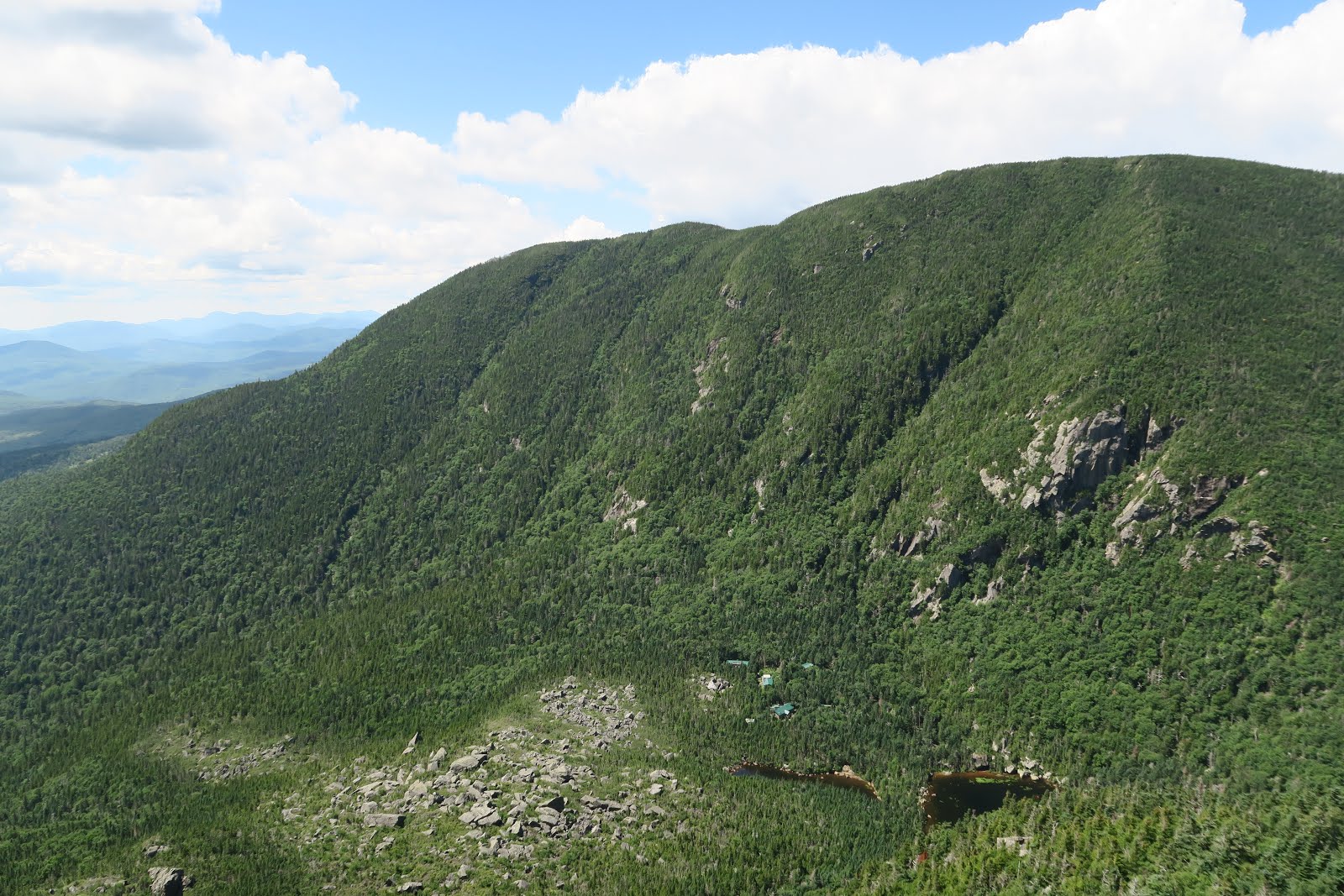
Carter Dome over the pond

From the hut the Carter Dome looked pretty. The summit is over the pond. As you can imagine, 1600 feet elevation gain in 1 mile.....Steep! Especially with a overnight backpack. Between hut and the top, there is small spur trail to the view. This is a must to check out, because there is not a nice view on the summit, in fact.

pond and the hut down there

The picture in the right is just 0.2 mile from the hut. You can see the huts and pond way down there. Only 0.2 mile of climb. You can tell how steep the trail is. However, it is indeed a nice view: rewarding climb. Here we saw a hiker with a doggy. It was a black pomeranian. Wow. I always thought pomeranian is a spoiled dog always inside where A/C is on in summer. I learned that they can do strenuous hikes on a hot day. 

raspberries

After Carter dome, we descended via Rainbow trail. This trail is not popular, so not well maintained. However we got bonus. A lot of raspberries. Tasty! We ate a lot of them like bears. After rainbow trail we took wild river trail to backcountry campsites, Perkins Notch Tentsite. Tentsite, but just some flat areas with nothing. We had relaxed evening time at the site with campfire.  

The next day we hiked out by only 4 mile walk.
It was a nice weekend. 

2020-07-26

Backpacking in Nash Stream Forest

On sunny weekend in July we went backpacking in Nash Stream Forest Area. This time a little hardcore schedule.


<Overnight Backpacking>
Trailhead: Crawford Notch Road (302) and Notchland Road
Total mileage: 21.82 miles
Elevation gain/loss: 5,869 feet

Route: Trailhead-Davis path - Mount Davis -Mount Isolation -Rocky Branch Trail- Stairs col Trail- Davis path-Trailhead

Type: lollipop (first potion is out and back, then loop)

Mount Davis

Due to relative long distance per day, Mr.N suggested leaving Boston at 4 a.m. Four. That means that we needed to get up at 3:30 a.m.! We arrived at the trailhead around 7 a.m.  Surprisingly there are more than five cars already there in the parking lot. The first 4 miles was repeat we did before with a hiking club. It was funny I didn't remember at all about the steep uphill portion for the first 3 miles, but I remembered very well after the point it got to the ridge and much less steep. I have heard that human brains eliminate unpleasant memories, and I thought that this was a good example. At mile 8, we went up to the first mountain summit, Mount Davis. This is a 0.2 mile steep spur trail from Davis path. It was worth taking an additional mileage. 

Mount Isolation

Then next was Mount Isolation. This backpacking can have multiple mountain summits, which is a bonus for long distance backpackers. Mount Isolation is a 0.1 mile spur trail. Again this was worth the stop. I wonder the name of the mountain was because it is isolated. Even now this summit is 6 miles from the closest trail, which is relatively long side compared to other mountains in New England.  

Sign!
camping spot

Then we headed for the campsite. It is a primitive campsites on the first come first serve basis. We hoped that there would be space and also would hope water source. We were not sure where exactly the campsites were, but we found a small sign on the trail (right picture). There were some flat spaces and luckily there were no one at 4:30 p.m.  We took the largest flat spots and started campfire! My favorite activity. There was already a big fire ring. The trail was muddy and the all logs on the ground was wet. Due to the wetness, it was hard to start the fire. 

Later after 6 p.m., group of 5-6 came asked us if there was more further our spot. We said no.  Looked like they were jealous about our spot. They had to take smaller, uneven spot. Early bird gets the worm! Those people pitched the tent over the some bush/trees of our site. I heard they had marijuana and got chatty. Luckily they went to bed as early as us and got quiet.  They seemed to fail to start the fire, that might be the reason they went to bed early. Also Mr.N heard that they were talking, "The hike was so hard. I don't know if I can go back tomorrow." That might be another reason they got quiet early. Good!

Pretty fall

Next day the first 2 miles was soooooo muddy! Grrr. I assume all the mud came from a lot of rain during the week. It was tough to hop on rocks no to get stuck in the mud, however, the bright side was falls were pretty (left picture). There are not many falls of this type (wet, mossy, hidden) in the West. This type of falls are usually in the forest and it always reminds me of Zen, from a viewpoint of Japanese. The beauty presents deep inside of these scenery. 

Cairn

After 2 miles, we hiked on a most isolated trail, rocky branch trail. Most people go to mountain summits in a shortest way. The Rocky branch trail, which is full of rocks and branches actually, is not the trail for any mountain in a shortest route. We indeed didn't pass anybody in the entire rocky branch trail. I really liked the rocky branch trail, not only isolated, but also trail was rather well marked. There are many river crossing, and it was marked as a cairn (the picture in the upper right). Sometimes two cairn was found in the opposite direction, that is often happened on the abandoned trail. The trail finding was fun. 

5,869 feet elevation gain and loss was hardcore, but it was a good one. 

2020-06-27

Backpacking in Sandwich Range

Getting away from hot humid Boston for weekend is good. One weekend in June, we went backpacking in the Sandwich range in New Hampshire. 

First picture was Lady's slipper. I learned the flower's name after I got home. It looks like a lady's slipper....may... be. We saw pink ones and white ones. White one is interesting, because their vessels were seen in pink. It looked like blood streams. Both look pretty and vulnerable. Seeing something time-sensitive stuff is grateful. 

Somehow it was hard to focus on Lady's slipper. It took some time to get nice focus on the flowers. We behaved like Mr.B3. He is a photographer, and loves taking wild flowers, especially in Montana. Mr.N said that he might text these pictures to make Mr.B3 jealous. 

viewpoint
sunset is approaching
sunset

After a couple of hours, we reached the planned camping area. Hiking book indicated that there might be some some camping spots near Mount Paugus. The west side of summit there was a party already set up a camp, although we didn't see it because the site was in the trees. We noticed that some human voices and smell of campfire. We searched a potential flat space that is big enough for one tent. We found it in the east side of summit. It was just 10 seconds for a great open view point, but our site is protected by trees. It was perfect! Now in June, daytime is long is sunset is late. That means that there is enough time to see sunset, even though sunset is earlier in the mountains. We went to the viewpoint and waited for the sunset. The right picture is again from the same viewpoint, but due to the light direction, it looked like a totally different place. It was beautiful scenery in the warm orange sunlight. 

viewpoint in the morning

Then we observed sun setting. It was nice to see sun go down to the ridge line. Somehow clouds formed one straight line and sun set could be seen between the cloud line and ridge line. After the sunset we enjoyed campfire, dinner, cookies, tea, then slept. In the morning, again we enjoyed campfire. After breakfast, we took down the tent. I took several pictures at viewpoint for the final look before going down. It was nice to stay near the viewpoint, because i enjoyed many different beauty at the same place. 

2020-05-30

Backpacking in Wild River Wilderness


During memorial day weekend, we went 2 nights/3 days backpacking. I want to make sure to practice social distancing during this covid-19 outbreak, however, recently it is getting difficult to do so on trails. First of all, snow has almost melted in New Hampshire, meaning more hikers come hiking. Secondly, not many people are careful about social distancing.
To overcome this issue, we chose unpopular area to hike. What is unpopular? First, it is the area without 4000-footers. 4000-footers are the mountains higher than 4000 foot high. In New England, there is the list of 4000-footers, and the list persons do those >4000 feet peaks. Actually there are so many list people. It is surprising how little hikers are for the 3998 foot high peak. 4000 foot mountains without views are much more popular than 3999 foot mountains with great views in New England. We don't care the list (I know that Mr.N secretly records which mountains we hiked, though). Based on this observation we went backpacking in the Wild River Wilderness.
First day is the easiest. Only 3.3 miles. The trail is along with river all the way and several time needed to cross. There is no bridge. This is another reason the area was not popular. In fact, it seemed like this is much bigger facto to make this area isolated.
Since we were not hiking for the past 3-4 weeks due to outbreak and mostly we went kayaking, it was really nice feeling to be on a trail. The temperature was above 20C (probably above 70F) with full of sun. I felt like the summer suddenly came! Our last hike was snowshoeing actually. What a difference.
After snow is gone, there are pretty flowers. 

We saw at least two colors of trillium. White and red. 

The white one has nice pink/red color in the center. It is very nice to see flowers. 

Then I had a big moment in the 1st day morning. 

I saw a mother moose and a baby moose!!!!!

We were hiking quietly, I was on the first and Mr.N a little behind. I heard some noise in the forest and I stopped and looked around. Oh wow. There is animal! I stared at her and she stared at me for a few second. Then Mr.N came and said, "Moose!" Then we noticed a baby moose!!!

The mother moose was black, and the baby was brown. The baby was in a little lower place from mother. Mother must have signaled baby to come and baby had to climb the tiny hill. The baby struggled a little to climb it. Aww, cute! Then they disappeared deeper into the forest. 

I would say that this was my first time seeing moose. More precisely I had seen moose in Grand Teton, however, it was too far and I just spotted it as a black dot. I was on the top of mountain and looking down the bottom of valley. The valley was at least 1000 meters below, so moose was just like a dot. I wouldn't feel like I saw a moose. Thus this time was the first time! So happy I saw moose and a baby moose!

Meadow

The trail continued pleasantly: flat and sunny. 
Beaver's trace

Another finding a little later the encounter of moose was a lot of trees cut by beavers. There was a small creek. It looked like a river beavers really like. We saw trees fell by being eaten by beavers, and trees beavers half way and almost done to be cut. By making trees fell, beavers can eat upper portion. 

The left picture is the trace of beaver. The tree was cut by beaver and the tree has beaver's teeth  marks. Cute!

Many animals live in the forest. Fun!


River crossing

Last portion of the first day before reaching a campsite was river crossing. The river appears to be shallow, but it actually knee high (right picture). Also the water is just from melted snow, so it is very cold. 

our tent
Campfire

After crossing we reached the backcountry campsites. This is free, designated camp area in the backcountry.  Good thing is fire is allowed! Indeed there was already a fire ring. Moreover, logs are everywhere in the area. Immediately I arrived at the site, I started foraging. Dinner and campfire is the best combination for the night. Bonus was evening birds' calls. Those voices are nostalgic and beautiful. 

I had a nice sleep with river sounds whole night. Usually first night of backpacking I have a less deep sleep, but this time was perfect.
Next morning was beautiful. It was nice to wake up in the forest. Now morning birds' songs came. Now those are cheering and cute. Morning started with breakfast and, of course, campfire. 

River crossing
Eagle Crag

The second day had several river crossing again. One of them was especially scary, because just downstream we crossed was a little falls and upstream was also falls (left picture). It means deep and and power of stream is high. Due to large frequency of river crossings, many people don't choose this tracks. This means this area is really empty. Indeed, until we came to the point that can be accessed without river crossing we didn't see anyone at all. Solitude was nice. Mr.N said no bridge is like Montana wilderness. I love deep wilderness without humans. For safety-wise we have Derome Inreach (satellite device). 

Then we ascended to Eagle Crag which was the highest point of the backpacking and had lunch. Lunch was crackers and tuna. Delicious!

Morning forest

The second day night we had planned to camp at another designated backcountry camping area, but there were more than 4 tents already there when we arrived around 5 p.m. So we continued hiking another mile and found some good spot in the forest.  Dispersed camping is solitude and nice. Next morning we walked a few miles in the nice quiet forest and wrapped up the backpacking.  


2019-10-28

Mt.Willey and Mt.Field Loop Backpacking

In mid-October in a cold day we went backpacking. This time we did a loop covering Mt.Willey and Mt.Field in New Hampshire. Total was about 15 miles with 4500 feet elevation change. 

Starting point was at the train station of Crawford. The hike starts by crossing the train track. As I went up high, the air got cold. Actually it was so cold. 

Two weeks ago when we went backpacking, we saw very pretty fall colors: yellow, orange, and red. Now all leaves are gone. There are still colorful leaves on the ground, but the view is brown. It was amazing how quickly seasons change in New England, especially summer to autumn, then winter. Now, long winter has began. 

Only a few miles from trailhead, the view was already winter wonderland. Trees were snow covered and trail were also covered with white. Wow. We didn't know it was already winter there and didn't bring microspikes. Winter seemed to come in such a hurry, and still red berries were on the ground with snow as if they were saying it was too quick transition.

Also my shoes got wet. Due to heavy rains on weekdays before our hike, the trail was extremely wet and muddy. Then trail went up about 1500 feet and we reached a junction to the Mt.Tom. To go to Mt.Tom it was 0.6 mile of 300 feet elevation gain. Because it was a spur trail, I didn't feel like going. Besides, a hiker who just came back from Mt.Tom said, "There is no view and the trail is muddy."

While Mr.N and I were thinking if we went or not,  the hiker said, "But you can go to 4000-footers."

Grrr.... to be honest I am a little annoyed by 4000-footer list. 

4000-footer is a list of mountains those are higher than 4000 feet in New Hampshire, or New England. There are separate lists for each. A lot of people do the list. So if the mountain is 4001 feet high, I see many hikers on the trail, even if there is no view at the top. If the mountain is 3999 feet high, there is barely no hikers even if the view is really great. I am not a list person, and I would rather enjoy nice view for hiking. I prefer to do 3999 feet with nice view. 

There is an official 4000-footer club managed by Appalachian Mountain Club, but you need to pay to join. Upon completion, you can buy patches. Still paying for completion?! I personally don't like it. Hiking should be always free! OK. It is okay to pay a little. For 2-week John Muir trail for $5 as I did. 

Well anyway, the U.S. is a free country. AMC can do whatever they want, but I can say my opinion freely as well! 

So we just skipped Mt.Tom and continued the hike for the next viewpoint. After passing Mt.Tom, there was hardly nobody, which was nice. This was the 4000-footer list effect. After a few miles later, we met two backpackers on the trail heading towards Mt.Tom. They said, "You guys are the first hikes we met today" You see how big the 4000-footer effect is. 

Soon after that we started to look for a place for lunch. We found a nice disperse campsite near the stream. The ground was dry and nice. I found a fire place. As a campfire junkie, I couldn't help starting fire during lunch break. There are many birch trees nearby, so I was able to find paper birch everywhere to start fire. Campfire at lunch break. SOOOOO much fun. 

Nice Pond

After lunch break, clouds were cleared up and blue sky came. The air got a little warmer. It was really nice. The trail was also nice along some ponds and ridge. 

We passed near the Zealand hut. We didn't pass exactly the hut, but turned the junction nearby. The junction has a hanging sign saying "hot food for sale at hut". Ha. Hot food sounded nice, but I knew that the hut foods were very American, so I didn't check it out. Also it was a detour. As a Japanese, I always like hot Japanese food in the outdoor setting: ramen, udon, soba, Japanese curry, Japanese pasta, etc....I am picky. 

On the ridge there was talus. It is quite unusual to see talus in New England. My memory of talus is always linked to pika. Pikas live in the talus. I always see whenever hike in the high county in the Sierra or Rockies I see many cute pikas. Sadly there are no pikas in New England, probably because it is not high elevation enough for them. I miss pikas. 

Soon near the talus region, we saw a hiker with big beard. He was a though Appalachian hiker! He did southern states, then did Maine, then came back to New Hampshire and going south. Mr.N said that this kind of thru hike is flip flop hike. The hiker was cool. He said, "I see a light in the tunnel" Good luck to the hiker.

 After 4 p.m, we started searching a campsite. The official campsite was along the Ethan pond. There are several developed site (still dispersed) at the Ethan pond. Usually those official site, 0.25 mile before and after the site was prohibited to camp. We were hoping that fire was allowed there, but we saw a sign it was prohibited. White Mountain National Forest allows fire below tree line, because it is National Forest. However, Appalachian Mountain Club that is maintaining the forest on behalf of National Forest makes their own strict rules and some portions, such as official campsites, are not allowed to have fire. 

Because campfire is always my highlight of backpacking, we decided to continue walking. However, it was only 0.6 miles to be flat. After that really steep climb starts, so it was unlikely to have flat camping spot. 

We searched a possible camping spot, however, all the ground near the trail was extremely wet. Actually trail has continuously small log bridge due to the wet. Along the trail was very mossy, meaning probably tent would be sunk if it was pitched. 

We searched 0.55 mile of 0.6 mile. I was optimistic: I thought that there would be something we can do always. I thought that we could avoid a steep hill and continue a different trail or worst case we could go back to Ethan pond. In contrast to me, Mr.N was upset. 

campsite

At the 0.59 mile, I found an established dispersed site!!! An establish site means a flat spot without trees and obviously it has been used for camping for many times by many hikers. Even nicer fact about the site we found was that the big fire place was there! (see the picture left)

We had a biiiiig fire at night and had a biiiiiig fun. 

Campfire

Next morning, we of course had another morning fire.

While we were having breakfast by the fire, a group of backpacker guys passed by. The site was a little off to the trail, a lot of people could miss it. 


The guys' conversation we heard:

A: It is stinky here. Did you fart?

B: No, it is from campfire there.

A: Oh campfire there. 

B: And I farted.

A: OK.

It was funny. Mr.N said that farting was not a big issue between guys. 

Ha! In-tere-sting.

Ladder

2nd day's climb was tough. 2000 feet in 0.8 mile. Grrr. It is like Mount Shasta. 

Some portion has 8 sets of ladder. 

As we climbed, the scenery got fall from winter. Above 3500 feet is covered with snow and ice. 

Winter


We didn't know that trails are already such icy and snowy, so we didn't bring microspikes. We will do need them for sure at next hike. 

From viewpoint Mount Washington was visible. It was snow covered. It was pretty. 

Snow Covered Mountain

Then we finished the hike. All is good.

2019-10-07

Killkenny Loop Backpacking in New Hampshire

October is the best season for fall color backpacking in New Hampshire. First weekend of October, it was luckily sunny both Saturday and Sunday. So we went backpacking in Northern part of White Mountain National Forest in New Hampshire. Because fall colors start in north then go south, the northern part of Whites is good to check out in early October. 

According to the book of New England backpacking, the area we went this weekend, Killkenny loop, is the first portion in the Whites to get fall colors. 

First we parked at the Berlin fish hatchery. Then we walked to the another parking lot where we would finish the loop. There were two options: road walk at the beginning or the end. This time we did at the beginning, because it is kind of tiring to do at the end. We had done several times finishing backpacking by road walking. It was tiring to walk on asphalt after long walk. This one was not bad, because it was unpaved road in the forest. 

Besides, there was a pond along the road and already we saw fall colors, which was a plus. Especially fall colors along the shore was very pretty. After 2 miles of road walking, we started hiking on a trail. The forest is in yellow. It was really pleasant to be in the cheerful color.

Soon four backpackers passed as. They had a cute excited dog. 

They asked where we were going to stay. We said Unknown pond (this is the real name. Not meaning I don't know the name!) or Rogers Ledge campground. They were going to stay at the cabin near the Mount Cabot. The cabin is free and there are some bunks. Nothing is fancy, but small pad is attached on the bunks. There is no need to bring a tent if you stay there, and of course it is protected by rain or snow. They asked where we would stay, probably because they were concerned if they could get bunks, since there is no reservation system but first-come first-served. It was only 4 miles from the trailhead, but they started early enough to get there by 2 p.m. The cabin looked nice and it would be good to stay there in the winter for snowshoeing hike trips. 

View from the Horn

After we chatted with them we continued to the viewpoint just before the summit of Mount Cabot. The view from there was really nice. At the viewpoint, we saw a nice guy who lived down the Mount Cabot. Wow. It should be nice to live near mountains. He said going down after view point without going to the top. Soon we knew the reason. The summit is in the forest with zero view. The guy recommend going to the Horn. A 0.3 mile side trip on the way to Unknown pond. The Horn was.....nice, but the view was blocked by trees. There were two side trips and this one is "recommended" in the hiking book, the other is "highly recommended". So I hoped to see a better view the other one. 

We passed a group who was going to camp at Unknown campsite. They seemed surprised when we said we were going to the next campsite which was 2 mile more walk. 

Campsite
Campfire

We deserved! The next campsite was exclusively ours! There are four official tent site in the Rogers Ledge campsite, but nobody was there. There is a square portion to pitch a tent (see the picture). The campsite is surrounded by yellow and red trees. It was completely silent. It was lucky to be only us. 


There is only one fire ring to share, but all for us. I was so excited about having fire. Tons of trees were on the ground, so it was easy to forage for the fire. To start the fire, paper birch is excellent, because it burns super good. Birch trees were everywhere in the region, so fire was easily started. 

Mountains in NH in October is really cold. This Saturday night, it was below freezing point. At that cold night the warm fire was quite nice. 

The next morning, we did another short side trip to Rogers ledge. The view was marvelous. Red, yellow, orange were all down there! It looked like really someone painted one by one with paint brushes. We are lucky to go hiking in the right time to see fall colors.

Rogers Ledge
fish

After we hiked out we came back to the fish hatchery where we parked. We checked out fish there. They expand trout. Wow. Each section had small, medium, and large trout. It was impressive. However, I don't and will never understand why the plural form of trout is trout!! 


The weekend was nice.


2019-10-01

Bigelow Range Loop Backpacking, Maine

In the late September, we went backpacking in Bigelow range in Maine. 

The previous backpacking on the labor day weekend was extremely hard (2.5 days with +/- 12,000 feet), so this time we decided to do an easy one. The distance was 12 miles, and the elevation change was only 3,500 feet. Another factor we chose this one in Maine was that the internet said that fall colors was happening in the region. 

Hiking in New England. One of  the most famous things in the area is fall colors. New England has clear four seasons. Then, there are many trees in the mountain. So, New England is the great place to see fall colors. 

This fall is my second autumn since I moved to Boston. With taking advantage that I can go hiking in New England every weekend, I plan to see fall colors from beginning to the end. This backpacking is the start of fall colors. 

Saturday early morning we headed for the trailhead of Bigelow. It was 4 hours from Boston. Maine is not very close to Boston, but I like Maine. Compared to New Hampshire where mountains with trees are dominant, Maine has more variety: mountains, meadows, lakes, coast line, peninsula on the Atlantic ocean. 

In fact, the hike started in the lake along the meadow, then went into the forest. 

Lake

Near the lake, there were several campsites. I am not sure these are called backpacking campsites or just campsites, because it was only 0.5 mile from the parking lot. It is free and fire rings were already there. A lot of logs are all over the place. That means an endless campfire can be had! My favorite thing during backpacking is fire in the mountains with logs by foraging (read: free).

Forest

After passing the lake, the trail went into the forest. The left picture is the first portion of forest. It's nice green. Humm? The internet fall color site said it is fall color peak in this area. OK. Green. Well, it is still nice to be in the pretty place. 

Then uphill started. Some portions were really steep. There were a lot of steps made by rocks. The hikers on downhill said to us, "This is the fun part." Me in mind, "On downhill."

After a while, we reached the junction. From the junction we hiked on Appalachian trail. We saw a couple of AT hikers hiking with sandals. After seeing more than 10 AT hikers wearing sandals, I am considering to try hiking with sandals. I am curious. 

Actually I got blisters during the trips in the Grand Teton. Because my feet's shapes are quite unique, it is difficult for me to find shoes that fit well. This problem leads to blisters. Maybe sandals prevent me from getting blisters. 

From West Peak

0.3 mile after joining AT, we saw a nice view, AND some fall colors. It is pretty.

There was a dog on the peak. He tried to catch a bee. The owner laughed and said, "Aw, stop catching a bee!" The dog still tried to catch it. He was adorable! 

After only a couple of miles, we reached our destination, a pond. The pond has no name. There are designated backpacker's campsite. It is interesting system. There are many flat dirt spots for tent campers. Probably I saw 12-15 sites. Then, there are 2 lean-to. For those who don't know lean-to, it is a flat space made by woods with roof. One side is completely open (no wall). If it rains, it is great to avoid getting wet, but with winds, you will get wet. The two lean-to are very large, probably 10 people can sleep in one lean-to. However, everyone was on the dirt site with their own tent, and nobody was in the lean-to. Surprisingly there was only 2 tent site open and others were all occupied. We arrived there around 5 p.m., not too late. It seems that people like to do relaxed backpacking there. We usually arrive at campsite after 6, so it was nice to have long chilling evening at the campsite even though fire was prohibited. 

There was a chatty AT hiker in the campground. She and her partner had been hiking AT for 6 months. She is from GA, and she said, "Hiking in New England is amazing, love it." It sounded like hiking in GA is not great. Also I wondered if she had ever hiked in the West. Mr.N told me that a lot of people on the East coast have never been to West. Whoa. I am sometimes surprised by the fact Americans don't travel much. I heard that many people don't have passports, and even don't go to other side of their own country. Although I know many people travel a lot here in the U.S., it seems people's activity patterns are really divided. 

Pretty red

Sunday was a short hike with only downhill. We saw more fall colors here and there. The left picture is some red leaves. It was nice with sun. 

I am looking forward to seeing upcoming fall colors in this season.


2019-09-20

Grafton Loop Backpacking in Maine Day2 p.m no.2 and Day3

Mr.N walked down on the dry creek to see if there was some water. No luck. 

Then he walked up on the creek. After 5 minutes or so, he shouted, "I found a puddle!"

He actually found small spring. Phew. We didn't need to walk another 2 miles in dark. We settled in and ate pasta for dinner. While we enjoyed after meal tea with chocolate, I saw a small headlamp light coming to us. Wow. A hiker came in very late. 

He talked to us, "My friend is having a rough time with knee issues. He is taking time." 

Mr.N answered, "Oh dear." 

The guy asked, "You guys are the only one here?" 

Mr.N said, "Yes."

The guy said great and went to the site further. 20 minutes or so, the guy having knee issues came in and they pitched tents. We were able to see their tents in the distance. Hmm...?

We noticed that the tents were the same as ones we saw previous night at our campsite. At first when the guy talked to us, I didn't notice the same guy we saw a day before, but I think they were the same guys. Considering the distance and unpopularity of the trail, it is very unlikely for other two guys to have the same tents. 

I always feel nice to have fellow hikers on the same itinerary. We did similar experience having similar itinerary on the Teton Crest Trail in Grand Teton. 

I woke up in the middle of the night I heard sounds of rain hitting out tent. Grrrr. The forecast was "chance of shower", but it was raining continuously. Again I woke up in the morning, it was still raining, but it was not bad in the forest. Trees are so dense in Grafton Loop, actual water didn't come hit too much. 

I went out of the tent and actually surprised. Wet forest was very pretty. It was extra quiet. The rain covered all the noise. 

Wet leaves were shining. The forest was in the moist, which was pretty.

I did enjoy walking in the beautiful wet forest. Well, for a while. At the same time I have to admit it was not very comfortable wearing rain jacket and sweat couldn't go out and the rain jacket was stick to my arm. 

Luckily it was a good distance to be in the forest, meaning enjoyable distance, because the day3 was only about 6 miles. 

Surprisingly, near the trailhead, some people were starting backpacking in the rain. How hardcore they were. 

Super hardcore, and nice loop in the long weekend.

2019-09-18

Grafton Loop Backpacking in Maine Day2 p.m

Between East and West Baldpate

After enjoying the view at the top of East Baldpate, we descended a little and ascended to the West Baldpate. There was no view at West Baldpate, but the way there was nice as you can see in the left picture. 

After here was descending 1800 feet. We descended to the road. There is another trailhead. On the parking lot, a group was doing BBQ for Appalachian trail through hikers. There was a sign of "trail magic"

We saw two AT hikers on the trail after we passed the parking lot. We were on the uphill, but the first AT hiker passed us (we yielded), but the second one yielded us and said, "You guys have the right of way. (for the first hiker) Heard about trail magic and running lol". It was funny. I can imagine how BBQ sounds for AT hikers. 

It reminded me of a day before final day of my John Muir Trail trip. I only had one pack of ramen left for dinner. It was only 2 p.m. No snack for the day or next day. I had to hike out the next day, because of ride. Then I met another JMT hikers who were hiking out that day. They had a bunch of bars no longer needed: they offered surrounded JMT hikers to take them as much as people want. I got 5 or 6 bars. I was really hungry, so it saved me!

Old Speck Mountain

After we crossed the road, we climbed (again.) to Old Speck mountain. 2000 feet of ascend. On the summit, there was not much view, but you can climb the fire tower. The scenic view is offered from the top of tower. In New England it is typical to have a fire tower on the top, since summit is still in the forest. Usually stairs to the top are provided, but this time it was a long ladder! Grrrrrr. It was very scary for me! The view was nice from the top. It was worth climbing the ladder. 

After we climbed, took pictures, went down, and we rested for a while on the ground. 

One day hikers' party came and one guy was saying on the ladder, "Wow this is ***king high!" and joking, "Mommy.....!" 

I was glad that I was not the only one who got scared of ladder.

Another funny incident here was about a dog. A couple brought cute black labrador to the top. The couple went to the fire tower. The doggie couldn't climb the ladder, she had to wait for the bottom. Then she started crying, "Cayn cayn can....!!!" She was feeling unsecured by being left alone. So one of the owners had to come down very quickly. Cute and funny! After 2000 feet climb, the dog was tired and she started sleeping. Adorable!

Sunday River Whitecap

After leaving Old Spec, there was literally nobody until we reached the campground. After 1200 feet descend, there was a chance to stop and camp at Slide Mountain Campsite. It was 4 p.m. Options were: stop early and set up camp and relax, or push more and have short day on day3. We chose the latter. The reason was the third day's weather forecast would be rain, so I thought that it would be better to climb the final mountain when it was sunny. So we started climbing another 800 feet. The final mountain name was Sunday River Whitecap. Well, it was better anyway to climb Sunday River Whitecap on Sunday, rather than Monday. Actually I liked the this peak best. It was getting evening time, which is extra beautiful in the mountain. Also there was nobody there. Extra peaceful.

Then we descended 600 feet and finally made it to the campsite, Sargent Brook campsite. These designated campsites along Grafton Loop are all near the creek or stream, so that water source is nearby. Actually the sign indicate "water 50 feet, campsites 0.1 mile". 

Good, and we turn right and arrived the campsite. There are 3 or 4 big campsites. Nice.....but wait, we didn't see any water source despite of the sign. We came back to the 50 feet point and found completely dried up creek. Mr.N walked around and searched another creek further campsites. No luck. We relied on creek near this campsite, so we only had 300 mL of water. According to map, reliable next water source is 2 miles further. It was already 6:30 p.m. and getting dark in the forest. 

What did we do?! 

To be continued...