2020-10-31

Mount Hale and Mount Zealand

Mount Hale and Mount Zealand Hike

Distance: 14.4 milesElevation Change: 4121 feetType: Loop with a long spur (Hale Brook Trail-Lend-Hand Trail-Twinway Trail-Zealand Trail-Zealand Road)Summits: Mount Hale (4049 feet) and Mount Zealand (4265 feet)


Recently I decided to hunt all the 4000 footers in New England. If I complete the list I am eligible to buy 4000 footer patches. Actually anybody can buy the patch without showing any proof of completion. It is just how honest to yourself. I want to get a patch as a reward and for my proud. Also it is fun hunting something. 

I love patches, especially for hiking memories. So far I have a patch for John Muir Trail and Tour du Mont Blanc. Why not adding another one? 

New England 4000 footers patches are famous and a lot of people are hiking to complete the list. We even heard that somebody was talking with other hikers at one of the summit of 4000 footers saying even dogs can get a patch. In fact a lot of dogs are hiking for 4000 footers (obviously taken by owners who are doing the list). 

This day we checked off two 4000 footers: Mount Hale and Mount Zealand.
First we started from Hale Brook trail. It was only 2.2 miles to Mount Hale. Although there was no view, we saw 2 cute doggies. The owner said that it was one of the dog's first 4000 footer! Good girl :) The other dog it was the third one. Hardcore dogs.  

Then we continued hiking via Lend-a-Hand trail, which is an interesting name. Now 1500 feet down, then connected with Twinway trail. Again 1500 feet up and reached to the Zealand top. On the way we stopped at the Zealand cliff viewpoint. This was a very good view, and glad we stopped there, because there was no view at the summit.

The rain clouds were approaching. That made the scenery dramatic. 
Zealand Falls

While we were eating lunch at the summit, it started raining. We quickly put rain jackets on and started descending. The worst timing to get rain: the half way point and 5 miles to go. I was hoping that it was a shower not the rain. Luckily after a mile of hike the rain stopped! Clouds went away and blue sky came. This made the Zealand waterfall prettier, since the waterflow drastically increased. We sat down on the rock in front of falls and ate peaches and dried our rain jackets. 

After that it was only downhill via Zealand trail. Although 2 summits had no view, still falls and Zealand cliff was great spots to stop. Finally we concluded the day with sushi from our favorite Japanese supermarket. 

2020-10-18

Welch and Dickey Loop

 In the middle of October, fall color peak is past in northern New Hampshire, and now at the peak in southern New Hampshire. To see more autumn colors, we headed for Welch and Dickey loop, which is in the southern New Hampshire. 

A day before I looked up, "10 Great Fall Color Hikes in New Hampshire" and found Welch and Dickey loop was ranked #1. The description was family hike friendly and short. It was indeed only 4.5 miles, so we were at first a little hesitant. We love a big hike like 10 miles with 3000 feet elevation gain, but the loop is half of our usual hike in terms of both distance and elevation gain. However, we prioritized the fall color and decided to check it out. 


As usual we left Boston at 4 a.m. Since this loop is closer than usual places we went and sunrise time is getting later, it was dark when we arrived at the trailhead. We ate breakfast in the car with small light. By the time we were ready to go, the light came. Perfect. We could have come later, but we were concerned that "family hike friendly" place got really crowded later in the day (in fact, when we finished hike the big parking lot was full). 

trail

sunrise
First portion is in the forest. As we hoped, it was very pretty fall color. It was pleasant to walk under orange and yellow leaves' canopy. Luckily nobody was on the trail and it was very peaceful. After a gentle climb we encounter the first viewpoint. More autumn colors can be seen. Beautiful. There we saw sun just came out from the ridge. I always love sunrise and sunset over the mountains. 

Orange!

Warm orange sunlight now started shining on the orange leaves. That made the mountain scenery more welcoming. It was a color magic. 

One little annoying stuff around here was a guy who had music on. He was at the Welch summit, so we took pictures and carried on hiking. 


After a while I declare here that today I had my favorite fall color view of the year. That is the picture below. The color was magnificent. It was literally like a painting!!! This was a great hike!

Colorful


2020-10-04

Buck Pond Kayaking in Upstate New York

Labor Day is the first Monday of September. Labor day is a holiday in the U.S. to recognize labor movement. Since the Labor Day is always Monday, it will be a 3-day weekend. It is kind of the last good opportunity for summer outing for many people. 

Usually we plan something big trip in summer, sometimes including Labor Day weekend, however this year we didn't have a big summer trip due to COVID-19 pandemic. A little disappointing, so we wanted to plan something for labor day weekend. Of course anytime we can go hiking and backpacking without reservation in New Hampshire, but this time we wanted to have "something" for sure. So we looked up campground reservation over labor day weekend. The only one campground is available for booking on labor day weekend in the entire New England. The only one campground. Wow. We booked it. 

Buckpond campground is located in upstate New York. It is actually very close to Canada. When I searched it on the internet, it seems that the campground is popular not only Americans but also Canadians, especially from Quebec residents. This summer in 2020, US-Canada border is closed for traveling. That seems to be a reason it is less people this year. 

On Saturday before going to the campground we hike up to McKenzie Mountain near the campground. It is nice to hike in upstate New York which has more lakes around, compared to the White Mountain area in New Hampshire. 
Nice Forest
The first 2 miles are relatively flat in the nice forest. On a sunny day, sunlight came through between the trees. I really like sunlight arrived on the dirt. It made the forest more welcoming and warm. The last mile and a half was steep, but good workout. From the summit there are a number of lakes could be seen. Great place to stay for a couple of days to kayak. 
From the top

In the evening we arrived at our campsite and started fun: cooking over the fire. This time we cooked asparagus with lemon, sausages and bell pepper with lemon. Asparagus was an experimental dish and it was not really good, but sausages and lemons were delicious! After we got full, we went to the beach of the lake. It is 3 minute walk from our campsite. 

The evening lake is extremely calm and beautiful. The shadow of mountains are pretty. Oh wow. We discussed the plan that next evening we would paddle here in the evening. Somehow a lot of lakes get calm in the evening with much less winds. It is a great opportunity to paddle at sunset if you don't need to go home after paddling: we had to walk just 3 minutes there!

Looking at the lake in the evening

And........we paddled in the evening at sunset on the next day. It was super peaceful. Evening orange light reflect on the lake. It was very pretty. The trees at the shore also shined orange by receiving orange light and it was reflected on the lake surface. Wow. It was time sensitive and beautiful. Definitely evening kayaking is the highlight of this camping trip!  
After we enjoyed a lot with kayaking, we went back to the campsite and had fun with fire more. 

One downside of our site was the site across the road from our site was noisy. There were 4 people there. It looked like they were friends. 2 Indian guys (from their accents) and a Chinese female and an Indian female. They drank a lot and chatting so loud. It was annoying for people like us to enjoy peaceful night. Quiet time for the campground was 10 p.m. to 7 a.m. Mr.N was planning to tell them once it gets 10 p.m. to be quiet. Luckily they got quiet at 9:50 p.m., but this is one of the cons of car camping. You never know your neighbors are loud or quiet. Of course there are pros: you can cook over the campfire, you can bring a lot of futon and comfy pillow, and as much as jackets. In contrast, in the remote backpacking, it WILL be extremely quiet, but can't be super luxury with nice pillow. 

Mother with fish


Mother giving baby fish

On the third day we paddled again. The highlight of the paddle was a loon and her baby. Although the body size of the baby is identical with mother, the fur color was still brown, which is baby color. The mom is sometimes dive into water and then she found fish. The baby was big enough to learn to dive into water but couldn't find any fish. Every time the baby got out of water, he just cried a lot. It sounded like he was whining to mother that he couldn't catch fish. Then mother with fish swam to baby and gave it to him. The baby looked like satisfied. 


2020-09-26

Mount Waumbek

Last weekend of September. This weekend is surprisingly warm. High is 23C (78F) at the end of September! It might be the last warm weekend of the year. The previous weekend's high was 8C (46F), so it is a pleasant surprise! Especially good for a cold sensitive person like me. 

This warm day we went hiking to Mount Waumbek, New Hampshire. 

Distance: 11.5 km (7.13 miles)
Elevation change: 2749 feet
Type: Out and back
Trail: Killkenny ridge trail

Again as usual we left Boston at 4 a.m. in the dark. Then we ate breakfast at the trailhead and started hiking. Surprisingly we found that already full of fall colors arrived. Yellow yellow yellow. It was like a room of yellow curtain and yellow carpet. This was a very lucky day to be able to see autumn colors with warm temperature. Also I am grateful that here in New England it is safe to hike without wildfires. 


Fall colors!


Trail is simple. No junction until the summit and just uphill. This mountain is a little different from other mountains inthe Whites. The density of trees are a bit lower. Because of that the forest is light and sunshine came throughout the forest. The mourning sun light was warm and shined the yellow color more vivid. It was very pretty. Another nice thing was there were many chipmunks in the forest. They occasionally made noise by climbing trees and dropping acorns, etc. That was really pleasant sounds in the forest. One chipmunk I saw funny was that his both cheek pouches were so full and also having an acorn in his mouth. Greedy chipmunk was cute! 

The view from top was not really perfect because it was very hazy, but I enjoyed the napping on the summit area. The small flat area had full of sun and it was so warm!

One more cute stuff was....doggies. We saw more than 7 dogs hiking on this trail. They were huffing and puffing but looked like they were very happy hiking. I had a chance to pet some of them. Cute!


2020-09-20

Kayaking@Powder Mill Pond

Recently my foot skin was removed (just a small portion), because I exercise at home with barefoot. Obviously the workout was too intense for barefoot. Jumping lunges, jumping squats made the skin removed. It made walk a little hurt. Basically it was similar to having blisters. Due to the situation we went kayaking instead of hiking. 

Powder Mill Pond, Hillsborough County, Southern New Hampshire
Pond and River, Out and Back 
Distance: 7.5 miles
Paddling time: 2.5 hours

Powder Mill. Why Powder Mill? I looked it up, but there was no information on Google. My guess is that there was a powder mill factory or something around there. Now Powder Mill Pond serves public water source, which means water is clean and clear. 

Launching area


There were no many people paddling, actually only a couple of kayakers who were fishing. This pond is more famous for fishing. You maybe able to see a fishing kayak on the above picture. Good thing is that no motorboats were there. Motorboats makes kayakers less peaceful. I prefer calm paddling. Here I enjoyed calm and quiet water. Even more quiet area was the river section connected to the pond. On the river trees were very green and the reflection made the river look like green carpet. It was pretty.  

GREEN!

We started kayaking with another group of fishing kayakers at the same time and we finished at the same time. It was a nice afternoon. 

2020-09-10

Carter Dome Backpacking in New Hampshire

Another 4000 footer in New Hampshire!

Overnight backpacking
Type: loop with a spur
Distance: 11.53 miles (18.6 km)
Elevation Gain: 3,281 feet (1000 meters)

Summit in the loop: Carter Dome (4826 feet high, 1471 meter high)

near trailhead

This time we went backpacking focusing on Carter Dome (4826 feet). Trailhead is on the dirt road near Prospect Farm, near highway16. First we started ascending wildcat river trail. The first portion is in the nice forest. At mile 3.5, there is an unofficial tent site. It is a very big site with a fire ring. Good to know for the future trip. 

Soon after that, we reached the Carter Notch Hut. Of course this summer the hut is closed due to pandemic. However, a caretaker was still there (actually she was on the roof reading a book, nice) and still some snacks were sold. Some bars were at the window and if you want to buy it you can put cash into a bin. 

Owl on the guard


If it was open it looked really cozy hut. There is a main hut building and there is another building for beds. As you can see in the right picture, each small room has 4 bunk beds. It is nice not the giant room with 20 beds, but multiple small rooms with only 4 beds. If your party is 4, it is like a private room. Currently the rooms were locked. Cutely, an owl was guarding!

Carter Dome over the pond

From the hut the Carter Dome looked pretty. The summit is over the pond. As you can imagine, 1600 feet elevation gain in 1 mile.....Steep! Especially with a overnight backpack. Between hut and the top, there is small spur trail to the view. This is a must to check out, because there is not a nice view on the summit, in fact.

pond and the hut down there

The picture in the right is just 0.2 mile from the hut. You can see the huts and pond way down there. Only 0.2 mile of climb. You can tell how steep the trail is. However, it is indeed a nice view: rewarding climb. Here we saw a hiker with a doggy. It was a black pomeranian. Wow. I always thought pomeranian is a spoiled dog always inside where A/C is on in summer. I learned that they can do strenuous hikes on a hot day. 

raspberries

After Carter dome, we descended via Rainbow trail. This trail is not popular, so not well maintained. However we got bonus. A lot of raspberries. Tasty! We ate a lot of them like bears. After rainbow trail we took wild river trail to backcountry campsites, Perkins Notch Tentsite. Tentsite, but just some flat areas with nothing. We had relaxed evening time at the site with campfire.  

The next day we hiked out by only 4 mile walk.
It was a nice weekend. 

2020-08-19

Mount Osceola Hike

Mount Osceola and East Osceola Hike

Distance: 8.18 miles

Elevation Gain: 2871 feet

Type: Out and Back

Peaks: Mount Osceola (4315 feet) and East Osceola Peak (4134 feet)

Mount Osceola

To check out more 4000 footer peaks, we hiked up to Mount Osceola. We left (again) at 4 a.m. in Boston and we started hiking at 7 a.m. From the trailhead on Tripoli road via Mount Osceola trail, it is only about 3 miles to reach Mount Osceola. Because it was early in the morning, there were only a couple of people at the top. The view was dramatic. The valley surrounded by Mount Osceola and East Osceola seems somehow a hanging place for clouds. Therefore a line of clouds were there floating above mountain line and it made an unusual scenery. A little breeze sometimes pushed up clouds from the bottom of valley. It was great to see that. 

Then we headed for East Osceola. From Osceola to East peak, first 500 feet down then again 350 feet up. It is mentally hard when I go up and down a lot. Up up up up and down down down down is easier than up down up down up down up down (at least for me). 


Anyway at the top of East Osceola was in the clouds unfortunately. Well it was a good workout. Then we came back to the main Osceola peak. First time we were at the summit was 8:45 a.m. Second time when we came back from East Osceola was 10:30 a.m.  Now more people were at the top. Anyway we sat down and ate lunch and peaches. Two females 10 meters behind us were discussing whether they should go to East peak or not. After a long discussion they decided not to go, because one of them wanted to go to dinner at 5 p.m. in Concord, NH. As you can imagine from this conversation, this trail has many non-hardcore hikers. If you go to only Osceola not East peak, it is just 6 mile hike with 2000 feet elevation gain. Those hikers are not potato couches, but not hardcore either.

Because the past 2 weekends before this hike we had much steeper hikes, both of us though this hike was relatively easy and gentle climb. Bodies seem to adjust very quickly. 

After this good hike, we came home and ate nice Japanese dinner to conclude the day. 


2020-08-16

Wildcat Mountain ABCD

Wildcat A,B,C,D hike

Distance: 9.4 mile
Elevation Gain: 3,340 feet
Type: Loop with a long spur
Peaks: Wildcat mountain A (4397 feet) and D (4062 feet)

Now day hike to climb New England 4000 footers: Wildcat mountain A and D.

A little weird name. Well, it kind of makes sense. There are four continuous mountains and they are named Wildcat A, B, C, D peak. Some are too close to be considered as an independent mountain. Therefore only A and D are listed on the 4000 footers. 

Lost pond

We planned a hike 1.5 mile shorter by starting highway16 at wildcat ridge trail. However, we found that the first 0.1 mile of the trail was closed due to the trail maintenance. Awww. Because of this, we drove 0.8 mile to a different trailhead and walked a lost pond trail unexpectedly. As the name indicates, there is a small pond along the trail. The view was nice actually (left picture). 

Then the trail merged to the original trail we had planned. Then the trail suddenly gets steep. 1000 feet climb in 0.4 mile!!! I had to use hands as well to climb rocky steep terrain. This is very New England-ish.

For me 1000 feet in 1 mile is a good climb. 1000 feet gain per mile takes 1 hour, this is my standard. For Californians,  a good example is Mission peak. It is a 1000 feet climb per mile, and 2500 feet elevation gain in 2.5 mile to the peak.  

Peak D

Next 1000 feet climb is in 0.9 mile. Not bad. After that, soon we arrived at Wildcat peak D. Wild cat peak D is a little different from other 4000 footers, because it is a ski resort in winter. Lift comes to the top of Wildcat peak D. Due to ski resort the peak D summit area is a meadow (trees are cut). In summer, lift is not moving and no skiing people, so it is pretty quiet, but a different scenery. The view from the meadow is magnificent. Big view of Mount Washingtons is in front of you like a big movie screen. I really liked it. I ate half of the sandwich here sitting on the meadow and enjoyed the view. 

Peak A

Next, we hiked a spur trail portion (1.7 mile). From peak D, via C and B, both are in the forest without signs or views,  finally reached the peak A. It was a very good view. The view includes Carter Dome, Carter hut, and Carter valley. A week ago we were at the top of Carter Dome and saw Wildcat peak A and Carter Valley. Now from the other side! 

Then we came back to peak D, then hiked down through ski trail. Ski trail is not for hikers in winter, but allowed to hike in the non-ski season. Ski trail has actually a nice view because surrounding trees were cut down. Since original trailhead and trailhead from ski trail is 1 mile apart, we had to do some road walking. 

Overall it was a good hike!


2020-08-10

Kayaking @Neoponset River

We went kayaking in Massachusetts. Since this day the weather forecast was shower in the White mountain area, we chose to stay in Mass and did a small kayak.
Neoponset river is just 30 minutes drive from Boston. So we could sleep in. To go to the Whites we need to get up at 3:30 a.m.
Sleeping in, Mr.N had blueberry pancake as a stereotypical American, I ate rice and natto with green onion with fish as stereotypical Japanese, we went out for river. 

The launching area was a bit tricky. First of all, this area is poison ivy habitat, which concerned me. Indeed Mr.N found some poison ivy. I was very careful not to touch any plants to be safe. 

The river is nice. Both sides are full of lush green leafy trees. Those green reflect on the water and everything was shining in green, which was pretty. Summery view in Mass. At the same time tough part was that the river is very shallow and sometimes too shallow to kayak. Another challenge was many dead trees were floating in the river and avoiding them without making damage on kayak. In fact after 2 miles we had to turn around, because all the river was blocked by dead trees with many branches. 

Dead logs was a hardship, however, that brought fun as well. A lot of turtles were soaking up sun on those logs! We saw from big ones to small ones. Fun fact: sometimes small one is sitting on a big one. Once I saw a bit one trying to climb on a small one....poor tiny one.  


One of them was the highlight of this kayaking. A very small one was enjoying sun on the old tire (somehow abandoned in the river). Usually when a kayak is approaching, turtles are jumping into water and immediately disappear. This tiny turtle, somehow, not really scared, and it went into water at last minutes. In the water it was not scared much and just floating around near the tire. It is not common for kayakers to spot swimming turtles, but this time we enjoyed observing small turtle swimming. Its head was in the water for a couple of seconds, then come up above water to breathe. As we left I looked back and saw the turtle came back on the tire. The turtle seemed to fond of the tire very much. Cute!

Although this river had some difficulty, it was nice to see this cute one. 


2020-08-06

South and North Twin Peaks: Day Hike in White Mountain

Again day hiking in White mountain in New Hampshire. 

Distance: 11.5 miles

Elevation gain: 3675 feet

Type: Out and back

Summits: North Twin Mountain (4764 feet) and South Twin mountain (4892 feet)


At the end of July we did a nice day hike in New Hampshire. On that weekend, weather forecast was sunny on Saturday and rainy on Sunday, so we decided to take a dashiki on Saturday. Again, we left Boston at 4 a.m. This is actually as hard as, or even harder than climbing mountains. 

trailhead

OK. From the trailhead the first 2 miles is a gentle climb. At mile 1, official trail crosses the river, then comes back again by crossing the same river. We found the new unofficial trail formed to stay at the same side of the river. So we stayed there. Apparently a lot of people use that unofficial trail to avoid getting feet wet. 

North Twin

Next 2.5 miles has 2500 feet elevation gain, but there is a reward. North Twin Mountain. Nice view of waves of mountains all with lush leafy trees. There were three parties at the top and each party had a dog. 3 dogs were interacting in a different way. 1 is friendly, 1 is calm, 1 is barking with low voice. Funny and cute!

South Twin

From here we needed to descend a little then ascend to go to the South Twin Mountains. Continuous ups and downs are mentally tough. Up only, top, down only is psychologically easier for me. However, it was worth going to South twin as well. It was much better view at 4892 foot high. We saw a cute 13-year-old girl dog at the summit who was at the north summit again. She is not leashed, but well behaved and very calm. At the same time she is so strong! She didn't seem to be tired at all and went down strong! CUTE!

On this day the summit was nice and warm with a little breeze. It is unusual to be comfortable weather in the Whites. Lucky! 


2020-08-02

Short Hike in Cape Cod

In July we went hiking in Cape Cod. Cape Cod is a peninsula in the south of Massachusetts in the U.S. There are a lot of beaches and they are National Seashore. In a normal year, many New England people go to Cape Cod for summer vacation, but this year with COVID-19, not many people go there. We usually avoid the crowd in summer, and hike in spring, fall, and winter. This year it is not crowded even in summer, so we headed for Cape Cod. 


Taking advantage of that, we went day hiking there. This day we started at the trailhead on the Collins Road, across the Ryder Pond. The trail at the beginning was nicely wide in the pretty green forest.
At the trailhead

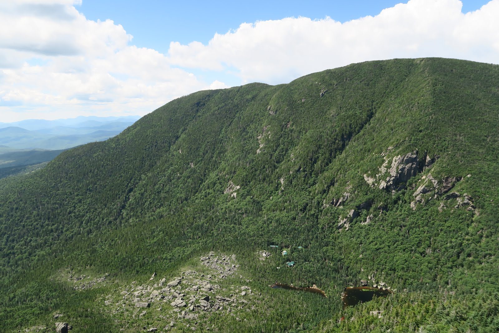
Lush green was so vive! We continued walking for another couple of miles towards the cliff. Under the cliff is ocean. Atlantic ocean is not my ocean, however, it is still nice to see it. (my ocean is Pacific ocean, because I am from Japan.) 


On the beach some people were walking and sitting, but it was not crowded at all. They were able to have long social distances. 

We sat on the cliff and ate lunch by looking down the ocean. Looking at the ocean for a while, we noticed that there are at least 10 seals swimming in the ocean. Mostly very close to the beach, but never land on the beach. Interesting! Even from the far away, I was able to tell they are cute. Next time we will check them out from the beach. 

Then we carried on walking. Then a problem came. The trail got very very narrow and it was inevitable touching plants. The trail was not maintained much. My immense concern was that there might be poison ivy in the plants. I or Mr.N can't really tell how poison ivy look like. We are familiar with poison oak, which habits Western half of the U.S., but not well with poison ivy. 

Because I am SUPER MEGA allergic to poison oak, I know that touching poison ivy will be a huge problem as well. The allergen to cause skin inflammation is urushiol, the oil contained in both poison oak and poison ivy. 

My nightmare flashed back. I had a handful experience of getting severe, 2 month lasting lash from poison oak in California. 

Due to that, we had to head back to the trailhead. On the way home we bought Tecnu. This is the only effective preventive method to maximize the potential not to have rash and inflammation from poison ivy/oak.
As an immunological point of view, urushiol, the oil from poison ivy/oak is first absorbed by skin. Urushiol itself can't provoke any immune responses. However, once urushiol binds to protein in the skin, it will provoke immune response. Once immune system memorize those molecules, next time you will get strong immune response, which is rash. Now I have established the immune response, it is inevitable to escape from that. Tecnue is basically a solvent for oil. By rubbing Tecnue lotion on the skin, it can dissolve urushiol into the Tecnue. Then wash out the Tecnu. By doing that minimize the urushiol contents to bind to skin proteins. For urushiol to bind proteins takes 8-10 hours, so it is important to wash with Tecnu by end of the day is essential. 

Tecnue is sold at any pharmacy like CVS or Walgreen. If you are a hiker, it is good to have it at home. This immune response is established in anyone, at any age, at anytime!

Luckily I didn't get any rashes this time. Phew. 

週末にケープコッドへちょっとしたハイキングへ。
ケープコッドはマサチューセッツ州の南東部にある半島。ビーチがたくさんあり、ハイキングもできる。バイク(自転車)用のトレイルもあるし夏休みの行き先として人気な場所だ。ここは国立海岸として保護された公園になっている。

お金持ちの人は休暇用のバケーションハウスとケープコッドに持っている人も多い。夏にケープコッドに来る人は多いもののハイキングする人は少ない。ほとんどの人はビーチで寝そべったりレストランに行ってホテルに何泊かするというパターンだ。我々は違う。通常の年は夏は人が多いので春秋冬にハイキングに行く。しかしコロナウイルスのため今年の夏はケープコッドも閑散としているということでハイキングへ行った。

緑が生き生きとしている森を歩いて行く。綺麗な森で誰もいない (1枚目の写真)。5キロほど歩くと崖の上に出る。そこからは海が見渡せる(2枚目の写真)。そこでサンドイッチを食べた。海をみているとアザラシが泳いでいるのが見えた。10匹以上はいた。次回はビーチに行って近くで観察してみたい。

その後さらに歩いて行くとトレイルがどんどん狭くなり植物が足にあたるようになった。ここで問題が。。。ポインズンアイビーに触れると私はひどい皮膚炎を起こしてしまう。ポイズンオークとポインズンアイビーにはウルシオール(漆のオイル)が含まれていてそれが免疫反応を起こすのだ。ポイズンオークはすぐにどれだかわかるのだが、ポイズンアイビーはいまいち見分けられる自信がない。ということでそこでハイキングを中断してトレイルヘッドに引き返した。家に戻りテックニューで腕と足を洗う。これはウルシオールを洗い出して免疫反応を抑えるローションだ。もちろん時間が経ってしまえば完全にオイルが吸収されて免疫反応が始まってしまうので意味がないが8時間以内に洗えば通常は免疫反応を抑えることができる。5−6回ポイズンオークでひどい目にあっているので今回は3回テックニューで洗った。おかげで皮膚炎が出なかったのでかなりホッとした。綺麗な景色だったがポイズンアイビーが生えているかもしれない疑いで忙しい日となった。。。


2020-07-26

Backpacking in Nash Stream Forest

On sunny weekend in July we went backpacking in Nash Stream Forest Area. This time a little hardcore schedule.


<Overnight Backpacking>
Trailhead: Crawford Notch Road (302) and Notchland Road
Total mileage: 21.82 miles
Elevation gain/loss: 5,869 feet

Route: Trailhead-Davis path - Mount Davis -Mount Isolation -Rocky Branch Trail- Stairs col Trail- Davis path-Trailhead

Type: lollipop (first potion is out and back, then loop)

Mount Davis

Due to relative long distance per day, Mr.N suggested leaving Boston at 4 a.m. Four. That means that we needed to get up at 3:30 a.m.! We arrived at the trailhead around 7 a.m.  Surprisingly there are more than five cars already there in the parking lot. The first 4 miles was repeat we did before with a hiking club. It was funny I didn't remember at all about the steep uphill portion for the first 3 miles, but I remembered very well after the point it got to the ridge and much less steep. I have heard that human brains eliminate unpleasant memories, and I thought that this was a good example. At mile 8, we went up to the first mountain summit, Mount Davis. This is a 0.2 mile steep spur trail from Davis path. It was worth taking an additional mileage. 

Mount Isolation

Then next was Mount Isolation. This backpacking can have multiple mountain summits, which is a bonus for long distance backpackers. Mount Isolation is a 0.1 mile spur trail. Again this was worth the stop. I wonder the name of the mountain was because it is isolated. Even now this summit is 6 miles from the closest trail, which is relatively long side compared to other mountains in New England.  

Sign!
camping spot

Then we headed for the campsite. It is a primitive campsites on the first come first serve basis. We hoped that there would be space and also would hope water source. We were not sure where exactly the campsites were, but we found a small sign on the trail (right picture). There were some flat spaces and luckily there were no one at 4:30 p.m.  We took the largest flat spots and started campfire! My favorite activity. There was already a big fire ring. The trail was muddy and the all logs on the ground was wet. Due to the wetness, it was hard to start the fire. 

Later after 6 p.m., group of 5-6 came asked us if there was more further our spot. We said no.  Looked like they were jealous about our spot. They had to take smaller, uneven spot. Early bird gets the worm! Those people pitched the tent over the some bush/trees of our site. I heard they had marijuana and got chatty. Luckily they went to bed as early as us and got quiet.  They seemed to fail to start the fire, that might be the reason they went to bed early. Also Mr.N heard that they were talking, "The hike was so hard. I don't know if I can go back tomorrow." That might be another reason they got quiet early. Good!

Pretty fall

Next day the first 2 miles was soooooo muddy! Grrr. I assume all the mud came from a lot of rain during the week. It was tough to hop on rocks no to get stuck in the mud, however, the bright side was falls were pretty (left picture). There are not many falls of this type (wet, mossy, hidden) in the West. This type of falls are usually in the forest and it always reminds me of Zen, from a viewpoint of Japanese. The beauty presents deep inside of these scenery. 

Cairn

After 2 miles, we hiked on a most isolated trail, rocky branch trail. Most people go to mountain summits in a shortest way. The Rocky branch trail, which is full of rocks and branches actually, is not the trail for any mountain in a shortest route. We indeed didn't pass anybody in the entire rocky branch trail. I really liked the rocky branch trail, not only isolated, but also trail was rather well marked. There are many river crossing, and it was marked as a cairn (the picture in the upper right). Sometimes two cairn was found in the opposite direction, that is often happened on the abandoned trail. The trail finding was fun. 

5,869 feet elevation gain and loss was hardcore, but it was a good one. 

2020-07-12

Kayaking on Blackstone river/Great Meadow

More social distancing! Kayaking on the weekends. 

First one is blackstone river and canal. This is in central Mass. Blackstone river is a very shallow, and quiet river. "Nice!" I thought at first. Then, 0.3 mile of kayaking, we had to land, carry kayak on the stairs to walk over the dam. Grrr. This was a tough part. The kayak is heavy on the stairs. For sure it was a good training for arm muscle. 

Quiet Water

Other than that, the kayaking was nice.  The water was extremely calm and quiet. It was a sunny day without winds, meaning perfect for kayaking. One challenging part was that the water was too shallow sometimes and had to find a way for a deeper water portion. It was an adventure. 

Below 2 pictures are nice red-winged blackbird and a heron. Nice to see them. More kayaking, I have more opportunities to see red-winged blackbirds. Then more and more convinced that blackbirds are real bullies. They chase big birds aggressively. I saw they chased away herons, who are at least 5 times bigger than them, and also chased away hawks. It is funny. 

Flowers for sure

A couple of weeks later, we went kayaking on Great Meadows National Refuge. We had kayaked in the Great Meadows before, but we did a different portion this time. Now we saw flowers that were not bloomed last time. They are flowers for sure, but I don't know what flowers (the left picture). Please let me know if you know! Nice purple ones.

Canada Geese
Clouds formed

Then a Canada geese family! A couple of weeks ago we saw a Canada geese family, but that time babies were much much smaller. However, this time babies were almost the same size as mother! Wow. Only evidence they are babies of the mother was following mother. Probably they need to move to south where there is no winter, so babies need to grow quickly. Long journey ahead for them. After a few hours of kayaking, we saw thunder clouds formed and heard thunder in the distance, so we kayaked back to the starting point and left. 

Relaxed kayak!

2020-06-27

Backpacking in Sandwich Range

Getting away from hot humid Boston for weekend is good. One weekend in June, we went backpacking in the Sandwich range in New Hampshire. 

First picture was Lady's slipper. I learned the flower's name after I got home. It looks like a lady's slipper....may... be. We saw pink ones and white ones. White one is interesting, because their vessels were seen in pink. It looked like blood streams. Both look pretty and vulnerable. Seeing something time-sensitive stuff is grateful. 

Somehow it was hard to focus on Lady's slipper. It took some time to get nice focus on the flowers. We behaved like Mr.B3. He is a photographer, and loves taking wild flowers, especially in Montana. Mr.N said that he might text these pictures to make Mr.B3 jealous. 

viewpoint
sunset is approaching
sunset

After a couple of hours, we reached the planned camping area. Hiking book indicated that there might be some some camping spots near Mount Paugus. The west side of summit there was a party already set up a camp, although we didn't see it because the site was in the trees. We noticed that some human voices and smell of campfire. We searched a potential flat space that is big enough for one tent. We found it in the east side of summit. It was just 10 seconds for a great open view point, but our site is protected by trees. It was perfect! Now in June, daytime is long is sunset is late. That means that there is enough time to see sunset, even though sunset is earlier in the mountains. We went to the viewpoint and waited for the sunset. The right picture is again from the same viewpoint, but due to the light direction, it looked like a totally different place. It was beautiful scenery in the warm orange sunlight. 

viewpoint in the morning

Then we observed sun setting. It was nice to see sun go down to the ridge line. Somehow clouds formed one straight line and sun set could be seen between the cloud line and ridge line. After the sunset we enjoyed campfire, dinner, cookies, tea, then slept. In the morning, again we enjoyed campfire. After breakfast, we took down the tent. I took several pictures at viewpoint for the final look before going down. It was nice to stay near the viewpoint, because i enjoyed many different beauty at the same place.