2019-04-30


2019-04-28
Mount Jackson Day Hikng
We climbed another peak, Mount Jackson, which is one of the mountains of the Presidential range in New Hampshire.
 |
At the trailhead |
As you can see in the left picture at the trailhead, it is 2.6 miles to the summit of Mt. Jackson. Elevation change is about 2100 feet. It is not too long and not too much elevation gain. It is good for winter day hiking.
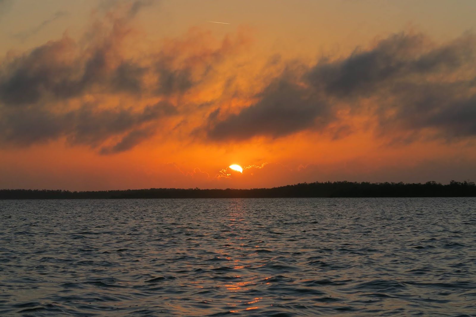
We hiked here at the end of April. However, it is still in the snow in White Mountains. Indeed it snowed a day before.
 |
Near the trailhead |
First 1.4 miles until junction is not much covered with snow. Mostly there is monorail, which is hard snow portion made by hikers in the winter. So we hiked with microspikes. You can get an idea from the picture in the left. Around the monorail is muddy and snow is melting. Monorail portion is melted last. Actually it was better to walk on the monorail, otherwise it is muddy or you will posthole.
Stream with brown water |

The first 1.4 miles, it will cross stream several time. One point, the biggest one had brown water as left picture. It might be melted snow from a day before. It was icy on the rocks near the stream, so I crossed carefully.
 |
Snow Forest |
Then after the junction at 1.4 mile point, the forest was getting more covered with fresh snow from previous day. It got much more quiet and I felt like I was in the deep snow forest. I love trees covered with fresh snow. It is beautiful.
When I was looking at pretty trees, suddenly a dog appeared ahead. The doggy ran to us and wagged tail and barked. Then the dog was called and ran ahead again. It was a hiker's dog ahead. I really like to see excited doggies on the trail.
 |
Last part to the summit |
Then pleasantly trail is getting steep and finally get out of tree line. From here, it was very windy and cold. It was only around 0.3 mile to the top after passed tree line.
The last part is rocky and icy. It was a little tricky, but not bad. On this day, the top was in the clouds, so not really open view, but still nice feeling to stand on the top. This is my third peak in the Presidential range (Washington, Madison, and Jackson).
 |
| Near the summit |
In the summit area, I saw many ice hanging from branches. It was pretty.
On the trail we saw 3 parties in addition to us. It was always nice to see some happy hikers and dogs, but it also nice in winter not too many hikers, because I like to be in the wilderness peacefully.
Near the summit |

To be honest, I got disappointed when I saw clouds on the mountain tops in the area at the trailhead, but it turned out to be a nice hike.
4月末のとある日曜日にジャクソン山へ登った。 ジャクソン山はニューハンプシャー州にあるプレジデンシャル山脈にある山のうちの一つだ。プレジデンシャル山脈は歴代のアメリカの大統領の名前がそれぞれの山に付けられている。ジャクソンもアメリカの大統領だった人だ。
最初の写真はトレイルヘッドにあるサイン。ジャクソン山までは2、6マイル。約4、2キロ。行き帰りで8、4キロ。上りは2100フィート(640メートル)。
4月末といえども前日に雪が降ったりとまだまで山は雪の中だ。
まず最初の半分は雪が溶けてぐしゃぐしゃに泥になった部分とモノレールと言われる冬の間にハイカーに踏み固められてレールのように残っている部分とでトレイルは成り立っていた。モノレールの周りにも多少雪が残っている。この周りの柔らかい雪を歩くと”ポストホール”といって足が膝ぐらいまでズッポリ雪の中にはまってしまうことが多い。雪が溶けて柔らかすぎるからだ。なのでこの時期はこの踏み固められた部分のモノレールを歩くのが安全だ。もちろんマイクロスパイクは必須。
さすがに4月末になっただけあってトレイルヘッドの近くでは小川が流れていた。前日の雪の影響下水は茶色だった。
そしてさらに登って行く。勾配は徐々にきつくなっていく。それとともに前日の雪に覆われた雪の森の中へ。木はフレッシュな粉雪に覆われてとても綺麗。静かで綺麗な雪の森(4枚目の写真)。すごくいいハイクだ。
そしてさらに登りやっとツリーラインを超えた。そこからは強風。その中凍った岩を登っていく(5枚目の写真)。やや大変だったがこの部分は0、5キロ程度だったので難なく終了。そして頂上。うーむ。この日の頂上は雲の中だったため特に景色を見渡せたわけではなかったがやはり頂上に着くというのはいいものだ。
頂上近くでは木に付いている氷や雪の形が綺麗だマクロの写真をとった。厳しい雪の中にある美しさがいい。
正直、トレイルヘッドで山の頂上辺りは雲の中というのがわかった時は若干がっかりしたが、意外にも雪の森や雪の中の木の氷が綺麗で満足のいく俳句になった^^
Florida Biscayne National Park Day3
On the final day in Biscayne National Park, I had an amazing experience. I saw manatees!
Manatees are sea mammals, sometimes they are called sea cows. They habitat in the warm sea around Florida and more south. They are vegans.
We asked the canoe renter where manatees are often seen, and canoed from near Visitor center to those frequently spotted places. The person said that manatees are often seen near cannal.
After canoeing around for half an hour, we saw 3 manatees swimming together! They were indeed near the cannal. Two adults and one small kid were swimming together. WOW. They are so cute! They swim very slowly, so it was possible to canoe around manatees for around 10 minutes. Manatees surface for breath, so it was visible from canoe that they were swimming. I didn't bring my camera for this canoeing, so there is no picture, but it is in my memory. So exciting.
After finishing canoeing, we had lunch while observing pelican catching the fish. 

Then we headed for the airport. It was a wonderful trip.
ビスケーン国立公園3日目、そしてフロリダの旅最終日。
この日はとても思い出に残るカヤックをした。なんと!マナティーを見たのだ!超ウルトラ楽しくエキサイティングなカヤックだった。
マナティーは海の中に住む哺乳類で、アメリカ合衆国ではフロリダでしか見られない。見た目は象みたいな可愛い動物だ。海の中で海藻・植物を食べる草食動物だ。水中で息はできないのでイルカと同様に水面に上がって来て息をする。
ビジターセンター近くの海ではマナティーがよく出没するとのことを聞き、早速カヌーを2時間レンタルしてマナティーを探した。そして、、いた!!!!!!!
マナティーが3匹一緒に泳いでいる!わー。2匹の大人と1匹の(多分)子供。マナティーは動きが遅いのでカヌーとほぼ同じ速さで泳ぐ。可愛い!ものすごくかわいい!
マナティーを近くで見ることができ、なおかつ、10分程度近くで”一緒に”泳ぐことができたのは一生の思い出だ。
そして空港に旅立つまでの間、フロリダの海をピクニックしながら眺めた。ペリカンが海にダイブして魚を捕まえていた(写真)。華麗かつ計算し尽くされた見事な狩りだ。
フロリダを去るのはとても名残惜しいものだったが、十二分に満喫した思い出の旅となった。また次の旅が待っている。
2019-04-27
Florida Biscayne National Park Day2
 |
| Elliot Key |
On the second day of Biscayne National Park, we went to Elliott Key to camp overnight. We took an early morning boat and arrived there around 10 a.m. There were already many motor boats were docked at the bay. Normal people (not hikers obviously) have chairs and barbecuing or just sitting. It seemed like Elliot Key pier area is for normal people with motor boats.
For us campers pitch tents farther from those area. After we pitched a tent, we headed for hiking in the forest.
Florida is a tropical area. So there are many forests. That means it is a paradise for mosquitoes. As soon as we started walking one hundred of mosquitoes were flying around me. I am not exaggerating. So many mosquitoes were there. Even I had DEET all over the clothes. I didn't have any skin exposures. I had mosquito net on my head. The noise they made was annoying, so we decided to hike along the ocean where not many mosquitoes due to breeze.

 |
| Vase Sponge |

It was very nice to walk along the ocean. I saw many fossils of coral and sea sponges. On the previous day I saw many kinds of coral in the ocean, and then saw many kinds of coral fossils. I felt the long-term nature cycle.
I also saw Florida specific plants that can get only water portion without sodium chloride from sea water. I thought it would be a great business if I can invent the way to do that easily for sea kayaking trip, long fishing trip, or canoe trips.
At night the motor boat people got crazy and partying with fireworks. Well, Elliot Key is not a good spot to camp peacefully, but it was an experience. Hiking was quite interesting here.
ビスケーン国立公園2日目。
この日は朝ボートに乗りエリオットキーへ。エリオットキーはフロリダキーの中でも有名。特に北部のキーの代表格だ。
エリオットキーに着くとすでにたくさんのモーターボートが沖に横付けされている。そしてたくさんの家族がバーベキューしたりピクニックチェアに座ったりしてリラックスしている。どう見てもハイカーはいない。
うーん。どうやらここはウィルダネスキャンプグランドという感じではない。まぁ仕方ない。これも経験だ。我々はまずそれらの”普通の”人々から離れたところにテントを張った。そしてデイハイクへと森林の中へと歩いていったのだが、ここで大問題発生!蚊がすごすぎる!この世で一番強力な虫除け、DEETを全身につけ、蚊ネットをかぶり、長袖、ロングパンツ着用ですら、蚊が身体中に!200匹はいただろう。大げさではない。フロリダの蚊は12月ですらすごいことを思い知らされた。森林の中にはいられない、ということで海岸沿いを歩くことにした。風があるので蚊はいない。ふぅ、やれやれ。
海岸沿いを歩くのはすごく興味深いものだった。キーというだけあって、そこら中にたくさんのサンゴ礁の化石が。ブレインコーラル、ベースコーラル(下から2枚目の写真、ベースは花瓶の意味。花瓶のような形をしているから)。
そしてフロリダ特有の植物(一番下の写真)。この植物は海水を吸い上げ、塩を吸収せずに水だけを取り込むことができるのだ。この技術を用いれば色々役立ちそうだ。
夜はモーターボートで来ていた”普通の”人たちが花火をしたり大声で喋ったりして静かな夜とはいかなかった。ここでキャンプするのはあまり得策ではない。しかし、サンゴ礁は蚊の大群を体験できたのは良かった。
2019-04-26
Florida Biscayne National Park Day1
Biscayne National Park is a relatively new National Park in south of Miami, Florida. It was established in 1980. So this park is "young" among American National Parks.
When we decided to go to Florida for Christmas, I wanted to go to both Everglades and Bicayne, because both look unique and interesting.
Biscayne has keys, which is made of coral reef.
Yes, Biscayne's feature is coral reef.
I had never heard of keys (except for meaning as door keys) or coral reef. It was very interesting to me.
On the first day at Biscayne, we joined Ranger talk and I learned about keys and coral reef in the area.
 |
| Brain Coral Fossil |
Florida keys are very long: from north where Biscayne National Park is located to all the south to Key West. Keys are the exposed coral reef due to a drop of sea level.
The picture in the left is brain coral fossil. Wow.
I know that people like to go to Key West, because it is southernmost point in the Florida. However, I didn't know what the key meant. I was glad that I attended the ranger talk.
Then in the afternoon, we joined the snorkeling tour to see coral reef in the sea. It was a great timing after learning about coral reef. The tour is held regularly by Biscayne National Park Institute. This is a non-profit organization and offers boat tour/snorkel tour in Biscayne National Park. Because it is NPO, the price is not expensive. Also the guys are very informative.
The boat took us in the middle of nowhere of the keys and we jumped into the sea.
In the ocean, there are millions of kind of coral are there! So many colors are living there. Pink, red, green, yellow, orange, blue, brown, grey, black, purple...it is more colors than I can describe with words. Then, there are also colorful fish eating coral and resting in the coral.
I had never imagined that there would be such colorful world under the sea. I didn't have a water camera at this trip, so I don't have pictures to post. Even if I had possessed it, it would have been hard to capture the undersea coral world. The Florida coral world is amazing.
It is already great to see the Florida ocean, but it was really nice to go in the sea and see the massive coral.
フロリダにあるビスケーン国立公園は1980年創立の比較的新しい公園だ。クリスマス休暇にフロリダに行くのを決めた時、エバーグレーズだけでなくビスケーンにも是非行ってみようと思っていた。
ビスケーンの一番の特徴は、キーだ。キー(鍵としてのキーは聞いたことがあったが)というコンセプト自体知らなかったので、キーについて学び体験することができてよかった。
午前中はレンジャートークに参加してキーについて学んだ(レンジャーは国立公園いいるスタッフ)。
フロリダキーズ(フロリダ礁島群)は長い。北はビスケーン国立公園からアメリカ最南端のキーウエストまで続いている。キーはサンゴ礁が海の表面に出て来たことによって島になっているエリアのことだ。海水レベルが下がったためにサンゴ礁が表面に出て来たというわけだ。
午後はスノーケリングツアーに参加した。このツアーはビスケーンインスティチュートという団体によって行われている。この団体は非営利団体で唯一ビスケーン国立公園でツアーをできる団体だ。非営利なので料金もリーズナブルで安心。またボートのスタッフは色々ビスケーンについて教えてくれ学ぶこともできる。
ボートで海を渡り、その間スタッフがビスケーンについてのレクチャー。そしてキーの近くの海のど真ん中でボートが止まった。わー。ここで海に入りスノーケリング。
海の中には。。。何万ものサンゴ礁が。色々な色!ピンク、赤、緑、オレンジ、青、茶色、グレー、黒、紫、、、、と言い表すに足りない様々な色、色、色。。そしてその周りにはこれまたカラフルな魚、魚、魚。。。泳いだり、休んだりしている魚たち。
こんな世界が海の中にあろうとは想像もできなかった!すごいの一言だ。もちろん海を眺めるだけでもフロリダではいい旅だが、海の中のサンゴ礁を見ると新たな世界が広がる。本当にすごかった!
2019-04-25
Florida Canoe Backpacking in Everglades Day5
The last day of canoe trip in Everglades. This day we left the South Joe River Chickee around 5 a.m. Again it was dark, but quiet and peaceful. The guy on the chickee was awake, so we said goodbye and headed for Flamingo.
 |
| Sunrise |
This day had more waves, but I could also contribute to paddling because of the rest day on day4. It was nice to see sunrise in the bay. I had never seen sunrise on the water. This is truly a wonderful experience.
 The last part to Flamingo was canal. Along the canal, we saw alligator.

For my first canoe trip, I had fun and sore arm. Next canoe trip I will try more hardcore one.
We put the canoe to a car and drove back to the hostel to return it. The hostel was so nice and let us use outside shower. It was great to have a hot shower after a week of no shower and getting salty winds. We rented a canoe for 5 days and they charged for 4-day price.
Then next day we went off for Biscayne National Park.
この日はカヌーキャンプの最終日。この日はサウスジョーリバーチッキーを5時に出発。早っ。しかし、朝早くが一番潮の流れ的に漕ぐのが楽なのだ。やはり流れに反して漕ぐのは辛いので、朝辛くても早く出発する方が得策だ。
この日も出発時は真っ暗。しかし少し漕ぐとあたりがわずかにオレンジに染まってきた。そして日の出。日の出を海の上から見た。人生の中で日の出を海の上で見ることはそうそうないだろう。それを経験し、そしてその美しさに感動できる、というのはありがたいことだと思う。
海は波が荒かったがこの日は2人で漕いだのでなんとか乗り切ることができた。前日はMrNが全て漕いだおかげで私は休息することができたので、最終日の波が荒いところで漕ぐことができた。このストラテジーは良かったと思う。MrNに感謝。
最後の1マイルほどは運河を通ってスタート地点のフラミンゴを目指す。ここのカナルでワニが!わー。トロピカルの気候は見れる動物もぜんぜん違う。楽しい。
そしてスタート地点に戻ってきた。5日間のカヌーキャンピング、初めての経験づくしで楽しいものとなった。
カヌーを車の上に括り付け、レンタルしたホステルへと返却しに行った。ここのホステルはすごく良心的。なんとタダで外にあるシャワーを使わせてくれた。5日間シャワーを浴びていなかったので、相当さっぱりした!!!そして5日間レンタルしたけれど、4日間のレンタル料でオーケーとのこと。ここ、おすすめ。
そしてエバーグレーズ国立公園を満喫した後は、同じくフロリダのビスケーン国立公園へと向かったのだった。
2019-04-23
Florida Canoe Backpacking in Everglades Day4
This day we started really early. It was 5 a.m. in the dark. We started canoeing. Well, only Mr.N was paddling, because my arm was too sore to paddle. It was very nice to see the whole world getting light little by little. Such early morning nobody was out there. Just us on very calm water. How peaceful.
 |
| Sun is rising |
Mr.N was a little concern about only him paddling for a day. However, it was not a problem. It was really calm this day and around 11 a.m., we already arrived our destination, South Joe River Chickee. We were just chilled on the chickee. The view from South Joe River Chickee was amazing. It was quiet and peaceful. Sometimes dolphins swam from north to south. They jumped joyfully.
 |
| From South Joe River Chickee |
In the afternoon, a kayaker came to the chickee. We shared the double chickee. He lives in Florida and a nurse. He has a nice person. We had extra water, so I gave him one gallon of water.
 |
| sunset |
 In the evening, we ate Japanese udon (instant cup noodles). I never eat cup noodles on normal days, but I do occasionally during camping. Anything is tasty at camping.

After seeing gorgeous sunset from campsite, we went to bed. The next day we would leave the chickee again early due to tide.
前日にちょうど同じチッキーでキャンプしていた人達から、朝早くが潮の満ち引き的に一番ラクということを教わったので、朝の5時にはすでにカヌーを漕ぎ始めた。暗い中カヌーを漕ぐことになるとは。。しかし、カヌーの上で徐々に朝日が昇ってくるのを見るのはものすごい経験だった。とにかく素晴らしい。朝日が水面に写りあたり全体がオレンジ色に染まっていく(写真1枚目)。それを静かな水面で見ている。あたりに響くのはパドルで漕ぐ水の音だけ。こんなすごいところにいれるなんてラッキーすぎる。
私は前日かなり腕が痛くなってしまったので、MrNが一人で漕げるところまで漕ぐことになった。MrNは一人で全行程を漕げるか心配していたが、なんと11時には目的地のチッキーに着いた。わー。この日はリラックスできる!チッキーにテントを張りテントから外を眺めているとイルカが!5−6匹でチッキーの北側から南方向へと泳いでいく。可愛いーーーー!そして私に挨拶するかのようにチッキーの近くでジャンプ!フロリダのイルカは遊び心がある。
そして早めの夜ご飯。この日のディナーは赤いきつね (写真3枚目)。ジェットボイルでお湯を沸かし注いで3分。普段はカップラーメンなど食べないが、カーキャンプやカヤックキャンプの時は時々食べる。家でカップラーメンは食べたくないが、アウトドアだと美味しい!
チッキーはダブルチッキー(昨日のポストを参照)で反対側のチッキーはもう一組のグループがキャンプする。この日はフロリダ在住の看護師をしている男性のカヤッカー。フレンドリーなナイスガイだ。カヤックでのキャンプも楽しそうだなと思った。我々は水が余っていたので1ガロン彼にあげた。
そして!ここから見る夕日がまた格別だった。静かな水面。静かにオレンジ色の夕日が沈んでいく。あたりは静寂に包まれ、本当に貴重な景色を見れた。そして次の日も朝早くが潮の流れとして一番漕ぐのが楽なのでまた早々に寝ることにした。
2019-04-22
Florida Canoe Backpacking in Everglades Day3
日本語は英語の後にあります。
This day we left the ocean coast line and turned into the inner side. We canoed into Shark River, then to Oyster Bay. We were new to this area, so we didn't know the tide pattern. So apparently we were paddling during hardest time, meaning going against the tide. One point on the Shark river, I took a break from paddling, because my arms hurt from the previous two-day paddling. When I stopped paddling, Mr.N ordered, "Paddle it!" I said, "My arm hurt!" I literally paddled until my arm really hurt. After waiting a minute, I paddled again, but my arm even got hurt more, so I got to the point I couldn't paddle anymore by the time we arrived the day3's destination. It seemed that the next 2 days Mr.N would have to paddle by himself...
On the inner sides, of course there are no beaches to camp. Also Any small lands are too muddy to camp. Due to that, there are platforms to camp, which is called chickee. Chickees are shelters with roof, but without walls. They are used native people in Everglade area. Now chickees are used in Everglades National Park for campers. The photo below is a double chickee. Two parties can camp at this chickee. A porta-potty is shared with two parties.This is quite interesting and unusual experience.
chickee |

Dolphin |

On the way to the chickee on the ocean, in river, in the bay, we saw many Florida dolphins! It was very exciting. When they saw me, sometime them jumped and spun as if they were happy to see me.
At the double chickee, next party was two females. They were doing 10 day canoe trip on wilderness waterway in Everglades. They had done it before, and had canoed in Florida a lot and knew very well the area. Mr.N asked about the current and when was the good time to go the next morning. They kindly taught us about the current this area. Furthermore, they gave me a map with current. Very nice of them. It turned out very early morning is the easiest due to the tide. So we went to bed early.
カヌーキャンプ3日目。この日は海から内部の入江部分へと入る。シャークリバーを通りオイスターベイへ。我々はフロリダも初めてだし、このエリアに来たのも初めて。なので、潮の満ち引きのパターンを知らない。どうやら我々、潮の流れに逆らって一番辛い時に逆方向にカヌーを漕いでいたのだ。 はー。だからこんなに疲れたのかと後から気づいた。しばしの間漕ぐのをやめて休息しようとしたらMrNに漕ぎ続けるように言われたほどだ。
疲れたが、すごくエキサイティングなことも!フロリダイルカをたくさん見たのだ。ジャンプしたりスピンしたりすぐ近くで見ることができた。ものすごく可愛い。最高。2番目の写真はジャンプした後のイルカの写真。
海から逸れて中の川の部分ではキャンプできるようなビーチも陸地もない。写真では小さな島があるように見えるかもしれないが、単にマングローブが生えているだけで陸はないのだ。というわけで、キャンプする場所はチッキーと呼ばれるプラットフォームになる(写真1枚目)。最初グーグルでこれを見たときは、えーっ!と思い、実際見て見るとさらに、えーっという感じだった。両側に屋根があるのがわかる通り2グループがキャンプできる。そして中央の簡易トイレを2グループで共用するのだ。チッキーはこの地域にいるネイティブアメリカンの家屋のスタイルの名前。チッキーに泊まる経験がある日本人なんて相当少ないだろうなーなどと考えつつテントを張った。隣のグループは女性2人で10日間のカヌーキャンプをしていた。彼女らはこの地域の潮の満ち引きに詳しく、詳しく説明してくれただけでなく潮の動きが載っている地図までくれたのだ。それによると次の日は朝早くが潮のパターンからしてベストなタイミングということで夕飯の後速攻で寝た。
2019-04-21
Florida Canoe Backpacking in Everglades Day2
日本語は英語の後にあります。
On Day2 we canoed to another beach camping spot, Northwest Cape. It is nice to canoe on the ocean. Sometimes go into the side mangrove rich area and took a break. One section in the inner portion, we stopped there and had lunch on the canoe. Mangroves are iconic and fits with Florida weather. Nobody was there and it was very quite.
 | |
| Mangroove |
Usually during backpacking, tiredness comes to my shoulder and legs. This time it was very different. All arms! I have strong muscles on legs, but not much arms. People say canoeing use whole body muscles, but for me it was mostly arms. Maybe it was because my paddling form was not good, or maybe because I have weak arm muscles. However, day2 was not very long day, so we were able to reach the beach way before sunset. Again, nobody was on the beach, so the beach was private.
 | |
| Sunset and Canoe on the beach |
 | |
| Amazing Sunset |
Seeing sunset on private beach....how luxurious it is! It is priceless.
One down side of Florida camping is bugs. Even in December, there are mosquitoes and no-see-ums.
Grrrrrr. ALL mosquitoes and no-see-ums bit only me. Actually every night I got 20-30 bites and Mr.N got ZERO! NONE for him. Definitely there are people who are bitten a lot and some get none. Those resistant people have benefits when they are with susceptible people. Mr. N got bitten only when I had Deet and he didn't. Unfair. Well, even though the bites, it is absolutely no doubt worth going canoe backpacking.
カヌーキャンプ2日目。2日目はさらに北上し違うビーチ、ノースウエストケープでキャンプする予定。 カヌーで海を渡るのは楽しくエキサイティングなアクティビティだ。漕ぐのに疲れて来た時ちょうど入江があったのでそこに入りしばし漕ぐのをストップして休憩。フロリダにはマングローブがたくさん生えている(1枚目の写真)。誰もいない静かな空間でフロリダの空気、植物、海を感じた。
通常バックパッキングに行くと、足と肩が疲れるのだが今回のカヌーはまったく違う。足は使わない。全部、腕!腕が疲れる。でも漕がないと進まない。2018年まで私はほとんど腕の筋肉のトレーニングをしていなかったので(今はしているが、トレーニングについてはまた別の機会に書く予定)、腕がかなり疲れた。しかしこの日はそこまで長距離を移動する予定ではなかったので目的地のビーチに日の入り前に着くことができた。
カヌーをビーチにあげて上下逆にして置き、テントを張って夕日を見た(2枚目と3枚目の写真)。この日もこのビーチでキャンプしていたのは我々だけ。またプライベートビーチ状態だった。ものすごい贅沢。こんな素晴らしいビーチでものすごい綺麗な夕日を見れるとは。。。感謝感謝。
ただ、一つ耐え難かったのは、蚊 とヌカカ(糠蚊)。2種類も蚊が。。。ヌカかは本当に小さくて見えないくせに刺されると猛烈にかゆい!!1日目、2日目と合わせて50個くらい刺された。なのに。。それなのに!MrNは一つも刺されなかったのだ。ゼロ。この日の夜から私は常に強力な蚊除け薬のディートを全身に塗ることにした。
2019-04-20
Florida Canoe Backpacking in Everglades Day1
This is my first canoe backpacking trip.
I went to Everglade National Park for Christmas vacation. I knew that a lot of East coast people go to Florida for winter vacation. So I looked up what there are in Florida. Then I found three National parks. Everglades is a good start to try. So I went there.
On the first day of trip, we flew to Fort Meyers. We arrived there in the evening, so just car camped that night at Big Cypress National Preserve.
The next day in the early morning, left the campground at 6:30 a.m. Then we rented a canoe at Everglade hostel. This hostel rent a canoe with reasonable price. Then we went to Flamingo Visitor Center at Everglade National Park. Luckily permits are available for each campsites/chickee.
Day1 of canoe backpacking trip, we started at Flamingo then started canoeing along the shore. Before this trip, I had canoed only once. That one was only 1 hour on the lake, not even canoe camping like this one. Only with 1 hour canoe experience, the second canoeing is 5-day canoeing. It was kind of aggressive.

I paddled at the front. A front person is not able to control the direction. In other words, a front person don't need to think about the direction: it is for me.
Compared to New England, Florida is obviously so warm. I was so happy being in the sun and staying warm. In addition to that, I am in the wilderness. That is more than everything I want.
The water is sometimes brown creamy, sometimes very blue. There are many mangroves. It is very different scenery from anywhere in the U.S. Not far from the trailhead Flamingo, we already saw alligator. Wow. Animals in tropical. It is very exciting doing canoe backpacking.

Day1 the paddling was not too hard, because of tide and winds. They helped a lot. This day we camped at East Cape. There are designated camping spots on the beach in Everglades. Of course literally there is no toilet or sign on the "designated" campsite beach, but still there are for National Park to track who are camping when.

It was amazing to see the big beach in a total quiescence. Nobody was there on the beach. The beach was private that day. We ate dinner while watching sun setting over the ocean. It was beautiful and peaceful.
色々な初めてづくしの旅!
2009年のクリスマス休暇にフロリダへ行った。今回はカヌーキャンプの旅だ。ものすごくエキサイティングな旅だった。
東海岸は西海岸に比べ、とても冬が寒い。ボストンもすごく寒い。というわけで東海岸の人のクリスマス休暇先で大人気なのがフロリダ。フロリダも一応東海岸で比較的ボストンやニューヨクからも近いし、そして何よりもフロリダは暖かい。トロピカルな気候だ。
フロリダに何があるのかよく知らなかったが、調べてみると国立公園が3つもある。これは行って見なければ!ということですぐ飛行機チケットを購入。
まずボストンからフォートメイヤーズへのフライト。夕方に着いたので近くのビッグサイプレスという公園で一晩キャンプ。次の日朝6時半にキャンプ場をあとにし、エバーグレーズ国立公園の近くにあるエバーグレーズホステルでカヌーをレンタルした。良心的な価格でとてもよい。機会があればここのホステルにもいつか泊まってみたい。カヌーを車の上に積み、とうとうエバーグレーズへとやって来た。まず、フラミンゴビジターセンターへ行き、カヌーキャンプするためのパーミット(許可証)をとる。公園内でキャンプするにはパーミットが必要だ。公園内のビーチキャンプや川に建てられているプラットフォームでキャンプできるのは人数が限られている。例えばプラットフォームでは1日2組しかキャンプできない。幸いにも我々の予定していた通りにパーミットを取ることができた。ラッキー。
私はカヌーキャンピングは初めての経験だ。これまでにカヌーは1度だけ1時間程度したことがあっただけだ(汗)なのにいきなり5日間のカヌーキャンプに挑戦した。MrNは私よりもカヌーの経験があるので、後ろで漕ぎ、私は前席で漕ぐ。後ろの人しかどの方向に行くかをコントロールできない。なので前の人はただひたすらパドルするのみ。
トロピカルな気候で12月というのに夏のようだ。−20Cのボストンから来た身にとってはパラダイス!トロピカルな気候と青空、青い海を満喫した。
1枚目の写真にあるように海は時々クリーミーにもなる。そしてそのクリーミーな表面にワニが登場!ワーーーーーー。すごい。気候の違う場所での動物は全然ボストンとは違う。楽しい。
そして1日目のカヌーはそこまで長く予定していなかったので、ほどなくキャンプ地のビーチへ到着。この日このビーチに泊まるのは我々だけ。プライベートビーチだ(3枚目の写真)。夕日を見ながらラーメンを作って食べた。夕日はとても綺麗だった。そして何よりも静かで美しいビーチに一晩入れたことに本当に感謝。
2019-04-19
Fall Color Hike in Squam Lake
Fall Colors in New England is very famous.
Indeed, fall colors are beautiful in New England. I went hiking in New Hampshire in October. I hike up the hill to see fall colors and Squam Lake. 

Orange, red, and greens are mixed. New England has many many trees. They turn fall colors almost at the same time, so it is always stunning. This kind of fall colors can't be seen anywhere else. There are not this many trees except for New England. If you don't live in New England, it is hard to make a trip on the right time, because peak of fall colors is different every year. Autumn color on the hills is nice, but also colors with lake is nice.

I like Squam lake.
First time I went to Squam lake is two years ago. My former boss has a vacation cottage along Squam lake and he invited me. Such a cute house along the lake. The lake is blue and pretty. There, I swam and canoed. It was fun.
After I moved to New England, I had day hikes near Squam lake. There is a mountain range called Sandwich range around the lake. I also kayaked on the Squam Lake. Lake is huge, so I need years to kayak everywhere of the lake. There are kayakers and canoers on the lake, but not many motor boats. That makes the lake more peaceful.
One more secret information about the town of Sandwich: there is a hidden ice cream place called Sandwich creamery. I like to stop here after hiking in Sandwich range. No one at the creamery. You get ice cream, you put money on the box. The ice cream is sooooooooooo delicious. It is "HBF"= High Butter Fat. My favorite is ram raisin, coffee, black raspberry.
ニューイングランドの紅葉は有名だ。少なくともほとんどのアメリカ人はニューイングランドの紅葉が綺麗といことを知っている。
昨年10月にスクアム湖近くの山に登り紅葉を見た。1枚目の写真にあるように、オレンジと黄色の紅葉が綺麗だ。ニューイングランドには木がたくさんある。これでもか、というぐらい本当に木が多い。その木が一斉に紅葉するのだから見所がある。日本の紅葉もものすごく綺麗だが、ニューイングランドの場合、木がびっしりと生えているため、オレンジの絨毯のような紅葉を見ることができる。ただし紅葉の時期はその年によって異なるし、いつがピークか予測するのが難しいので、ニューイングランドに住んでいない限り、ベストな紅葉を見るチャンスがなかなかない。このチャンスを生かして秋は(というか1年中だが)毎週末ニューハンプシャー州にハイキングへと出かけた。中でもこのスクアム湖の紅葉は綺麗だった。
最初にスクアム湖へ行ったのは2年前。私の前の上司(教授)の別荘がスクアム湖沿いにあり、そこへ遊びに行って一晩泊まった。その時は夏だったので緑の山々だった。ハイクし、湖でカヌーをした。
そしてその時、上司に秘密のアイスクリーム屋を教えてもらったのだ。サンドイッチクリーマリーというアイスクリーム屋。店、とはいうものの人はいない。アイスクリームを冷凍庫からとり、お金を箱に入れる無人の牧場にある小屋なのだ。そしてそこのアイスクリームが絶品。壮絶に美味しい。この近くにハイキングに来ると必ず寄る。ここのアイスクリームは”HBF” Hはハイ、Bはバター、Fはファット。高値バター+高脂肪の美味しいアイスクリーム。
もちろんこの紅葉ハイクの後もサンドイッチクリーマリーで合計5リットルほどのアイスクリームをゲットし、クーラーボックスに入れて家路へと急いだのだった。
2019-04-18
Mount Washington Day Hiking
Mount Washington is the highest mountain in New England (6288 feet, 1917 meters). It is the Presidential range in New Hampshire. Presidential range has mountains named former American presidents' names.
Because this is the highest peak in the New England, there are so many ways to climb up. By foot, driving, and little train. Of course I hiked up. I hiked up via Lion Head trail. This is called a lion head because there is a big rock seems like a head of lion. The trail is rocky, which is typical in New England. It is 4 miles to the top. It was not as long as I had expected.
These are the pictures at the top and looking at the top. The view is very nice. Because there is a road to drive up, many "normal" people are at the summit. There is a building and you can buy pizza, ice cream etc even. This is...well, different.


 As you can see in the left picture, train is also an option to come to the summit. It is expensive, but surprisingly, many people came to the summit by trail. I saw three trains came to the top during my stay at the top. It looks like a good business. You don't need state-of-the-art train like ones in Japan, but people pay anyway.

 | |
| Boott Spur Trail |
On the way back, I hiked down the Boott Spur trail. This is 1 mile longer than Lion Head trail. Due do that, there is almost nobody. Actually I liked it better. It was much more quiet and peaceful. I felt like it was longer than 5 miles, but sometimes New England mileage is wrong.
Many people have sticker on their cars saying "This car climbed Mt Washington". After seeing so many stickers on cars, I bought T-shirt that says, "
This car hiker climbed Mt Washington"
ワシントン山はニューイングランドで一番高い山だ。ハイカーでなくても知っている。ニューイングランドでは数少ない有名な山と言えよう。高さは1917メートル。それほど高くはないのだが、冬は豪雪に覆われるとともに、意外と危険な山である。実際、ニューイングランドでもっとも死者を出している山なのだ。ワシントンという名前から察しがつくように、これはプレジデンシャル山脈のうちの一つである(注:プレジデンシャル山脈は歴代アメリカ大統領の名前の山が連なる)。有名であるがゆえの宿命として、ハイカー用のトレイルだけでなく、車道が頂上まで続いている。そう、車で登頂できてしまうのだ。もちろん我々は足でハイクし頂上へ登ったが。そして、車だけでなく、列車でも頂上まで行けてしまうのだ。。(下から2枚目の写真)。
カリフォルニア、ベイエリアのディアブロのようなものだろう。車でも行けるがハイクでも登れる山といったところだ。
1枚目の写真が頂上からの景色。なかなか良い。さすがにニューイングランドで一番高い山とだけあって、全ての他の山を見下ろすことになる。雲も近い。近くに連なるプレジデンシャル山脈が綺麗だ。青空と緑の連山を満喫したと、今度は違うトレイルを使って下山した。ボットスパートレイルという長めのトレイルを選んだため、全く人がいなくてものすごく良かった。ニューイングランドの人は特に最短の距離のトレイルで登山・下山したい傾向が強い。
我々は静かで景色の良いトレイルが好きなのでここは正解だった。一番下の写真にあるように岩がどこまでも続くところを歩いて行き、そして下山した。
ニューイングランドにいるならばやはり一度はワシントン山に登るといいだろう。
2019-04-16
Holt Peak
Last weekend we went hiking to Holt Peak.
 First, as usual, we went to Haute coffee in Concord, MA on the way. A cup of coffee in the morning of Saturday is a good start of weekend. This place has great pour over coffee.

Coffee comes with beaker and warmed mug. The beaker is enchanting for me as a scientist.
Then we headed for a trailhead.
 |
| The sign at Trailhead |
To go to holt peak, we walked through Wapack trail, as you can see the sign in the picture left. This trail goes to North Pack Monadnock, where we hiked last weekend (wrote a blog here at https://himebackpacker.blogspot.com/2019/03/north-pack-monadnock-mountain.html). This Wapack trail connects Mount Watatic in Massachusetts and North Pack Monadnock in New Hampshire. Wapack is named after Watatic-North Pack.
Holt peak where we hiked this weekend is in the middle of Wapack trail. Just 4.6 mile out and back short hike with 1100 feet elevation gain.
Last weekend, the area was covered with snow. The entire hike we had to use microspiks. Now jut 7 days later, snow has melted a lot. The first half of the way to Holt peak was almost all snow free as you can see picture below.
In this picture you can see many New England-ish things.
First is a trail sign. Trail marks are on the tree in New England. I had never seen this in California. You can see yellow triangles on the tree. This matches with the mark at trailhead sign. The picture above, next to the letters of wapack trail, there is a yellow triangles. In that way, on the trail, if you see yellow triangles you know it is a wapack trail.
Next is a fence made of rocks. In New England, I see this kind of rocky fences a lot. They are from a long time ago for protection from enemies or boundary from neighbors. There might be a farm here. Then these fences are abandoned.
Another NewEngland iconic thing is rocky trail. Last portion of the trail in the picture, which is a little uphill, is rocky. A lot of trails are very rocky in New England. Due to this, same 1 mile is harder in New England, compared to California.
Finally, trees. There are many, many, MANY trees in New England.
 |
| Wapack trail to Holt Peak |
 |
| icy portion |
The last 0.5 mile to Holt peak was icy (picture in the right). We put our microspikes. Maybe next weekend, no need to have microspikds. The end of winter is actually tougher than middle of winter, because snow is icy and slippery. If snow is soft and puffy, it is easier to walk.
Then I thought that the trail reached the highest elevation, because I saw downhill forward. I asked Mr.N if it was the peak. Mr.N has an app AllTrails. He looked up map with GPS and said that that area was a peak. Ummmmm. I didn't expect that the peak was in the forest. Oh well. This is another New England thing. I looked around and found a small trail going side. I went there and found a sign of Holt Peak. Yay :) It was like a treasure hunt. The good thing now is there is space to sit down. Until last week there was all snow and no place to sit down and eat or take a break. We sat and had sandwich and banana. From next weekend we can sit down and take a break anywhere on the trail. I am excited about that.
 |
| Holt Peak |
There was a car at the trailhead when we came back. He had a dog in the car. He was trying to convince her to come out, but doggy was just looking at him and didn't come out. He said, "She is a little shy."
Maybe because we were here, the dog was shy to come out. The owner went to opposite door to convince her to come out. The dog still needed some time to come out, but finally started hiking. It was funny and the dog was cute.
On the way back, we got some sake (nigori) for today's summary and went home.
先週末はニューハンプシャー州でショートハイク。
まず朝はオートコーヒーに行き、コーヒーを楽しむ。ここのポアオーバーコーヒーがお気に入り。写真にあるようにフラスコのような容器で出てくる。そしてコーヒーカップももちろん温めてある。ハンドドリップで1杯ずつバリスタが作るのだ。フラスコには2杯分のコーヒーが入っておりゆったりとした時間を楽しめる。このカフェがハイキングの場所へ行く途中にある時は必ず立ち寄る。たまに、ここに立ち寄りたいがためにハイキングの場所を選ぶことさえあるくらいだ。
今回のハイクはワーパックトレイルからホルトピークへのアウトアンドバック。ワーパックトレイルはとても長く、前回は違う部分のワーパックトレイルを歩いた(その時のブログはここ
https://himebackpacker.blogspot.com/2019/03/north-pack-monadnock-mountain.html)
このワーパックトレイル、英語でWapackトレイルはマサチューセッツ州とニューハンプシャー州にまたがるトレイルでマサチューセッツ州のWatatic山からニューハンプシャー州North Pack Monadnock山をつなぐトレイルなので頭文字をとってWapackトレイルと名付けられたとのこと。
先週のワーパックトレイルは完全に雪で覆われていたが、たった7日後には随分溶けていた。マイクロスパイクすら必要なかったのだ。ニューイングランドもようやく0C越えする日が増えて来たようだ。3枚目の写真にあるように特に標高の低いところは完全に雪が溶けていた。
この写真、非常にニューイングランドの山の特徴を表している。
まず第一にトレイルのサイン。木に黄色の三角の印がついていのがお分かりだろうか。これがトレイルのサイン。2枚目の写真を見ていただくと、トレイルヘッドのワーパックのところに黄色の三角の印があるのが見えるはず。つまり黄色の三角の印があればそこはワーパックトレイルということなのだ。
第二の特徴は岩のフェンス。これはニューイングランドでよく見られる。昔ここに人が住んでいて敵のためか、家畜を飼っていて牛か何かがそこから外に行かないようにするためか、何らかの目的で作ったものと思われる。
第三の特徴としては岩のトレイル。写真の奥の方を見るとトレイルが岩でできているのがわかる。ニューイングランドの50%以上のトレイルは岩でできている。なので、カリフォルニアの土の1マイルよりも岩のニューイングランドの1マイルの方が疲れるのだ。
そして最後の1キロ。やはり標高が高いのでまだ氷と雪が残っていた(4枚目の写真)。そしてピークに着いた。。。模様。。。というのはトレイルの先が下りになっていたのでそこがホルトピークだと思われたのだが、森の中で何の景色も見えない。うーむ。少し歩き回るとホルトピークのサインが木にかけられていた。サインがないとピークとわからない。。。これもニューイングランドではよくある。
ともあれ、最後にトレイルヘッドで可愛い犬にも会えたし、よしとする。
2019-04-15
Mount Madison Day Hiking
Presidential range in New Hampshire is pretty. As the name indicates, there are mountains named after former presidents of Unite State. The most famous one is Mount Washington, which is the highest mountain in New England. However, Mount Washington can be reached to the top by cars or train. Due to that, the summit area is very crowded. Compare to Mount Washington, other mountains in the Presidential range is much more peaceful.
One day we chose to hike Mount Madison. Because I am not American, I didn't know Madison was the president of USA. Now I know. It is 5367 foot high.
 |
| Pretty: and yes, this is the trail |
 The total 11.5 miles and elevation gain was 4016 feet. We climbed via Madison Gulf trail. This is a tough trail to climb because it contains a lot of scrambling.

 |
| The point we finished the Madison Gulf Trail |
As you can see in the picture above and right, it is pretty with moisture rocks, and these are the trail, not along the trail! This kind of steep, wet, slippery, and rocky section continues very long. It is really pretty, and at the same tough. Due to this condition, we didn't see a single person climbing up via Madison Gulf trail. It looks like everybody climbed Madison from other side. It was hard, but I like peaceful trail and special thing, I liked this trail.
After Madison Gulf trail, there is a hut called Madison Spring hut. There are many people chilling inside and outside of the hut. Water is available for all hikers. I saw some people staying overnight there and doing short hike in the afternoon to the summit of Madison. It is only 0.4 mile for the summit.
 |
| Summit |
The view from summit was very nice. You can see many mountains in the presidential range. One on the south side is Mount Washington. I could see the car road and saw tiny cars going up to the summit. It was funny. Personally I liked Madison more, since only real hikers can be top, and much more peaceful.
On the way back, we took Appalachian trail. On the way we saw an AT hiker going uphill who is very fast. I saw some small camping spot apparently for AT hikers. The sites didn't look very scenic, more practical for literally just sleeping. It looks like very different from JMT. JMT hikers want to camp at scenic places.
I saw Mount Adams next to Madison on the map and looks interesting: now next destination was determined.
ニューハンプシャー州のプレジデンシャル山脈はなかなか良い。
プレジデンシャル:プレジデントの、という意味。プレジデントは大統領という意味。つまりこの山脈の山々にはアメリカの歴代の大統領の名前がつけられている。ワシントン山、リンカーン山、アダムス山、といった具合。その中の一つマディソン山へ登ってきた。高さは1636メートル。トータルで18.5 Km, 1224メートルの上りだ。 上りはマディソンゴルフトレイルを選択。マディソン山は比較的人気のある山だが、このトレイルから登る人はほとんどいない。なぜなら傾斜がきつすぎるからだ。岩をよじ登るところがたくさんある。1枚目の写真、水と緑で綺麗だが、実はこれがトレイルだ。このような濡れている岩をよじ登っていかなければならない。ぎゃー。ロッククライミングみたいで楽しいけどこれが続くと結構辛い。実際、このマディソントレイルでは誰一人として降りる人も登る人にも会わなかった。きついトレイルではあるが、誰もいないのはやはり魅力的。その方が静かで自然を満喫できるからだ。実際、水が岩から滴り落ちる様子は美しいものだ。
そしてマディソンゴルフトレイルを終えると、頂上まで残り0、6キロ。ここのトレイルは反対方向から来た人たちも最後の登りで使う。そのためわりと多くのハイカーたちが登っていた。
そして頂上!青空とプレジデンシャル山脈が目に飛び込んでくる(4枚目の写真)。なぜか高いところに登り、山の連なりを見るのは爽快である。ここでしばし昼食とスナックタイム。景色を満喫した。
そして下りはアパラチアントレイルで。これはあの有名な長距離トレイルの一部だ。時々小さなキャンプスポットがトレイル沿いにある。うーん。ATハイカーは本当に夜は寝るだけみたいだ。JMTハイカーは景色を楽しむのもキャンプの一部なのでほとんどのキャンプスポットは景色の良いところにある。
下りもほとんど人と会わずに静かさを十分満喫し、トレイルヘッドへと戻って来たのだった。
またプレジデンシャル山脈の違う山にも登る予定だ。
2019-04-14
Kayaking on Concord River
We went kayaking on Concord river today. This is our first kayaking of the season. Finally frozen river got melted recently, so the kayaking season started.
If you are my hardcore blog reader, you know about Concord. Yes. There is Haute coffee in Concord. This is my favorite. Of course we stopped by there to get pour over coffee before hitting the water.
There are several kayaking people just finished at Bedford boat launching area when I arrived there.
Our kayak is inflatable type. It is a great deal for people who don't have much space at home. It was only $550 at REI, so it was very good. However, paddlers and life jackets are also needed, so ended up probably $850. For 2 people, it is not a bad deal.
When we were putting air into the kayak, a guy got interested in and looked at our kayak. Inflatable kayaks are not very usual, so people usually get interested in when we prepare to launch. It is nice to see some those friendly kayakers.
 | |
| Nice to be on blue water |
It was nice to be on blue water. All rivers were frozen during long winter, so it is a nice feeling finally it is possible to kayak on liquid.
 | |
| Runnkeeper's record |
Total was about 6 miles, out and back, but for fun I recorded 1 mile with app Runkeeper. For this 1 mile, Mr.N didn't paddle, I paddled all by myself.
 |
| Canada Geese |
The record can be seen in the left picture. Because Runkeeper doesn't provide kayaking activity, I chose rowing. Rowing use much less power to move 1 mile forward. So I am sure it needs more than 82 kcals for 1 mile kayak paddling. For the pace, it took 29 minutes for 1 mile. When we paddle together, it will be synergistically faster.
As you might be able to see in the Runkeeper picture, along the river is wildlife refuge. I heard many birds singing on the trees. We stopped kayaking for a while and listen to them singing. It was nice. Actually we saw several kayakers at the launching area, and two 10 minutes after start point, then nobody was kayaking afterwards. So it was very peaceful. It was nice to observe and listen to birds. Also Canada geese were waking on the shore and swimming.
After coming back to the launching area, we were removing air from the kayak. Then a guy just came to the launching area to start kayaking and he got interested in our inflatable kayak. He is also friendly. I didn't expect so many people are interested in inflatable kayaks. It made me thing we did a good shopping.
Unexpectedly Concord river kayaking was nice.
4月のとある土曜日、コンコードリバーへカヤッキングしに行った。今シーズン初のカヤックだ。というものようやく最近になって凍ってた川が溶けたからだ。
もしコンコードでオートコーヒーを思い出してくれるとすれば、コアなブログリーダーさんだろう。。何回かお気に入りのコーヒー店がコンコードにあることをブログでふれた。まずはオートコーヒーでお気に入りのポアオーバーコーヒーを楽しみ、近くのコンコード川へと向かった。
ボートエリアへ着くと何人かのカヤッカーがカヤックを終えて川からカヤックを撤収しているところだった。
我々が持っているカヤックはインフレータブル。REIで550ドルで購入した。かなりお得な価格だ。もちろんパドルとライフジャケットを加えると合計で850ドルくらいになるが、まあ2人で何回も楽しめるアクティビティと考えると悪くない。実際、すでにこのカヤックで15回以上カヤックしている。
カヤックに空気を入れていると、一人のカヤッカーがやって来てインフレータブルカヤックに興味津々。雑談をした。いつもこのインフレータブルカヤックを見て最低一人は雑談しにやってくる。カヤッカーは皆フレンドリー。インフレータブルカヤックがフレンドリーな人を引き寄せてくる。なんかうれしく、良い気持ちになった。
そしていざ出発。やはり久しぶりに青い液体の水の上でカヤックするのは楽しい!
トータルで6マイルほどカヤックした。途中の1マイル、一人で漕いでアップのランキーパーで記録をしてみた。29分で1マイル。ランキーパーはカヤックがアクテビティの選択の中にないのでローイングを選んだ。ローイングに比べるとカヤックの方が1マイル進むのにはるかにカロリーを使うので 82キロカロリーよりもかなり多くのカロリーを使ったと考えられる。
2人で漕ぐと2倍よりも速く進んでいるはずだ。前席で一人で漕ぐとかなり非効率で方向を定めるのが難しい。ともかく、サイエンティストとしての宿命か、記録と数字が好きなのだ。
この川は 野生動物保護エリア沿いにあり、たくさんの鳥を見ることができた。鳥のさえずりを聞くのが意外に楽しいことに気づいた。途中でカヤックを漕ぐのをやめ、しばし鳥のさえずりに没頭した。とても気分がいい。
コンコード川については何も知らなかったが、意外に楽しいカヤックとなった。
2019-04-13
Marble Mountain Backpacking
Lovely Place.

I had never heard of the Marble Mountain Wilderness, but it was on my friend's bucket list, so we went backpacking there one weekend. It is located north of Mt.Shasta, and it is a part of the National Forest. Saturday was beautifully sunny. We started in the woods and then ascended. When we reached the trail on the ridge, the view was amazing. Hundreds of mountains were seen as if they were waves. They range green to blue in the distance, then, behind them, there was blue sky.
We made a fire at the campsite because it was quite cold at night. However, my eyes hurt when the smoke came to me depending on the direction of the wind. To avoid the smoke, we had to change positions frequently. It made me feel cold, so I went to the tent because inside my sleeping bag was warmer. However, it was really cold anyway and I couldn't sleep almost at all. In the middle of night, it started raining. In the morning, the rain became snow. It was beautiful, but it was literally freezing cold. The altitude was only 6,000 feet, but I felt it was much colder than Young Lake at the altitude of 10,000 feet in Yosemite. I didn't know why. The good thing was that we enjoyed a sunny Saturday and a snowy Sunday. We saw completely different views in two consecutive days. I was glad that the order, sunny then snow. Otherwise, we would have had to sleep with wet clothes.

We ate Thai/Vietnemese food on the way back to the Bay Area, which was tasty, and went home. I was so happy when I took off my wet socks and had a shower!
ラブリープレイス。
とある週末にマーブルマウンテンエリアにバックパッキングへ出かけた。マーブルマウンテンウィルダネスはカリフォルニア北部のマウントシャスタの北に位置するエリアだ。それまで聞いたことがなかったが、友人が行きたいと言っていて今回行ってみることにした。
土曜日は晴れ。まず森の中のトレイルを登っていく。そして登りの後はリッジを歩く。連なる数々の山が美しい(写真1枚目)。言葉通りたくさんの山がどこまでも続いている。100はあるだろう。この景色をしばし見ながらリッジを歩く。気持ちい。青空に山が映える。青と緑のミックスだ。綺麗としか言いようがない。
そして湖のそばに到着、ここでキャンプをすることにした。夕方になると寒い! ということで火を焚いたがそれでも寒い。夕飯、そして談笑の後、寒いのでスリーピングバックの中へ。それでも寒く夜あまり眠れなかった。標高はそれほど高くない(2000m程度)が、寒い。案の定、朝起きてみると雪が積もっていた。テントにも雪がー。ぎゃー。次の日は霧が立ち込め曇り。霧が湖にかかる様子が美しい(写真2枚目)。
天気によって同じ場所でも景色が全く違ってくる。一部のトレイルは前日と同じだったが、霧がかかっていると随分違う。どちらも綺麗だ。同じ場所でも季節や天気によって百万通りの美しさが自然にはある。これだからハイキングやめられない^^
2019-04-11
Hancock Loop
It is still deep in the snow in April in New England.
 |
| First 2 miles is not steep |
 |
| Some snow is melting |
Last weekend Mr.N and I went hiking in Hancock. We got up at 5 a.m. and arrived at a trailhead at 8 a.m. I was surprised that there were already eight cars in the parking lot. We got a spot second to the last.
We hiked a Hancock Loop that connects Hancok north and south peak in White Mountain National Forest. It is near the town of Lincoln, New Hampshire, 9.1 mile, 2575 feet elevation gain.
First 2 miles are very gentle climb and not really felt the uphill. As you can see in the picture, there is still a lot of snow. We started with micospikes, but in case we brought snowshoes. Snow might be soft in the late winter and it might melt in the afternoon.
 |
| begenning of Hancock Loop |
After relatively gentle uphill part, there is a junction. This portion is a loop to connects North peak and South peak. We decided to start with North peak, because it is steeper. It is better to do on uphill for the steeper part.
I thought that it was not difficult, but the last 0.5 mile was brutal. The slope was 50-70%. It was so steep, especially with snow. It reminded me of the scree when I climbed Mt.Shasta via Clear Creek route. Well, it was only 0.5 mile here, so not as crazy as Mt.Shasta, but there is a common feature.
 |
| North Peak |
First, we reached the north peak. It was a nice view. I was a little hungry, so I ate a half of sandwich. While we were eating, a jay flew over and landed on a branch. He was staring at us.
I said, "Ummm? Maybe he wants food."
So Mr.N held a piece of bread and saw if he would come get it. As you can see in the picture, he got it. He grabbed and few away very quickly. Looked like he knows this peak is the place to get food from human.
 |
| tamed bird? |
Although Hancock is still deeply covered with snow, five more hikers came up to the north peak. It was surprising. They were excited about having so much snow in April and each of them took pictures of snow-buried trail sign.
Then we headed for South peak. South peak is not as good view as north, but it was more quiet, in fact nobody was there. Maybe some people go to only north peak. After south peak, super steep downhill was waiting. First I tried sliding down, but it was too steep to keep control. I lost control, so I decided to walk. After 0.4 mile of steepness, I tried sliding down for 0.1 mile. Mr.N was concerned and said later he was worried that that was my last seen.
Then we came back to the trailhead. Good workout!
4月と言えどもニューイングランドはまだ雪の中。
先週末、ニューハンプシャー州のハンコックへハイキングへ出かけた。5時起床。早っ。8時にトレイルヘッドに到着。すでに8台ほど車が止まっており、かろうじてパーキングをゲット。みんな気合い入ってるなぁー。
このハンコックループはノースピークトサウスピークを結ぶループ。ただ、ループは最後だけであとはアウトアンドバック。全部で約15キロ、900メートルの登り。最初の3キロはほぼ平ら。雪の森の中を歩いて行く(写真1枚目)。ところどころに雪解けの川が流れていた(写真2枚目)。徐々に登りの傾斜が上がっていくがそれほどきつい登りではない。そしてハンコックループの始まりの地点に到着。まず左のトレイルからノースピークを目指す。このジャンクションを過ぎるといきなり上りの傾斜がきつくなる。とういうかきつすぎだ。雪なのでそれが追い打ちをかける。傾斜は50−60%程度。マウントシャスタの登りを思い起こさせるほどの傾斜だ。ただ距離的にはそこまで長くなく程なくしてノースピークへ到着。
連なるや山々が綺麗だ。景色を楽しみながらサンドイッチを食べていると、鳥が近くの枝から我々を凝視している。食べ物狙いか?MrNがパンを持って手を挙げると飛んで来てパンをかっさらっていった。そして食べ終わるとまた近くの枝から凝視。またパンをあげた。
そしてまた戻って来たので、M&Mのチョコレートを差し出した、すると飛んで来たがかっさらっていかなかった。どうやらチョコは好きでないらしい。チョコが青だったので、自然色のものしか食べないのかと思い、茶色のチョコをあげようしたが、それもスルー。何が欲しいか知っているらしい。
雪の中とはいえ、ノースピークには5人ものハイカーが後からやって来た。人気の場所だ。そして我々はサウスピークへと向かった。サウスピークはノースピークほど景色が良いわけではなかったが、人がまったくいなくて静かで良い空間だった。
そしてここからの下りが。。。傾斜がきつい!最初スライドして滑って降りようとしたが、下りの傾斜がきつすぎてコントロールを 失い危険だったので、歩いて降りることにした。
そして無事にトレイルヘッドに帰還。良いデイハイクだった。そして筋肉がついた気がする^^
Subscribe to:
Posts (Atom)