Once again summer vacation came!
We started 2023 summer with Three Sisters Loop in Oregon.
Three Sisters Loop is in the Three Sisters Wilderness in Oregon. It is called that way because there are three distinct massive mountains lines together: North Sister (10094'), Middle Sister (10053') and South Sister (10358). Some mountains around the three sisters have names related to family. The Husband (7524'), the Wife (7054'), Little Brother (7810'), and Mount Bachelor (9068'). During the three sisters loop hike, you can see all of the family. The loop was about 63 miles total (including 2 side trips we did).
Permit is required for the corresponding trailhead you start. Also pass to park at the trailhead is required.
Let's begin the journal day by day.
Day1: Pole Creek Trailhead to Collier Cone base
The loop itself doesn't have any direct trailhead. You need to hike in outside of the loop. The closest to the trail of the loop is Pole Creek trailhead. 1.4 mile approach to the loop. The most popular trailhead is Obsidian trailhead, which is 4.1 mile to the loop. The reason why people like Obsidian trailhead is no need to drive dirt road. To reach Pole Creek trailhead, there is 20 minutes' dirt road drive, but that is very well maintained smooth road: no problem with sedan. I already knew that the Pole Creek area was burned due to Pole Creek Fire in 2012, but the damage was much bigger than I thought. It was already vast burned area during the drive to the trailhead, although low height plants were abundant and mother deer and two fawn were seen: the sign of recovery. After 11 years, still the burn was massive and it looked to me that another five decades needed to recover. There were only 3-4 cars at the trailhead. We excitedly started the adventure and hiked easy 1.4 mile to reach the loop. The 1.4 mile was maintained well and there was no single deadfall. Once you reached the loop, we found a lot of, really a looooooooot of fallen trees on the trail. We lost trail many times, because there were too many dead trees and trail was not clear at all. Since there was no live trees under 90 degree F, and strong sunshine without shade, it was quite hot. This Pole Creek Fire burned area continued 9 miles. I need to admit that this was not really a pleasant hike. The picture below gives you an idea how it looks like after 11 years of Pole Creek Fire.
 |
South Sister in the Pole Creek Fire Area
|
Due to the fire, actually I could say that the view is better. You can see South Sister through the burned forest. Before the fire, I'm sure it was rather monotonous view of forest. On the first day, we only saw 6 hikers. One party had 4 backpackers with dogs. The other party of two. That's it. After 9 miles, finally the Pole Creek Fire area was over, and we entered the interesting area. The first thing we saw was lava.
 |
Lava with snow
 | First night camp spot
|
|
All sisters are volcano, and lava is everywhere. It is really an interesting area. Once the Pole Creek Fire are is over, the landscape dramatically changed. I am certain that I had never seen that such a lot of lava stays with massive snow. Black lava looked really hot at 90F, but with snow. It was a little eerie, but cool scene. Soon after walking between lab, we passed by Collier Cone. After around 12 miles, we found a sweet spot with small stream from snow melt and called it a first day. It is the (live) trees, but on the small hills and there is a nice view of North and Middle Sisters and Little Brother. There are mosquitoes but with mosquito net in the head, and mosquito pants and jacket, it was manageable for me. As usual, without any protection, Mr.N didn't get any bites (he claimed two bites, but I didn't see any swelling on the skin and they were not itchy. Every single bite of mine has huge swelling and it is extremely itchy for days).
Day2: Collier Cone base - side trip to summit Collier Cone-south of Linton Meadow
On the 2nd day we started with a side trip to the Collier Cone. Actually we didn't plan to go all the way to the top, but it looked easy so I continued to the top and Mr.N followed. Going up the ridge and first sight I saw was like this.
 |
North and Middle Sisters and Little Brother
|
WOW!
From left, North Sister, Middle sister in the middle, and Little brother in the right. This is the Collier Glacier viewpoint. Obviously a lot of glacier is melt and now have some glacier lakes and moraine on the slope of Little Brother....but still an amazing view.
 |
Going to Collier Cone
|
It is funny that Little Brother seems "shy" and hide behind Middle Sister from many direction. Here he is visible.
It is really hard to leave just checking out the viewpoint, we continued walking on the ridge toward North Sister, which is the way to go to the top of Collier Cone. In the picture left is the walk to the Collier Cone summit. From Mr.N's size, you can tell how massive the landscape is.
 |
Closer look of North Sister
|
Going up the Collier Cone, now North Sisters other side got visible. Other side has glacier and more knife edged type terrain. It is now really clear these sisters and brother are all volcano. It is impressive look. While we were sitting on the summit of Collier Cone, a part of glacier fell. Big sounds echoed in the mountains. How cool it is.
 |
From Collier Cone
|
Other side of view from Collier Cone was really interesting, too. The color is unique. Special geology in the region. I was so glad that view is much more interesting and incredible compared to burned area on Day1.
 |
| Obsidian |
After the side trip, we back to the main loop trail. Now the obsidian area. As you can see in the left picture, a lot of obsidian on the trail. Sharp and shiny. The connecting trail to the Obsidian trailhead is in the area. It is an obvious naming.
 |
Linton Meadow
|
Day 2 is really view packed going through meadows and open field. There are two highlighted meadows: Sunshine Meadow and Linton Meadow. Both meadows have streams and full of colorful wild flowers. For planning we read a book "Backpacking Oregon" by Douglas Lorain, and Linton Meadow sounded like his favorite. He wrote Linton Meadow is crowded with hikers, but surprisingly we did not see a single hiker there. It was a pure peaceful place.
 |
Open view
|
Between meadows are more volcanic terrain as you can see in the left picture. On the 2nd day, almost non-stopping view of sisters either from meadows or from dry fields. What a treat! We set a camp a little after Linton Meadow on that day.
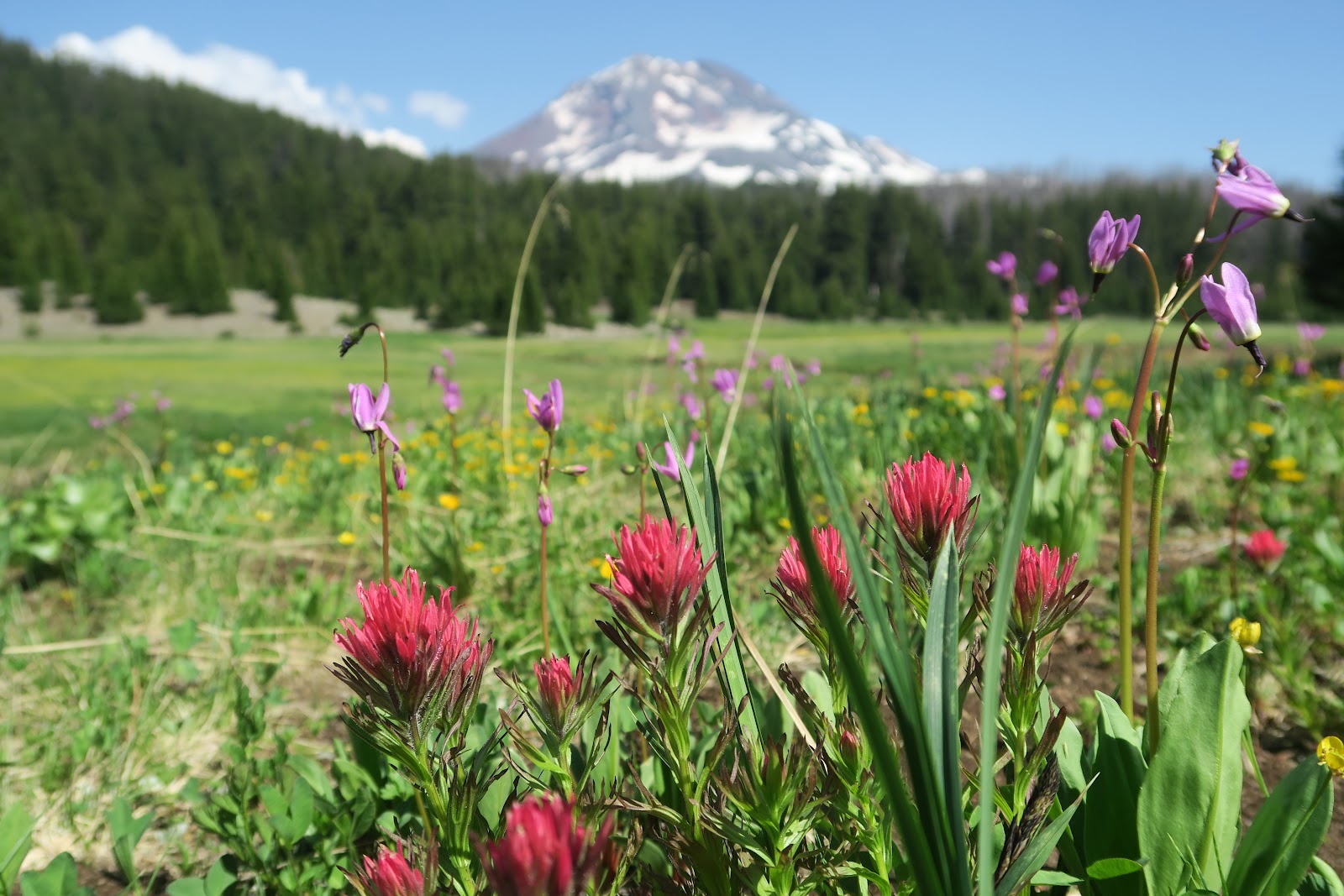
Day3: South of Linton Meadow to Moraine Lake
3rd day was another pretty day. Again, it was view packed. Mesa Creek area had full of colorful flowers. This would be a nice place to camp and spend evening there, but it was like 9 a.m. we were there.
We had snack along the stream. It was a sunny spot. I went behind tree area for the restroom break. Ugh! I got surrounded by 100 mosquitoes immediately, but I had to do my business... such a pain especially for female bathroom break.
 |
The Wife and The Husband
|
Here, I need to mention that there is a viewpoint you can see both The Wife and The Husband. In the left craggy mountain is The Wife. In the distance in the right is The Husband. In this angle, I thought that they want to be closer. Interestingly, when I posted this picture, one person commented that yelling each other. Well, it is your perspective how you interpret this scene.
 |
Wickiup Plain
|
The next area after Mesa Creek wild flower area is Wickiup Plain. Vast pumice. I like hiking pumice a lot, so I enjoyed the area. The view of South Sister is great. During the Wickiup Plain, we left PCT and went east. We met probably about 10-15 PCT hikers: all fast. We talked with a guy and he said he started at Mexico border, but he had to skip Sierra due to record snow. It is certainly a wise choice, but at the same time this year they miss one of the best portion of PCT. Now I am really glad I did John Muir Trail in July on a record snow low year.
 |
Moraine Lake with Broken Top
|
This day we decided to stop early at 1:15 p.m. This is quite unusual for us. We usually hike until at least 5 p.m. The reason is that we planned to hike up to South Sister on the following day. That is a side trip and the side trip trail starts at Moraine Lake. We got a great camping spot at Moraine Lake. At Moraine Lake, backpackers are required to stay at the designated spot. There are about 20 campsites. There is sign indicating a spot. On the way to the Moraine lake, a random backpacker told us site#3 is the best, because #3 can see both South Sister and Broken Top view.
 |
Moraine Lake with South Sister
|
Indeed. The proof is the left two pictures. Above picture has Broken Top view and the below picture has South sister view. Awesome campsite. This is my favorite campsite during the loop. We set up the camp, went down to the beach of the lake and I soaked my legs. Mr.N swam.
We had a very relaxed afternoon.
Day4: Hike to South Sister, then go to Green Lakes
 |
Moraine Lake and Broken Top
|
We got up at 3 a.m. and started hiking up to South Sister. Moraine Lake was very beautiful at the dawn. The sky behind the mountain ridge is orange. 3 a.m. sounds crazy, but there are always crazier people. I saw in the distance in the mountain, two head lamps were moving toward the top. We are not the craziest hikers. Since this can be a day hike, many people would be expected.
 |
On the way up
|
It was amazing to see the first sunlight got showcasing the South Sister as I climb it. Beautiful! After a couple of false summits, we made it to the top area. It was a surreal view that never be able to be seen from the bottom. The big snowfield on the top flat area and the center has a little melt.
 |
summit area
|
Since we started early, the summit area was not so crowded. We took out time to observe the surrounding area. South Sister summit is one of the most beautiful and stunning place I have even been. From the top, you see Middle and North Sisters. What an amazing view! What the view really unique is the pattern of snow patches. The snow white quite highlights on the volcanic color mountains and the pattern is so pretty. Everyday the pattern would be different, so the view on that day is unique to my heart and it ever lasts as my memory.
 |
At the South Sister top
|
We came back to our camp around 1 pm and we packed up and hike to the Green Lakes. It is again a very pretty area. The most stunning view I remember the most is the next morning's South Sister reflection on Green Lake.
 |
Green Lake
|
Day5: Green Lakes to Pole Creek Trailhead
 |
Dead falls
|
The last day was hiking out. After we enjoyed calf beautiful Green lake in the early morning, hiked some open meadows and forest, then did a small side trip to Golden Lake which has a perfect Broken Top view. After Park Meadow, we came back to the area of Pole Creek Fire. Again, hundreds of dead falls. Imagine trail is like left picture for 3 miles. You need to climb over and it slowed one down. Indeed, two people we met Green Lake area, they started at Pole Creek trailhead and their original plan was camp at Green Lake and go back to Pole Creek trailhead. Due to such tedious trail, they said they would hike out south of Green Lake, and try to hitch back to Pole Creek trailhead. They said that we were brave to do whole loop with such trail. We also met a couple with a toddler near the Pole Creek Trail junction where the dead falls were not yet started. They were ambitious: plan to a whole loop with a toddler as eight figure (half way they would resupply). It would be a lot of work ahead for them. I bet they stopped first half of 8 figure.
Overall, I enjoyed an amazing mountain view, interesting volcanic geology, colorful flowers. Loved the three sisters. I someday come back to scramble up to the Middle Sister!

 3rd day was another pretty day. Again, it was view packed. Mesa Creek area had full of colorful flowers. This would be a nice place to camp and spend evening there, but it was like 9 a.m. we were there.
  We had snack along the stream. It was a sunny spot. I went behind tree area for the restroom break. Ugh! I got surrounded by 100 mosquitoes immediately, but I had to do my business... such a pain especially for female bathroom break.