2020-02-04

Tramping (Hiking) in New Zealand #11: Chasm Walk and Milford Sound

The next day after finishing Greenstone and Caples track, our plan was going to the West Coast, but not quite sure if we should go. First, we stopped at the town of Wanaka and had lunch at a restaurant. I had fish and chips, which is one of the signature dishes in New Zealand. They were good. I like fish very much, because I am from an island.

The reason why we were concerned about going to the West coast was weather and road situation. New Zealand weather pattern is: rain comes from West and hit the mountains, then east of mountains are less rainy. There was a week of rain just before we landed on New Zealand on the west coast. It led to a lot of land slides on the west and there was only one road to go to the west from anywhere else in NZ at that time due to road closures. So if something happened there would be a possibility for us to be stuck on the west. 

When we asked a person at the tourist center in Wanaka, she said "Oh I wouldn't go to west" Then she said, "There is Department of Conservation down the street. They might have more information."

We went to the DOC centre and got more information. 

We got information that the road closure was due to 200 mm of rain for 7 consecutive days. It is unlikely to happen very often. Even heavy rain warning we got during Greenstone backpacking was like 70 mm of rain. 

The road closure portion was going to be ended on Dec 25 according to Google map. DOC centre person informed Mr.N, "Don't trust Google map, dear." and told him about the NZ public road information site. According to that, the road was going to open much earlier. With those information, we made a decision to go to the west. 

BEAUTIFUL

Driving out of the Greenstone area there were many breathtaking views. I loved the area. A bunch of falls were coming out from glaciers on the huge rocks were so beautiful. That area is very pretty, but there is not much tracks at least officially: maybe there are. Local must know. 

Then we did a small hike of 20 min: The Chasm Walk


The Chasm Walk

Type: Lollipop

Time Spent: 20 minutes

Distance:  400 meters (0.25 mile)

Elevation change:  neglectable

Ha! I don't usually go walking this type of very short walk, but this was very interesting. You can see a real power of water here. 

patholes

After a lot of rain, the water go flow the river. Because there is so much water with strong current, water picks up pebbles and stones. Then those stones curve the rock. Rocks get a hole. Then more pebbles come to a hole and roll in the hole. The holes are potholes. Patholes are seen in the right picture. Some potholes have small pebbles in side (a picture below)

As you can see in the picture, the current is super strong. There are bridges above the chasm and you can see these from the top. It is very powerful. Also it is very strong sound from this fast current. Wow.

Milford

Lastly, we stopped by Milford Sound on the way to the West coast. Milford is one or the most popular international tourists' destination. Milford has a "Great Walk", however, it is the most expensive Great Walk. First of all you need to take a boat to start Milford Track. Then the hut cost is $140/person/night (no food!). No camping is allowed. Only one direction is allowed to walk, which means that you need a shuttle afterwards. Super expensive. So we decided to do just checking out Lake Te Anau.
Milford sound consists of fiord. There are a number of valleys carved by glaciers. It is interesting to see glaciers and the ocean at the same time. It is indeed a unique view. It used to be all ice up high, so there was no mountains, now those glaciers were melted and valleys appeared. It is pretty and it would be nice to kayak or take a boat tour when I have an opportunity to come back someday. 


2020-02-01

Tramping (Hiking) in New Zealand #10: Bridgestone and Greenstone Backpacking day4

Greenstone and Caples Tracks

Type: Loop

Time Spent: 3 nights 4 days backpacking

Distance:  60 km (37- miles)

Elevation change:  4225 meters (approximately 6800 feet) 


<Day4>

Near the junction of Caples track and Steel Creek track to the trailhead Divide

Plus side trip to Key Summit

14.1 km (8.8 miles),  427 meters (1400 feet) elevation gain

Saddle

This day we started with ascending toward Mckellar saddle. I was expecting much more strenuous climb, but it was easy. I like being in the quiet mountains in the morning. The air was crisp and always mountains are massive. At the saddle I was able to see mountains at 360. 


We ate some snack at the saddle. Those snacks were from New World Market in Queenstown where Izzy lives. Snacks reminded me of Izzy and made me smile more at the pretty place.
Then we descended and headed for Key summit. Key summit is a little side trip, but Julie at Mid Caples hut told us it is really nice and definitely should go. So we left our backpacks at the junction and climbed some for the summit. Without a big backpack was nice even on uphill. 

Key Summit was.....amazing!
Key Summit

360 of mountains. Clouds were rolling in and out continuously, so it was not the same view anytime. This is a good end of the backpacking. You can come to Key Summit as a day hike, too. 

Outdoor toilets

Then we approached to the trailhead. I knew that the trailhead is coming soon, because the stinky smell came.....from the toilets. The moment I smelled it I remembered the moment I started tramping Greenstone backpacking.
New Zealand toilets have system to be not stinky. Sometimes it works sometimes don't. The left picture is the toilets provided by DOC. I saw more than 100 of this type of toilets at campgrounds, trailheads, etc. As you can see there is transparent staff at the top of the chimney like structure. When there is winds, the transparent thing circles. It take the air from inside the toilet and exhale into the air outside. In that way inside the toilet is supposed to be not stinky, IF the lid of the toilet is closed. Some people don't close the lid, so it is very stinky inside. Sometimes 4 toilets are provided side by side and frequently used (meaning frequently lids are left open), even outside gets super stinky. The trailhead for Greenstone backpacking was the example. I always pinched my nose to go to the toilet. I have 10X more sensitive smelling than Mr.N, so it is always hard for the outside crappers. Mr.N had no problem using stinky toilets at all during NZ trip. 

In the evening we went to a free campground where we found on the Wikicamp App. The app indicate that site allows tents, but the park was full of camper vans and there was sign saying no tent. So we went to a nearby private campground. Because it was past 7 p.m. the office was closed, so we put money in the envelope and put in the post. $12/person/night. There is a kitchen area in side the small building with tables, electric stove for cooking, pots, dishes. I was able to charge my camera here. $12 included shower, but there was a code to enter the shower and couldn't get it that night.
In the drizzling morning, I saw the owner went to the office. Then she came to us and said, "Oh sorry your tent was rained. Usually it is not rainy like this." Then she gave us a code for shower. It was funny that she checked the money box first then came to us with being nice.
It was really nice to take a hot shower after backpacking!


2020-01-25

Tramping (Hiking) in New Zealand #9: Bridgestone and Greenstone Backpacking day2-3

Greenstone and Caples Tracks

Type: Loop

Time Spent: 3 nights 4 days backpacking

Distance:  60 km (37- miles)

Elevation change:  4225 meters (approximately 6800 feet) 

<Day3>

Mid Caples Hut to middle to the forest near the junction of Caples track and Steel Creek track 

8 km (5 miles), 81 meters (266 feet) elevation gain


When we arrived at Mid Caples hut at 7 p.m. there were only 3 people at the hut. There was plenty of space. Two guys from Chicago, US. Father (Steve) and son (Dan). A lady from North Island, New Zealand (Julie). They were super nice. 


Then at 8 p.m. another hiker showed up. He is from Tasmania island, Australia (Gary). He was also friendly and chatty. 

Mid Caples hut

Since there were only 4 people at a hut with 24 bunks, everyone used 2 mattresses. It was luxurious. 


Gary snored a little, so I woke up when he snored, but it was fine. Compared to the hut we stayed in Italy during Tour du Mont Blanc, it was nothing. The Italy one was so terrible. 

The heavy rain warning was from 10 p.m., but the rain didn't come until 5 a.m. It started raining and got heavier when everyone woke up around 7:30 a.m. Ha. So all 4 people stayed at hut, kept fire going in the stove by putting coals continuously and chatted. I am not a social person, and in fact sometimes anti-social, but I found those people very nice and friendly and "safe". 

Julie is an avid hiker and she knew a lot about hiking places in New Zealand. Mr.N asked recommendation and got some ideas for the future trips. She is very nice, but her New Zealand English was hard to follow for me as a non-native English speaker. Even Mr.N had a hard time since she spoke very softly.
Gary came to New Zealand without a returning ticket. It seemed that Australians can go to New Zealand without returning tickets. Nice. He is retired, so he has time. He didn't rent a car and he hitchhiked to the trailhead. That's why he started hiking at 4 p.m. and arrived at the hut at 8 p.m. Gary has been to the U.S. 36 years ago and he hiked in Montana to Canada again that time by hitchhiking. He found out I did Mt.Whitney and asked me questions. He tried to hitch hike from Montana to Mt.Whitney, but it was too far to hitchhike that time. 

Steve's another son lives in Boston and we talked about Boston and New England a little bit. He has done "Great Walks" before and informed us basically Great Walk huts are same as this Mid Caples huts.  The price is $141 vs $15, though. 

It was still raining at noon, but Steve and Dan decided to go, because their plan is to go to Mckellar hut.  Soon Julie left for Green stone hut around 1 p.m.  Gary decided to stay at Mid Caples hut for another night. It's nice to have unlimited time. We left around 2 p.m. when the rain stopped. Since we had only 8 km to go with minimal elevation gain, we waited for rain to stop. Everyone was leaving and Gary said "I am attempted to hike, too" but Mr.N said, "You have unlimited time, no need to rush :)"

We left the hut at 2 p.m., so we soon saw people coming to the hut. We chatted that Gary would be happy by having chatting buddies. Actually those two people were second time we saw on the trail. We were hiking the same loop at the opposite direction. It was funny and nice. 

On the contrary of our optimism to find a freedom camp spot, it was hard to find a good place. It was very dense forest all the way and hard to find a flat dry spot. Most places had a lot of roots or moss on the ground. Our concern was it was going to be uphill to the saddle soon and if uphill started it would be unlikely to find a spot. Luckily after extensive search, we found a used campsite. It was very big site 70-80 meters away from trail and it seemed that trail crews used to camp there. We guessed that because a section of trail near the campsite was well maintained: actually all gravel was on the trail and trail edge was dug for the water to flow away from the trail. It must have been a long work, because the well maintained portion was quite long. The campsite has flat dry area with view. It was perfect, because there were falls on the mountain, which showed up only after rain. Also a lot of toutouwai visited us. They were very amusing and cute. 

Falls seen from the campsite

2020-01-23

Tramping (Hiking) in New Zealand #8: Bridgestone and Greenstone Backpacking day2

Greenstone and Caples Tracks

Type: Loop

Time Spent: 3 nights 4 days backpacking

Distance:  60 km (37- miles)

Elevation change:  4225 meters (approximately 6800 feet) 

<Day2>

Mckellar Hut to Mid Caples Hut via Greenstone Hut

37 km (23 miles), 396 meters (1300 feet) elevation gain

hedge hog

This day the hike started in the rain forest. While I was walking peacefully in the quiet forest....oops I almost stepped on the hedgehog! Camouflage. Cute! I stopped and took a picture. He seemed to be surprised as well and he slowly walked into the fern area in the forest. Maybe the trail is easier for them to walk. 

Rain Forest

Early in the morning, the rain forest is very wet and quiet. It was really peaceful. The wet trail didn't make any sound by stepping on, so it was completely quiet. Sometimes birds calls happily. 

toutouwai

Birds. New Zealand has a lot of native birds that can be seen only there. Between 4-6 a.m. is the birds' peak song time. It is literally non-stopping. Some has really high-pitch sounds, some are low, but all are cute songs. This is one of the fun parts of New Zealand forests. My favorite New Zealand bird is toutouwai (South island robin).  The picture is above. Although it is endemic, I was able to see them a lot. They really come close to humans. The reason why they come close is not because they want human food. They are looking for insects and after human step on the trail, usually insects came out. Toutouwai come close to big animals to get insects. They are very cute. Their songs are "toutoutoutoutou" I guess they were named toutouwai due to the songs. 


Bridge
Grass in the meadow

After a while we got out of the forest and saw nice open area. The meadow was pretty. We saw a guy in the distance fishing. Nice area. 

Then there was a swinging bridge. In New Zealand there are many swinging bridge. Some are more sturdy some are really built with minimal requirement. The bridge in the picture above is most frequently encountered bridge. As you might see the sign, it is one person at a time. It swings a lot when you cross. It is scary especially if it is windy. For me as a small person, it really unbalanced when wind comes from side. 

In the meadow area in the valley is actually a private land is there is stock. There are cows on the way at one point. Usually cows on the trail run away to the off-trail, from my experience in California. This time they did run away, but to the way we were going to. Grr. We had to get toward them. They didn't understand we were hiking on the trail. After a while finally cows went to the off-trail and we were able to proceed. We don't want to disturb stock, so it was hard!

Sheep in the field

Compared to cows, sheep was much more cautious and they immediately ran away when they saw a first sign of us in the distance. I took a picture in zoom, but only one picture was possible since sheep can run fast, surprisingly. They are cute.

The day started with clouds but soon it got better. On this day the original plan was just go to Greenstone hut. However, we arrived at the Greenstone hut very early like noon. Since the weather seemed okay, we proceeded more and intended to do freedom camp. Then we met a warden on the trail.
He was cutting some weeds to maintain the trail. He was taking care of three huts. Mckellar, Greenstone, and Mid Caples. Wow. AND he maintains trails. So much work. He was so nice. We gave him hut tickets for Mckellar huts for staying at the previous night. The huts tickets are reused. When we bought hut tickets at the visitor centre, the ranger told us some of the tickets were produced in 1996. Some are a little different design which were produced recently. When we gave the warden the old style tickets, he was very surprised. 

He said, "Wow these are very old. When did you get them?" 

Mr.N replied, "A few days ago at the visitor centre."
He answered, "Oh really."
Then he informed us that there is heavy rain warning that night. The warning was from 10 p.m. that day to 2 p.m. on the next day. So he recommended us to go to Mid Caples hut rather than freedom camp and sleep in  and start hiking late the next day. That made sense, so we continued hiking. In that situation the hike became very long: 37 km. 

He was the warden who was Japanese. I am very glad I saw him in person not only the hand-writing white board. 

Caples River

Despite the fact the heavy rain warning is released, the sky was blue and the view was so beautiful. The trail was along the Caples river. The green grass and mountains are over the river. The water color was greenish blue which was pretty. We saw some deer and some cows on the grass. Nobody was hiking in the section and it was quite nice. 

Chasm

A little before reaching the hut, we saw a chasm. Chasm is a deep and steep wall and the bottom narrow part the water was running. Usually you can see it from the top on the bridge. Because it is so narrow, the strength of water flow is tremendous. The sound of water echoes in the steep wall and says like "GGGGGOOOOOOO" I had never seen chasm anywhere else. Also the color of water was attractively pretty. Massive.

Then we reached the Mid Caples hut at 7 p.m. Loooooong day!

2020-01-21

Tramping (Hiking) in New Zealand #7: Bridgestone and Greenstone Backpacking day1

This day was started with fixing the flat tire problem. 

The Bridgestone opened at 8 a.m., so we arrived at 7:50 a.m. 

Mr.N: Are you open?
A guy: Yes.
Mr.N: We had a flat tire on the rental car.
A guy: Who was driving?
Mr.N: .....me.
A lady: I am recording.
A guy and a lady: Hahahahaha.
Mr.N: I think a new tire is needed.
A guy: You drive long with that.
Mr.N: .......probably.
A lady: they don't last long do they?
They are funny and nice.
New Zealanders are known for being very nice and friendly, and I found that the reputation is very true throughout the trip. 

The tire was kind of torn off, so we were sure we needed a new tire. The brach of Bridgestone near the Queenstown airport didn't have the tire for our car. We went to a nearby branch and got a new tire. 

Then we started a hike! Finally. 

Greenstone and Caples Tracks

Type: Loop

Time Spent: 3 nights 4 days backpacking

Distance:  60 km (37- miles)

Elevation change:  4225 meters (approximately 6800 feet) 

<Day1>
Trailhead (Divide) to Mckellar Hut
9.7 km (6 miles), 350 meter (1150 feet) elevation gain


Rain Forest
Kea

Although it was raining in the morning, but by the time we started hiking it was just a tiny drizzling. Besides, the first portion of the hike was in the rain forest, so rain was not an issue at all. Lucky. Rain forests after rain was shiny and pretty. It was so green. Trees, ferns, water falls, river. There is so much going on with a lot of water. 

Then we saw a noise. Whoa. Kea! Kea is a native New Zealand bird that is endangered. The bird was eating something from the branch. Inside of the wing is very colorful. The Kea continued knocking the tree. The Mauri name of the birds in New Zealand are interesting. For example, Kea's bird song is "ke-a". Another example is a bird like pipipipipi that songs pipipipipi. 

Lake Mckellar
Mckellar Hut

Then the Lake Mckellar appears. Since the blue sky came out, the lake looked nice blue reflecting it. The first day's destination was the end of the lake. After a couple of miles we arrived at Mckellar hut. Since it seemed the rain was gone, we were debating if we would stay at a hut or go beyond a little more for freedom camp. While we were thinking, the small rain came. So we decided to stay at the hut. 

Mckellar hut is located in a beautiful places in front of meadow. Over the meadow there is a tall cool mountains (the left picture). 

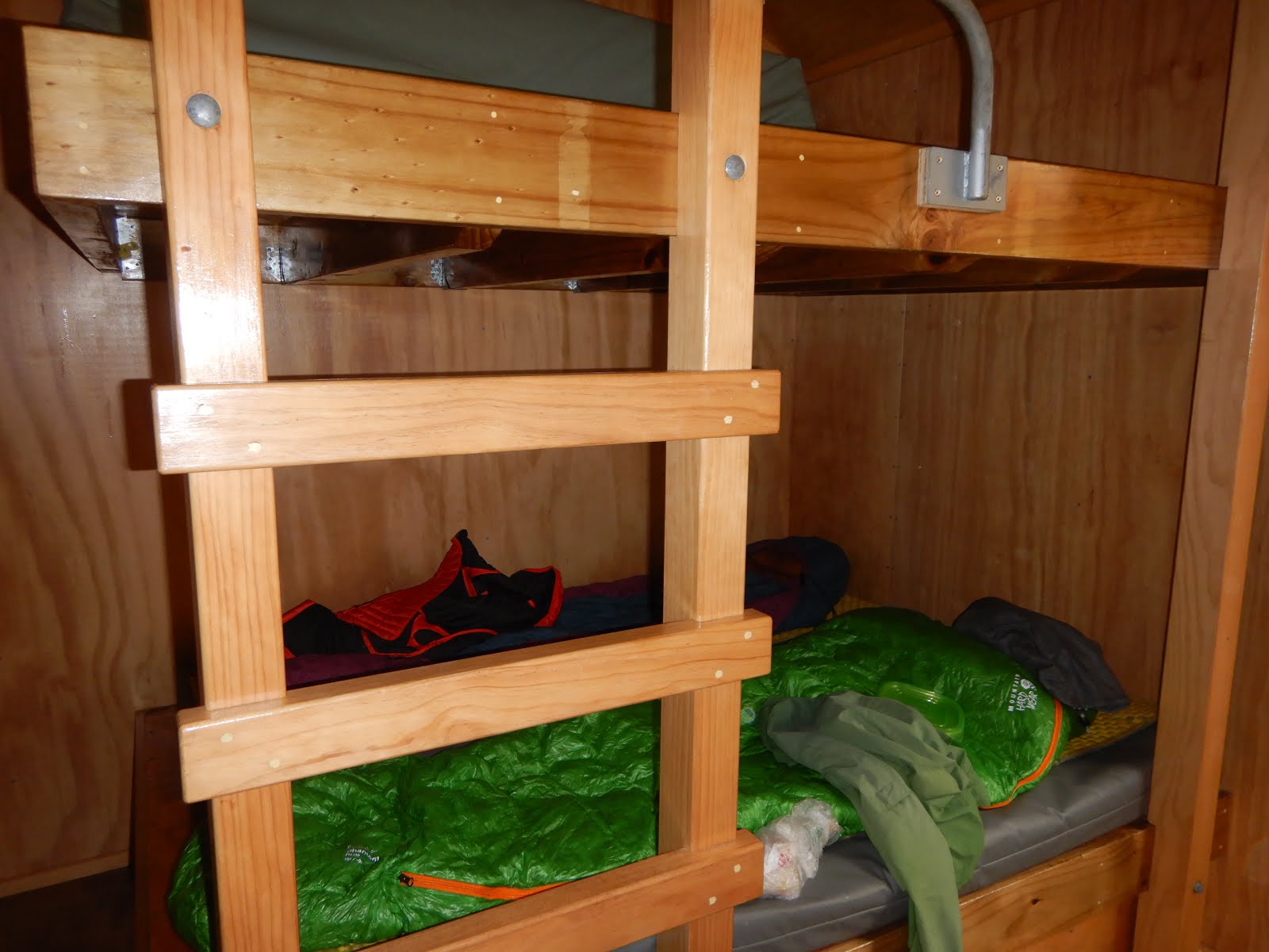
Mckellar hut consists of three rooms. A common room with tables, chairs, kitchen area, and stove with coals. There are two rooms of bunks beds. There is a room for a warden with stove, bunk beds, a desk and a chair, and radio to communicate with a visiter centre.  Near the kitchen area there is a white board and a warden wrote next three day weather forecast. Actually a warden takes care of three huts in the area, and he stayed at a different hut (a hiker at the hut told us). On the white board the warden's name was stated. I saw it and made me happy. The warden is Japanese. It was written as "Eiji Kitai, 北井栄治” his handwriting is clearly by Japanese, so I was sure he is from Japan, not Japanese New Zealander. 

Bunk Bed

Other hikers at the hut were quite international. French, German, Americans, and a hiker from Israel. Some people were doing te araroa (New Zealand's long trail of 3000 km! from north of North island to south of South island).
Bunk beds were nice and there are mattress there. However, Mr.N somehow moved a lot and mattress made squeaky noise all night. I couldn't sleep well.
Next day we got up at 5 a.m. and started hiking at 7 a.m. 

2020-01-19

Tramping (Hiking) in New Zealand #6 IZZY and FLAT TIRE!!!

After hikes in Aoraki/Mount Cook National Park, we headed for the next backpacking. 

Our plan was to backpack 3 night/4 days in dirt track. To check the conditions and get hut tickets, first we went to DOC visitor center in the town. The guy at DOC was very knowledgeable and gave us a lot of information.
Before heading for the trailhead, we first needed to get food and snack for backpacking. So we went to New World Market. New World Market is a grocery store chain similar to Safeway or Market Basket in the U.S.

At the entrance of New World Market in Queenstown, I saw a cute cat!!!!! Her name is "Izzy Cat" Izzy is the first name, Cat is the last name. Izzy is a supermarket cat in Queenstown. She used to be wild, but over the years, she got tamed and now an unofficial employee of New World Market. There is an article posted near the Izzy's shelter and cat tower. You can read the article, "Izzy the supermarket cat" here.  Also there is Izzy's Facebook page even!

Izzy

When I approached the entrance, Izzy was sitting under the bench (you can see the metal bench in the left picture). I sat near Izzy and said, "come here!" and Izzy came to me. She looks happy by being pet. Cute!
Then she sat on the bed and started kneeling.  If I lived in Queenstown, I would come New World every day!!!!!!

I think that Izzy is definitely contributing to the New World's business. A lot of locals love Izzy and people come to see her. Izzy's shelter which has name tag saying "IZZY" was donate by a doting customer. Izzy also has a blanket which also has "IZZY" tag.  Izzy is one of highlights of this trip for sure. 

<Conversation after discussion what the highlights of the trip>

Mr.N: if a cat is a highlight, no need to fly 14 hours. 

K: No. It has to be Izzy. Period.

Well, Okay. So, back to hiking blog. 

After filled our backpacks with snacks from New World Market, we went to the trailhead of Dart Track in Mount Aspiring National Park. The tricky thing of this part is it is a dirt road to the Dart track. This dirt road has small water flowing portion to let water from rain in the mountain go. If it is no rain it is just a small hollow every 10 meters. However, if there is rain during our backpacking, our sedan car might not be able to go through. That means we might be stuck at the parking lot at the trailhead. The ranger at DOC center said 4WD is recommended but not required. Anyway we tried to drive to the trailhead. However, maybe at the third hollow, already it was obvious sedan car can't go through to the trailhead. Being that situation, we decided to go backpacking in the backpack area. Then we started heading back to the paved road portion. On the half way to the pave road, three Asian ladies, clearly Chinese, were standing. One lady tried to talk to us, so we stopped and rolled down the window. The lady was on the right of the car, so talked to the driver (Driving seat is on the right in New Zealand, so is Japan), Mr.N. 

She talked to Mr.N, "We are wondering if it is possible to get a lift to the pave road, 7 km away."
She explained, "Our rental car is not allowed to drive dirt road."
Mr.N said, "Yes we can give you a ride."
Then she saw my face and, "中国語中国語中国語 (Chinese)"
Mr.N: ........... (silence)
Me : ........... (silence)
Me inside: I am not Chinese....I AM NOT CHINESE!!!
Mr.N: She doesn't speak Chinese.

Basically they parked their rented car at the end of pave road and started walking on the dirt road, because their rental company didn't allow renters to drive on a dirt road. They walked 7 km and got tired and no energy to walk back. Apparently they wore normal clothes not hiking wears. Also it seemed they didn't have any water. Because we had a lot of stuff on the back seat, we asked them to hold stuff while they sit in the car. Only one of the three people could speak English. Even that when Mr.N talked to them in English, she didn't understand at all. 

It reminded me of the early days in the U.S. Actually listening is very important. I think that listening skill is more important than speaking. If you don't understand a question, you can't answer, which means there is not even an opportunity to speak. If you don't understand group chat, you don't know what to speak. If you don't follow the conversation, you feel left out. 

While I was thinking about that, we reached at their car. It was 4 WD. Hahaha. Our car was a sedan driving 4WD recommended road.
Then we started driving on the pave road, and got this.

Flat Tire
 Flat tire. 

How many times did I get flat tires during adventures?

1. Yosemite
2. Trinity Alps
3. Death Valley
4. Death Valley (2nd)
5. Big Island, Hawaii
6. This. New Zealand

Now I know how to replace a flat tire with a donut. OK. We went to Queenstown airport and went to a rental car company. The company person told us to go to Bridgestone tomorrow morning since it was already 6 p.m.  

River at the campground

We searched a free camping area run by DOC and camped there. It was a pretty spot. The camping area is right near the beautiful river. 

While we were chilling, 2 rafting person came from upstream and finished at the campground. Wow. Looks adventurous.
Only complaint here was the toilet was stinky! In New Zealand the term toilet is used for the restroom/bathroom in the U.S. I felt good, because the term toilet is used in Japan, too. Another good thing I felt home was left side traffic with driving wheel at the right side. It is same as Japan and I felt so good with that. 


2020-01-17

Tramping (Hiking) in New Zealand #5 Aoraki Mt.Cook National Park : Red Tarns and Off-Trail Beyond, Tasman Glacier Valley Lookout

Red Tarns Track (and beyond)

Type: Out and back

Distance: 3.6 km (2.2 miles) (more if go beyond)

Elevation change: 335 meters (approximately 1099 feet) (more if go beyond)


Optional: you can continue hiking up off-trail

Red Tarns

In the afternoon, we hiked to Red Tarns. This track start at Mount Cook Village. This Village has some hotels and cottages. No campers can stay these and still can hike. 

On this track, again, there are a log of stairs to the tarns. Literally there are continuous steps. The hike starts with crossing river with bridge and immediately the first set of stairs show up. Then, stairs stairs stairs. Very soon the forest part finished and you will go beyond the bush line. There are continuous gorgeous mountain views. Ah. So. Pretty. I felt I was paid off way beyond by coming all the way to New Zealand. Also it was lucky to have two consecutive perfect sunny days in Mount Cook/Aoraki National Park. 

Only thing I realized what I need to be careful on a sunny day in New Zealand is....UV!!!

Usually I don't get a sign of sunburn, such as red skin. I just get tanned color of skin on the next day of hike if I don't put enough sunscreen. On this day I found that my arm where I forgot to put sunscreen was becoming red. Wow. UV is extremely strong in NZ. I heard that there are holes somewhere at south on the ozone layer (near antarctica), and it affects NZ (however, I don't know very well). From this day I put sunscreen everywhere frequently. 

Above Red Tarn

The original destination was Red Tarns, but we saw a hiker going up further from Red Tarns. Not clear, but there was an abandoned or some used trail was seen from Red Tarns. I got interested. I suggested Mr.N going there and he said no. After a break at Red Tarns, I suggested again and Mr.N agreed on going. It is not an official track, but it seems some hardcore people go. If you are good at finding a trail, you will see the track on the right picture. During we climb this portion, a group of 7-8 was descending. It was obviously a guided group: a guide, probably New Zealand local guy, and probably international hikers (they seemed late 60s or 70s: impressive doing unofficial track). 

Mr.N asked a guide guy, "Do you know where this trail go?"
The guy kindly answered, "It doesn't really go anywhere, most people go to tarns at the top, it is really pretty there."
Mr.N thanked, "Great, thank you very much."
The guy replied, "No worries."
He was very friendly and nice. All NZ people said, "no worries" in response to "thank you". During the trip 100%, no exception, people said it.
It is obviously NZ English and I loved it. 

AND....above Red Tarn was amazing. Both me and Mr.N's one of the highlights of the entire NZ trip is this region. It is very secluded, peaceful, and beautiful. 

First, There was a view of Tasman Glacier Valley. One of the greatest spots to see in Mount Cook/Aoraki National park. From that point, nobody was there and we were able to see the view very peacefully. I took off shoes and enjoyed the view by laying down on the grass. Comfy. Priceless!

Tasman Glacier Valley

Pretty Tarn

Also there are many tarns in this meadow area. Snow and glacier mountains over the numerous tarns in the meadow was really pretty.
After we enjoyed the view we came down to the Mount Cook Village and and headed for the final small hike of the day. It is nice to have a long daylight. The sunrise is 5:20 a.m, and the sunset is 9:20 p.m. in December in NZ, meaning a lot of time for hiking. 

Tasman Glacier Lookout

Type: Out and back

Distance: 1-2 km (1.6-3.2 miles) 

Elevation change: 100 meters (approximately 328 feet)


This is a short hike without minimal elevation change. It is very popular for all level of hikers. We came here around 5 p.m., so it was not crowded. Probably normal hikers who don't camp but stay at hotel are already headed out for dinners. 

Tasman Glacier

In this hike now we saw Tasman Glacier Valley close. From the basin above red tarn, we looked way down the Tasman Glacier Valley. It is a different angle. Glacier is massive and cool.  The lake color is grayish because it is very close to glacier. 

Still immense, but the glacier size is rapidly shrinking due to global warming. The place I took picture was all covered with ice before. Sad. The future of NZ glaciers are unknown, but they are shrinking way faster than expected. 

Ball Hut Route (CLOSED: as of 2019 December)

Type: Out and back

Distance: 18 km  (11.2 miles) 

Elevation change: 120 meters (approximately 394 feet)

Leaving Aoraki
Free campsite with full moon
This is the track along the Tasman Lake toward the glacier. We had planned to do as a day hike, but due to 2019 December storm, the track was washed out. Due to this situation, we did all the attractive hikes in Mount Cook/Aoraki in 2 days.We decided to leave this area in the evening and camped in the free camping area from 1 hour away from the Aoraki. Driving near Aoraki National Park was pretty. These are very New Zealand-ish view. Beautiful mountains and pretty meadow with sheep. Cute sheep were resting after dinner. Lucky sheep. 
On this day we luckily found free camping area. Even after sunset around 9:20 p.m., full moon was there and still we didn't need to use headlamps at all.