2024-05-17

Shikes Canyon, Utah

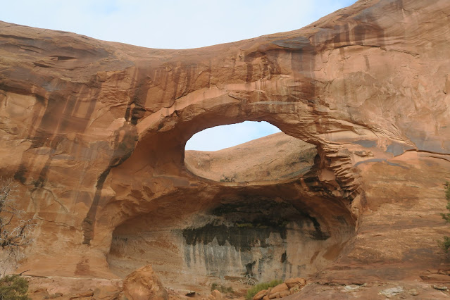
Shikes Canyon is really really exciting! 

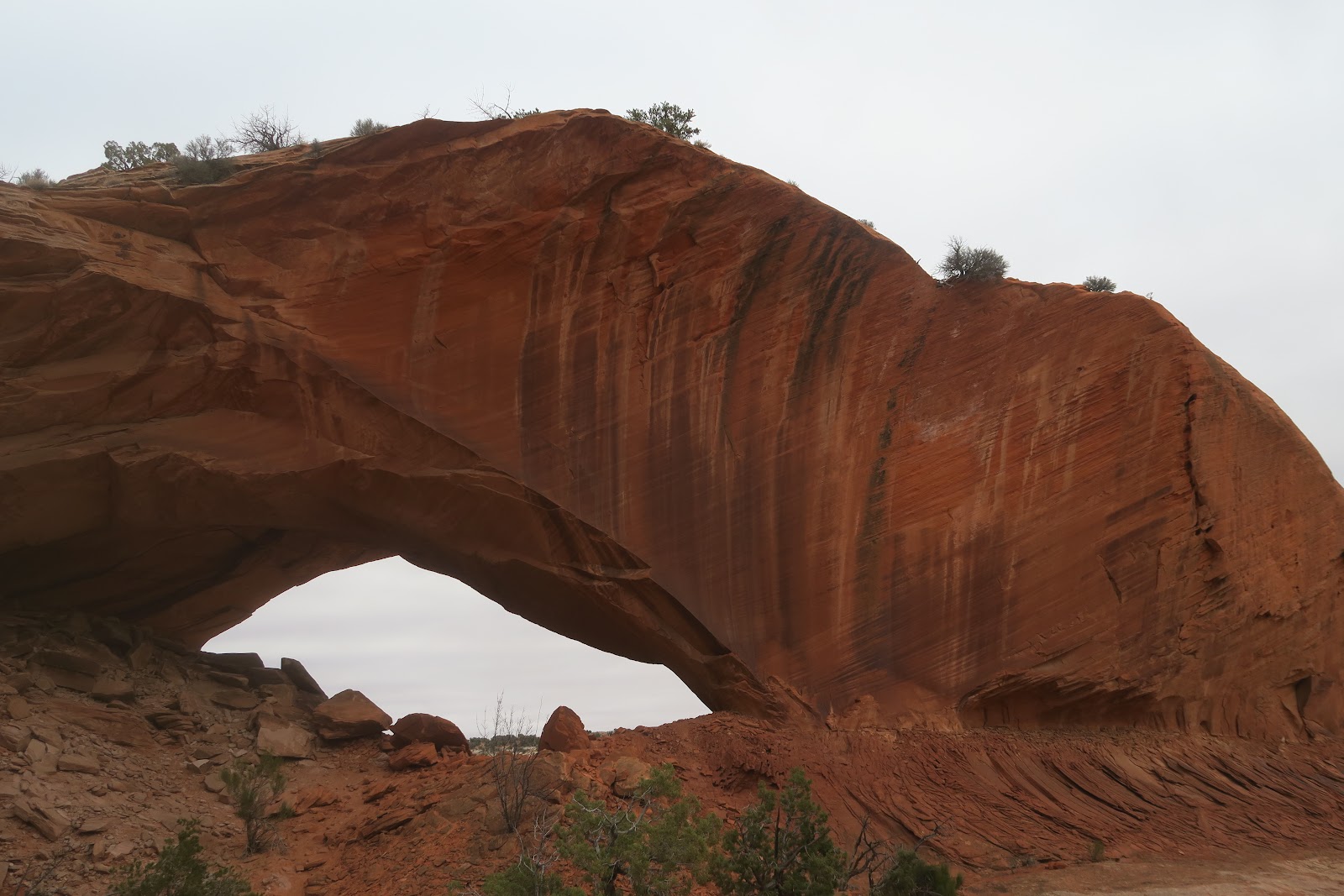
I had been wanting to explore Shikes Canyon for a long time. The reason is because I hiked Kane Gulch and Grand Gulch in December 2021 and knew about Shikes canyon from the map. Shikes canyon is a tributary of Grand Gulch. Since we used Kane Gulch to enter Grand Gulch we didn't have a time to explore Shikes Canyon. Very glad to come back to the Cedar Mesa area and check Shikes Canyon out. I was especially looking forward to observing Green Mask Panel in the Shikes Canyon. It turned out that I enjoyed much more than I had expected. 

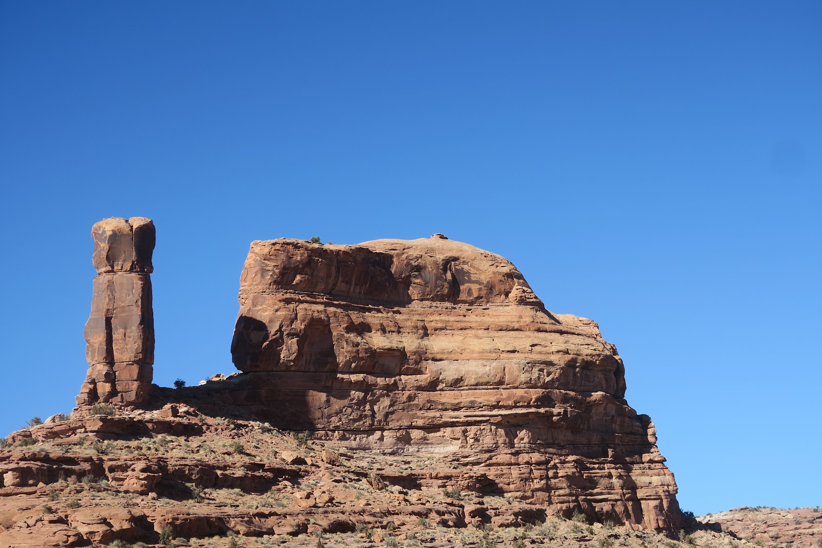
The day before the hike in Shikes canyon we did a dispersed camping in BLM about 30 minutes drive away. It was a very cold morning and the car thermometer indicated at 8F (-13.3C) at the trailhead of Shikes Canyon. It was crispy air and of course no car in the parking area in such a frigid day. 

Nice building
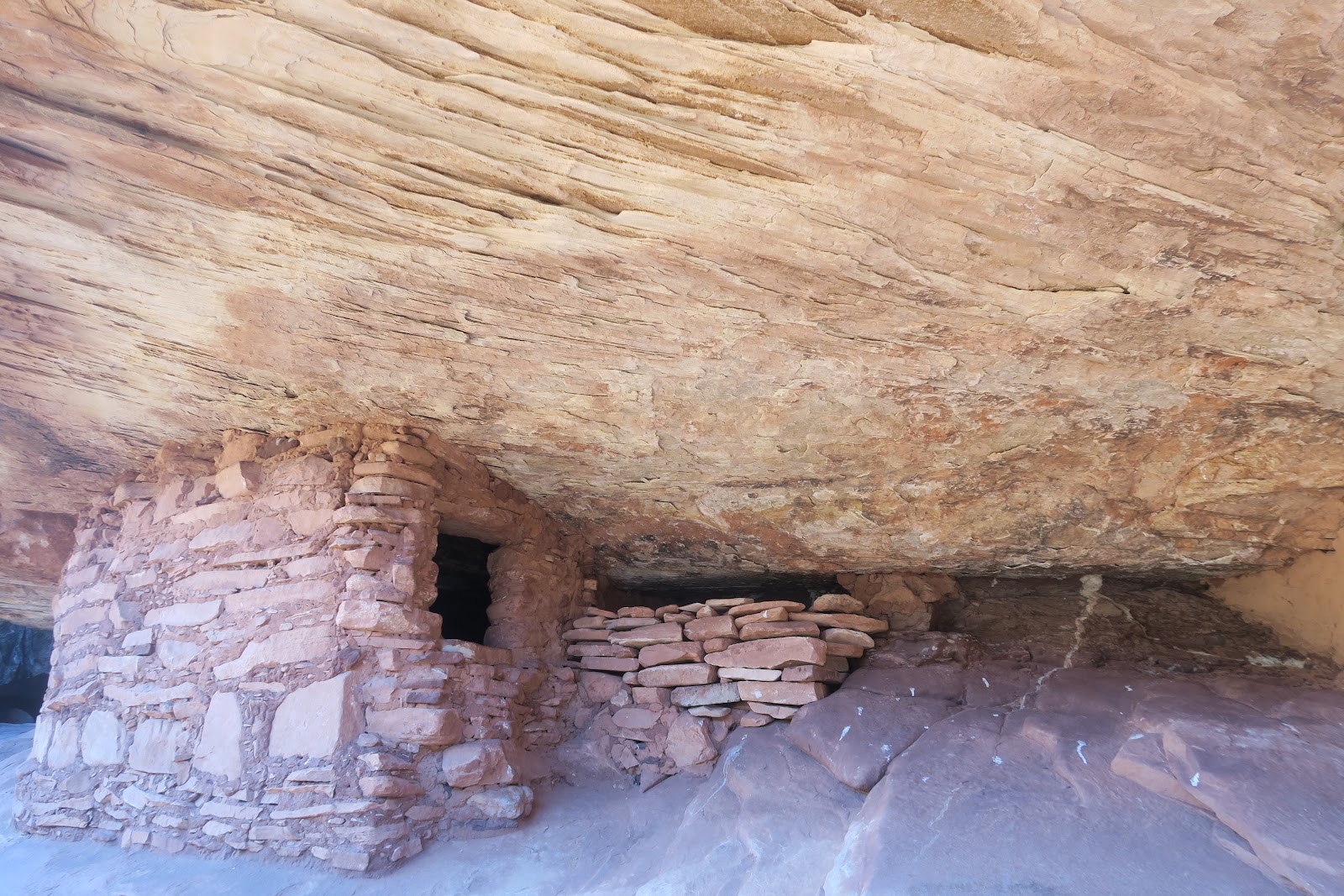
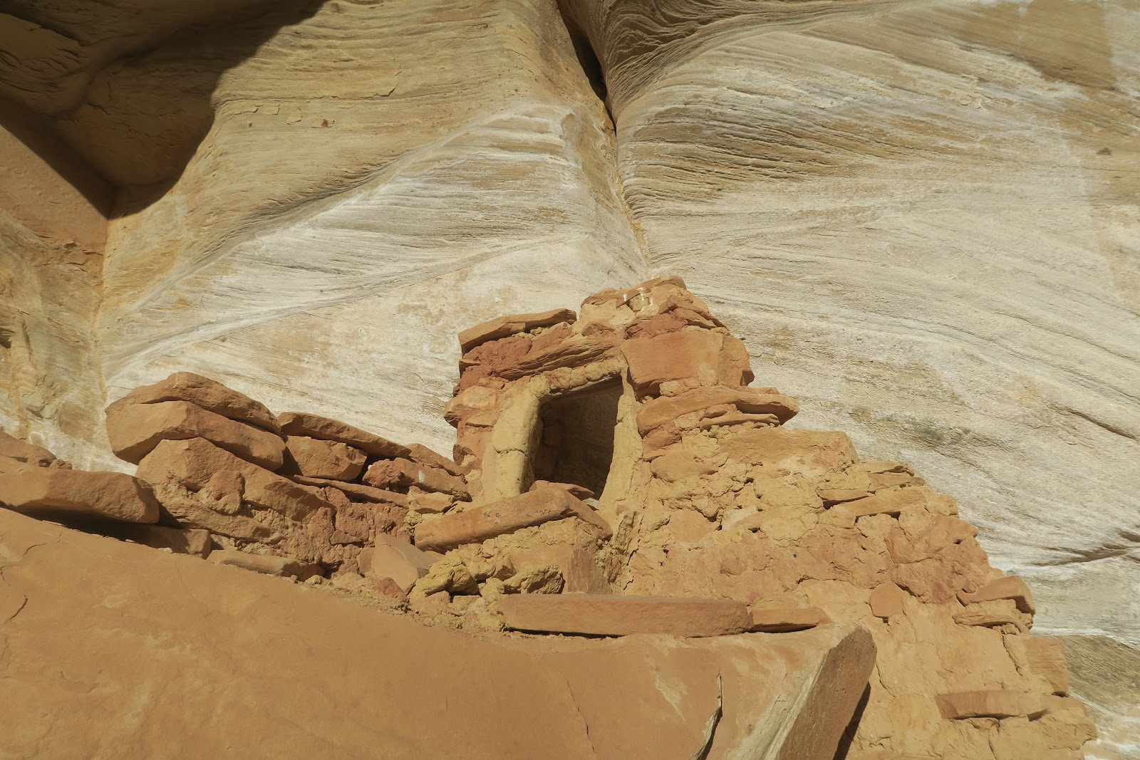
The first attraction we found in the canyon was a neat small ruin. Nice little steps to the entrance. The inside is quite small. I wonder this was a granary or one person bedroom. If it was a bedroom, literally there is only space to lay down. Ceiling is very low. It might be hard to see, but there is a faint rock art above the ruin. It is diamond shape with white color.

Next ruin we spotted was in the distance. Actually really far away in other side of canyon. You have a very good eye if you can find it in the left picture. 


I have a Canon camera that can zoom X17. The left picture is the structure I got with the camera. It is a small structure. It would take an hour to go there and seems not particularly interesting to spend so much time, so we decided to proceed. 


Nice color
The next ruin we found is nicely preserved (left picture). It is under the alcove of off-white color rock. Interestingly, the ruin's bottom part matches the color of alcove. The upper portion is made of more darker color stones. 

Next ruin we spotted was again in the other tributary canyon and very small, so we decided to not go there and proceed. 


The next one is the really impressive one. Green Mask Panel and ruins. The rock art was HUGE!!!
Here some humans without head are painted. The couple (?) drawn by dots are interesting. Each person has boobs (?) with one dot (nipple?).
Small person in the right with filled brown is a kid? No answer but free to imagine.
The left picture is another set of humans without heads. Again one person is a little bigger than the other. I read on the internet that this picture is a C-section birth: some people believe it that way. In that theory, the bigger one is a female. Between two bigger person, there is a small person with small dot that could be a head.
There are many two people drawings. This one looks like having heads. The left one is white color.
Another two people with heads. Interesting head shape. Also there are nipples (?) with another color.
Another two people. One is bigger than the other. 
To me these two people are couple, but who knows?
There is upper level with some ruins, but no way to reach there. I could see the pictoglyph there but not completely. The left is the best picture I could capture. Looks like the same counter-triangle shape humans without head. Color is nicely preserved.
In the right you see many hand stamps. It seems relatively common in Utah. 
Left to
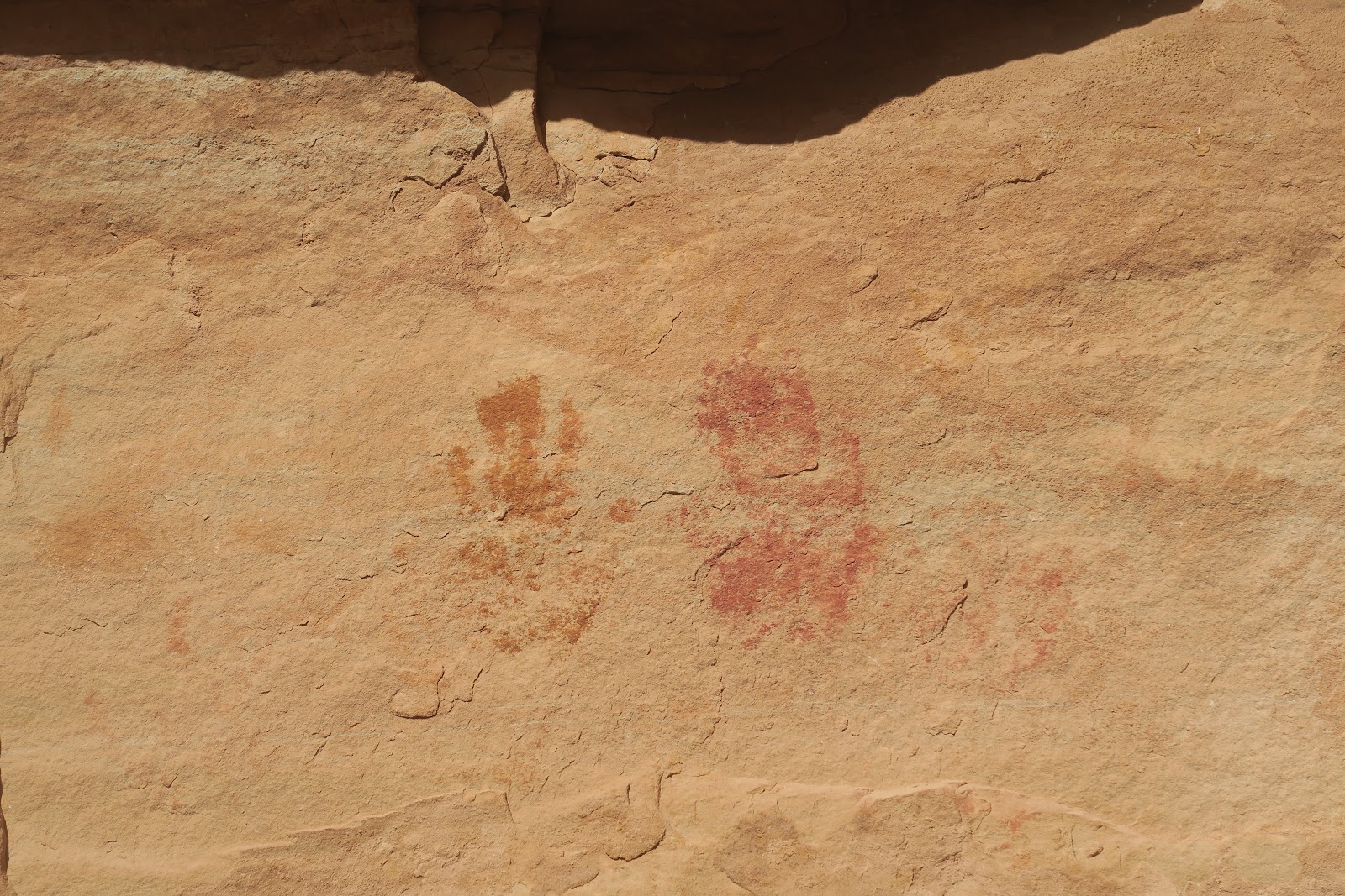
More hand marks.
More of them. 


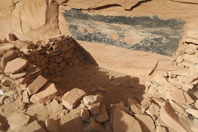
Here is an extremely interesting structure. It looks like a kiva, but not sure. The thing I had never seen was what you seen on the wall. It is painted black in rectangular shape. Then there are 4 circles painted. Zoomed in pictures for the four circles are below.


Left two circles are plain painted.


The right two have circled shape in the circle. 

There must been meaning, but why? Fascinating.


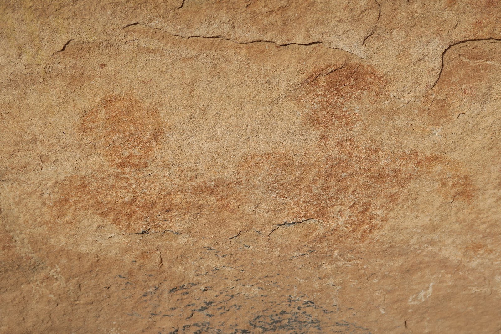
The art you don't want to miss is, Green Mask. The reason why whole art here is called Green Mask Panel. I thought that it looks like a queen. This is my first time I saw this vivid green used for the rock art. Not only green but yellow in the middle was colorful too.


Furthermore, a lot of other drawings are found here as you can see in the above picture. Many colors are used. We spent a fair amount of time here to observe these. Above the wall you can see a lot of brown circles. These are mud balls. It was thought that these circle paint was made by throwing the mud balls. There was some BLM brochure at the site and it was explained that way. Also it said that drawing were made several different time apart. Likely site were occupied for certain time, then empty for while, then again occupied, like that. 

This Green Mask Panel is right before the junction of Shikes Canyon and Grand Gulch. We went to the junction (4 miles from trailhead) and started to trace back. 

 Near the trailhead, we spotted a nice ruin. Somehow we missed when we came in. It was Yellow House Ruin. It consists of several buildings and it is relatively made of yellow-colored rock, that is why I guess called Yellow House Ruin. 


The structure is quite nicely preserved. The roof is impressive. As you can see in the left picture, the lashing is very nicely observed. Neat work. I imagine it would take a lot of time to make these.


Another room is above the first floor. Cool.
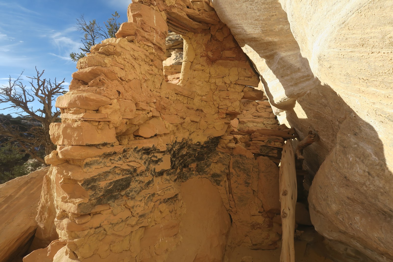
A part of inside is black. Probably fire was used in the room. 

We enjoyed the Yellow House Ruin in the evening light and went back to the trailhead.


2024-05-03

Corona Arch, Bowtie Arch, Pinto Arch

This is a fantastic hike. One hike for three arches! 

This is a very popular hike, because it is close to the city of Moab (actually closest arch from Moab), and it is only 3.8 miles to see all of three arches. It is located in BLM (Bureau of Land Management), not any National Park (Arches National Park), so no need to do entering permit hustle these days needed for a popular National Park visit including nearby Arches National Park. Indeed when Mr.N hiked to Corona arch for some time ago, there were so many people. He remembers that it was not possible to take a picture of Corona arch without people, and the parking lot was full and overflowed. In contrast, this time, there were only a couple of cars in the parking, and we had plenty of time to have the arch ourselves. Firstly because it was in December. Also, it was cold day afternoon after morning snow. I consider it lucky.
Corona Arch


Corona arch is really cool. It is a beautiful round shape as if it was filed. In this hike, you can walk under the Corona Arch and see it from both side, which is nice. The picture above was taken after we went under the arch to the other side.
Bowtie arch and Corona arch
On the way to the Corona arch, there is Bowtie arch as you can see in the above picture in the left side. Obviously you can't walk under the Bowtie arch. The naming is quite convincing. It does look like a bowtie. 
 
 
Pinto Arch

Pinto Arch is another interesting arch to check it out. It almost looks like a bridge (I guess water goes through it), but I'm not a geologist. The hole is above your head. The rounded hall area has nice colored plants. 

Three arch is different and unique, and enjoyed the variety. Very happy to see all the arches in few people around.


2024-04-19

Jeep Arch

 This is a fantastic hike. Jeep Arch (as known as Gold Bar Arch) is quite impressive and the entire route to it is scenic. It is just 4 mile round trip with around 1000 feet elevation gain. 

Jeep Arch is less known compared to the very famous Corona Arch hike in the Moab area, although it is really close each other. It means that you could get more quiet time. We didn't know about Jeep Arch. We learned about it when we got an advertisement brochure from a grocery store in Moab area and it was listed in the Moab area hikes. At first I was not interested due to the name of Jeep Arch. I love any arches, but I thought that the trail is for Jeep (4WD) driving to the arch. There are some 4WD routes in the area. It is not really great to hike when a lot of 4WD driving there. We looked up and found it a hiking foot trail, so we decided to try it. 

Jeep Arch
Jeep Arch

I had never thought that, but after I posted this hike's photographs on Facebook, Ms.H commented that the arch does look like Jeep. Look at the left picture. I think it does! This maybe a reason the nickname is Jeep Arch and the actual name is Gold Bar Arch?

In this hike, the loop actually goes through the Jeep Arch. The picture above is the one about to walk under the arch. The arch shape is unique. Interesting that it is not smooth. From the south side, the snow-capped mountains are seen in the distance. Those are LaSal mountains. What a contrast with desert environment to high alpine area.
Jeep Arch

Then the left picture is the arch view from other side. Cool to see the arch from both side. It was lucky we were able to see the shadow of arch (below picture).
Arch shadow


Spire
The hike is not only for the arch, you see many interesting rocks such as spire in the left picture. You also go under the train track. Also there is a great view of Colorado river. Easy to sink into the beauty of nature in many ways.
Colorado river


2024-04-05

Mule Canyon

Love ruins. 

My first exposure to ruins in the Cedar Mesa in Utah was Kane Gulch and Grand Gulch. Although I had seen ruins in Mesa Verde National Park and Chaco Canyon before that, the Kane Gulch and Grand Gulch experience blew my mind and had an extreme fascinated feeling there. In Cedar Mesa, you can observe ruins closely without barriers or other people (if out of season like we did in freezing December at 10F). It makes me imagine lives of 1000 years ago, makes me feel strange, and feel like their soul still floating around there. Standing near ruins even makes me feel like hearing their voice alive. That interesting and wired feeling is the power of ruins.

This time we explored Mule canyon. Mule canyon is amazing. There are 8 sites of ruins to see. All ruins are very fascinating to observe.

House on Fire


First ruin is very famous and a lot of people hike just for this site called House on Fire. It is only 0.9 mile from the trailhead. It is well preserved and there are 4-5 buildings to be seen. As you can see in the below picture, above the ruin looks like flame. That's why it is called House on Fire ruin.
Another granary(?) in House on Fire
On the day we hiked Mule Canyon was very cold. We didn't see any single person. That made me feel more mysterious to see a bunch of ruins where people had lives once upon a time throughout the year.
Buildings at House on Fire are all nicely remained. It is amazing to see still people can see these. 


2nd site
2nd site is 1.9 mile in. We walked up the canyon, not the wash. Sometimes it is easier to spot the ruin by walking up high. This ruin has two walls and a window. These walls are also quite nicely remained. I don't know other side of walls were collapsed or not there from the beginning. Fun to imagine what was like.
3rd site


3rd site is quite impressive. Multiple buildings are under alcove, but cannot access to it, because cliff is too vertical. I wonder how the people lived here went there. Maybe they had ladder or rope to go there. How could they build multiple buildings in such a difficult access place? It is a nice shelter protected by alcove.

4th site: kiva
4th site, 2.7 miles from the trailhead, is a kiva. It is partly collapsed, but clearly one can tell it a kiva. As you can see in the second picture, a lot of logs are used to make the wall. Beneath logs are more stuck of stones. Also there are windows(?) of square shapes. Logs, stones, and wall of alcove were partly black. Possibly the black came from fire smoke made in the kiva during ceremony. One side of the kiva has a tall building, possible a granary.

kiva, closer look
I can imagine this was quite a work to make kiva here. You would easily notice that there are not many trees around here: wonder how far they had to search to get long logs used for this kiva. 

We wander and wonder around here and continued the hike.
rock art

granary


5th site has a nice shape of granary and a bunch of petroglyph. Circles, bighorn sheep, etc. Also a lot of pieces of pots, bones, and corns are scattered around.
wall ruin

6th ruin, 3.7 mile from the trailhead is wall ruin. This is really unique. As you can see in the left picture ruins are incorporated in the hole of rock and now looks like the flat wall. The second picture might be easier to get a sense how it was built. If you are athletic enough to climb vertically 5 meters, you can have an access to the ruins. With Mr.N's help (he pushed up my butt), I was able to look into the rooms. 

Wall ruin
 

 From outside it is hard to tell how deep the ruins, but once there, you see that there are additional room in deeper side in the ruin. It is really amazing. The most outside room is actually a balcony.

Wall ruin


The left picture is the close look once you climb up to the next level. You look inside from the entry and see another room deeper side. The next picture is the another room inside. It might be a bedroom or maybe closet or granary. Interesting to imagine.
room inside


I was able to climb up the next level, and  surprisingly, there is another upper level for this wall ruin. There is no way to go up the next higher level. I wonder how the Anasazi went up there. The below big picture you can see the next level. When I was observing the structure, I thought that this is like a modern multistory apartment. 
Wall ruin


7th ruin
7th ruin is not very big, but nice to see. It seems to be granary.
7th ruin


entrance
The last site, 8th site, 4 miles from the trailhead, is extremely interesting and quite a big site. First, it is a very hard access but we were able to get there. I searched on the internet, but none of the blogs reached this site. We had to scramble and bushwhack a lot to get to the site. It is only one way to reach there. Importantly, the last part is really narrow to go enter the ruin site. It is a very small narrow flat way with moki step (kind of rock on the entrance is curved so that not to slip off the cliff). Moki steps are found in the area for the very steep rocks in the area from Anasazi era. To enter the bunch of buildings under the alcoves there, you need to go through the entrance door. Apparently, in this way, it made possible to block enemy to come in. To enter you need to pass through the one person narrow ledge. If the enemy comes, the guard just push the enemy off to the cliff away.
whole picture

The left picture was taken just after entered the site. It is a big alcove, and you see many buildings nicely still intact. You might notice that the upper level of alcove has buildings, too. It was too hard to climb up there. Surprisingly, go straight and turn left the end of this alcove in the picture, there are more granaries there on the upper level. This must have been multi family thing. 


rock art
There are multiple rock art found in the site. Below are some representative pictures of it. Very interesting! A lot of hands prints are found there, as well as some animal drawings.


This left picture is the upper level granary (probably).
Ground level buildings. 

Personally this 8th site was the most fascinating site in the South Fork. Many different types of building made by various stuff (stones and motors), a lot of rock art in the multiple levels. It was a challenging access, but that means remote.

Enjoyed so much.


2024-03-22

Zebra Slot and Tunnel Slot, Utah

Two in one.

Going to slots
Zebra and Tunnel slot canyons are seen in one loop hike, total 6.6 miles. From the trailhead along Hole-in-the-Rock road, it is 2.4 mile to the entrance of Zebra slot. The color in the area is really amazing. Pink. I had never seen this kind of color in the nature. It was a really pleasant hike to see this color and geology. Zebra slot was dry when we were there. According to Alltrails' reviews, there could be water depending on a season. Some said the water was up high until waist level. Zebra slot get quickly extremely narrow, so you cannot go much, but really fun. 


Zebra pattern
After Zebra, we headed for the Tunnel slot. This connecting way was my favorite. Actually, there is no trail, mostly route-finding off-trail type travel. I really liked to see a lot of stripes: the reason the slot is called Zebra. Not only the pattern, but the color of pink makes this area very unique. Some rocks has vertical strips, some horizontal, some circles due to how it was eroded I guess.


Water made it smooth!
Another interesting observation one point is in the left picture. The flow of water made the rock smooth. What a powerful force of water. It was cool to see this. 


Tunnel Slot

Then, we reached Tunnel slot. The color is different from Zebra, but another unique colors. More colorful with green, black, brown and pinkish. This is quite short (125 feet/38 meters), and narrow, but not as narrow as Zebra slot. I have also seen this slot could have waist-deep water in Alltrails reviews, but luckily it was completely dry when we were there. As the name indicates, it was dark like tunnel!


2024-03-08

Phipps Arch and Bowington Arch

Two in One hike!

Phipps Arch and Bowington Arch in a day hike. About 10 mile.


Maverick Bridge

This hike starts along highway12. The trail goes along Escalante river, then at the split, go right to go to Phipps Arch. Walk in the Phipps wash. 0.6 mile walk in the wash, there is a side canyon to see Maverick Bridge. Topo map and Alltrail map are both wrong about Maverick bridge location marked. It is easy to tell the location is wrong if you are there, since the location is really over the cliff. It is a small bridge, but you can walk on the bridge and fun. 


Phipps Arch


View from the arch area


Then go back to Phipps Wash and continue the walk. Since Phipps Arch is above the canyon, one needs to go up the side rocks. The arch is not at all seen from the bottom. The last section is scrambling. After several legs and arm work sections, suddenly the arch vision comes in. Phipps Arch is very impressive. It is really thick. It resides at the top of the surrounding canyon like a king. The canyon below the arch is quite nice, too. Indeed 360 view from the arch. 


From other side
You can walk under the arch to see the arch from other side. The left picture is Phipps Arch from the other side. You might be able to see the register box under the arch in the first picture. I signed it for fun. The last person who signed was on the thanksgiving day, which was exactly one month before we did on 2023/12/22. I guess I am the last person at Phipps arch in 2023, because weather forecast was saying it would get much colder after the next day we hiked to Phipps Arch. 
There are a number of round rocks around Phipps Arch as you can see in the left picture. It is interesting to see them. We enjoyed so much Phipps Arch in complete solitude. Then we headed to Bowington Arch by tracing back Phipps Wash. At the split, we went left this time to go to Bowington Arch. First, some more Escalante river trail, then Bowington Arch trail. I don't know these trail names are official, though, because Bowington arch trail is just wash.

Bowington Arch


Bowington Arch is quite impressive, too. Arch is above the dry pour-off and it is dangerous go under the arch, but you can scramble up to just before the arch's bottom. We sat down a little further down to get the best view of arch and had a snack break. During the break, Mr.N said, "I can't find my blue hat since I was at Phipps Arch, but I did very thorough stuff check there" 

For a moment, I was "....", because, THE BLUE HAT was RIGHT BEHIND HIS NECK. 

We traced back to the trailhead. Although several cold Escalante river crossings, this was a great hike. 

After coming back, when I write blog about hike, sometimes I again search the trail on the internet. I found that on the way to the Bowington arch, there is rock art called "43 Men Red Men Panel" Darn, we missed it, but someday I will come back.


2024-02-23

Peek-a-Boo and Spooky Gulch, Utah

 Great slot canyon experience! Really narrow. Narrower than you can imagine. 

3.5 mile loop including both Peek-a-Boo and Spooky Gulch with narrows from Lower Dry Fork trailhead.


Narrows
Lower Dry Fork trailhead is along the Hole-in-the-Rock road (26.2 mile drive of Hole-in-the-Rock road). First part is hiking through narrow. The narrows look narrow? After doing Peek-a-Boo and Spooky Gulch, I consider this is a wide narrows, although the word wise it sounds weird. 
 
Peek-a-Boo Gulch entrance
After this narrows, you will come to the entrance of Peek-a-Boo Gulch. The left picture is the entrance. This entering part is actually most challenging (it is better than the ending is a challenge in my opinion). There is 6 meters (20 feet) nearly vertical climb. Not too bad. There are moki steps and all dry. In the book I read in advance said often pool under the climb and the climbing rock is wet, which is not safe. First Mr.N climbed up. It might be difficult to see in the picture, but rope was left there. Rope is not tied anywhere, so anyway at least one person in the group needs to climb without rope. Once one person is up, next person can use rope (the first person need to hold the rope). Luckily I was able to use the rope thanks to Mr.N. After we both climbed up, a group of 5-6 people (most likely everyone was over 60 years old) came and heard screaming. They were not speaking English, but it was clear saying crazy. We proceeded the gulch, but we never heard they came into the gulch. Since we knew more obstacles would coming in the gulch, we decided not to help or chat too much with them. I judged unsafe for them. 
 
Double Natural Bridge in Peek-a-Boo Gulch

Go under rocks in Spooky Gulch
Right after the first challenge, several challenge continued as I read in the book. We needed both hands and legs and most of the time first threw a daypack to the top, then climbed it so that light body can be pushed up easily. Challenging but it was really FUN!! Also it is really cool to see double natural bridge in the gulch. It is very unusual thing. It was my first time double natural bridge in such a narrow gulch.
It is called Peek-a-Boo, because once go through the bridge, another bridge come into your view. Peek-a-Boo gulch is less than a mile and opens up quickly. 
 
 
Then there is 0.5 mile of open vista walk to the entrance of Spooky Gulch. This is called spooky, because it is dark in general, and one section one needs to go under the rock (I read some books and it might be possible to go over the rocks, though). 


Spooky Gulch

After this challenge, the Spooky gulch gets extremely narrow. There is no way to pass two persons at the same time. Due to that trailhead sign recommend one way loop (Peek-a-Boo to Spooky). I was much easier than Mr.N since I'm a smaller person. While I had fun here, Mr.N said it was exhausting due to narrowness. Daypack needs to be carry in front or side. No space to keep it put on the back. It is same as packed Japanese train. You must not put a pack on the back. The picture with my foot can give you a sense how narrow it is.
foot in Spooky gulch
 
In any way, this is highly recommended hike to experience Grandstaircase-Escalante and slot canyons.