2020-10-31

Mount Hale and Mount Zealand

Mount Hale and Mount Zealand Hike

Distance: 14.4 milesElevation Change: 4121 feetType: Loop with a long spur (Hale Brook Trail-Lend-Hand Trail-Twinway Trail-Zealand Trail-Zealand Road)Summits: Mount Hale (4049 feet) and Mount Zealand (4265 feet)


Recently I decided to hunt all the 4000 footers in New England. If I complete the list I am eligible to buy 4000 footer patches. Actually anybody can buy the patch without showing any proof of completion. It is just how honest to yourself. I want to get a patch as a reward and for my proud. Also it is fun hunting something. 

I love patches, especially for hiking memories. So far I have a patch for John Muir Trail and Tour du Mont Blanc. Why not adding another one? 

New England 4000 footers patches are famous and a lot of people are hiking to complete the list. We even heard that somebody was talking with other hikers at one of the summit of 4000 footers saying even dogs can get a patch. In fact a lot of dogs are hiking for 4000 footers (obviously taken by owners who are doing the list). 

This day we checked off two 4000 footers: Mount Hale and Mount Zealand.
First we started from Hale Brook trail. It was only 2.2 miles to Mount Hale. Although there was no view, we saw 2 cute doggies. The owner said that it was one of the dog's first 4000 footer! Good girl :) The other dog it was the third one. Hardcore dogs.  

Then we continued hiking via Lend-a-Hand trail, which is an interesting name. Now 1500 feet down, then connected with Twinway trail. Again 1500 feet up and reached to the Zealand top. On the way we stopped at the Zealand cliff viewpoint. This was a very good view, and glad we stopped there, because there was no view at the summit.

The rain clouds were approaching. That made the scenery dramatic. 
Zealand Falls

While we were eating lunch at the summit, it started raining. We quickly put rain jackets on and started descending. The worst timing to get rain: the half way point and 5 miles to go. I was hoping that it was a shower not the rain. Luckily after a mile of hike the rain stopped! Clouds went away and blue sky came. This made the Zealand waterfall prettier, since the waterflow drastically increased. We sat down on the rock in front of falls and ate peaches and dried our rain jackets. 

After that it was only downhill via Zealand trail. Although 2 summits had no view, still falls and Zealand cliff was great spots to stop. Finally we concluded the day with sushi from our favorite Japanese supermarket. 

2020-10-18

Welch and Dickey Loop

 In the middle of October, fall color peak is past in northern New Hampshire, and now at the peak in southern New Hampshire. To see more autumn colors, we headed for Welch and Dickey loop, which is in the southern New Hampshire. 

A day before I looked up, "10 Great Fall Color Hikes in New Hampshire" and found Welch and Dickey loop was ranked #1. The description was family hike friendly and short. It was indeed only 4.5 miles, so we were at first a little hesitant. We love a big hike like 10 miles with 3000 feet elevation gain, but the loop is half of our usual hike in terms of both distance and elevation gain. However, we prioritized the fall color and decided to check it out. 


As usual we left Boston at 4 a.m. Since this loop is closer than usual places we went and sunrise time is getting later, it was dark when we arrived at the trailhead. We ate breakfast in the car with small light. By the time we were ready to go, the light came. Perfect. We could have come later, but we were concerned that "family hike friendly" place got really crowded later in the day (in fact, when we finished hike the big parking lot was full). 

trail

sunrise
First portion is in the forest. As we hoped, it was very pretty fall color. It was pleasant to walk under orange and yellow leaves' canopy. Luckily nobody was on the trail and it was very peaceful. After a gentle climb we encounter the first viewpoint. More autumn colors can be seen. Beautiful. There we saw sun just came out from the ridge. I always love sunrise and sunset over the mountains. 

Orange!

Warm orange sunlight now started shining on the orange leaves. That made the mountain scenery more welcoming. It was a color magic. 

One little annoying stuff around here was a guy who had music on. He was at the Welch summit, so we took pictures and carried on hiking. 


After a while I declare here that today I had my favorite fall color view of the year. That is the picture below. The color was magnificent. It was literally like a painting!!! This was a great hike!

Colorful


2020-10-04

Buck Pond Kayaking in Upstate New York

Labor Day is the first Monday of September. Labor day is a holiday in the U.S. to recognize labor movement. Since the Labor Day is always Monday, it will be a 3-day weekend. It is kind of the last good opportunity for summer outing for many people. 

Usually we plan something big trip in summer, sometimes including Labor Day weekend, however this year we didn't have a big summer trip due to COVID-19 pandemic. A little disappointing, so we wanted to plan something for labor day weekend. Of course anytime we can go hiking and backpacking without reservation in New Hampshire, but this time we wanted to have "something" for sure. So we looked up campground reservation over labor day weekend. The only one campground is available for booking on labor day weekend in the entire New England. The only one campground. Wow. We booked it. 

Buckpond campground is located in upstate New York. It is actually very close to Canada. When I searched it on the internet, it seems that the campground is popular not only Americans but also Canadians, especially from Quebec residents. This summer in 2020, US-Canada border is closed for traveling. That seems to be a reason it is less people this year. 

On Saturday before going to the campground we hike up to McKenzie Mountain near the campground. It is nice to hike in upstate New York which has more lakes around, compared to the White Mountain area in New Hampshire. 
Nice Forest
The first 2 miles are relatively flat in the nice forest. On a sunny day, sunlight came through between the trees. I really like sunlight arrived on the dirt. It made the forest more welcoming and warm. The last mile and a half was steep, but good workout. From the summit there are a number of lakes could be seen. Great place to stay for a couple of days to kayak. 
From the top

In the evening we arrived at our campsite and started fun: cooking over the fire. This time we cooked asparagus with lemon, sausages and bell pepper with lemon. Asparagus was an experimental dish and it was not really good, but sausages and lemons were delicious! After we got full, we went to the beach of the lake. It is 3 minute walk from our campsite. 

The evening lake is extremely calm and beautiful. The shadow of mountains are pretty. Oh wow. We discussed the plan that next evening we would paddle here in the evening. Somehow a lot of lakes get calm in the evening with much less winds. It is a great opportunity to paddle at sunset if you don't need to go home after paddling: we had to walk just 3 minutes there!

Looking at the lake in the evening

And........we paddled in the evening at sunset on the next day. It was super peaceful. Evening orange light reflect on the lake. It was very pretty. The trees at the shore also shined orange by receiving orange light and it was reflected on the lake surface. Wow. It was time sensitive and beautiful. Definitely evening kayaking is the highlight of this camping trip!  
After we enjoyed a lot with kayaking, we went back to the campsite and had fun with fire more. 

One downside of our site was the site across the road from our site was noisy. There were 4 people there. It looked like they were friends. 2 Indian guys (from their accents) and a Chinese female and an Indian female. They drank a lot and chatting so loud. It was annoying for people like us to enjoy peaceful night. Quiet time for the campground was 10 p.m. to 7 a.m. Mr.N was planning to tell them once it gets 10 p.m. to be quiet. Luckily they got quiet at 9:50 p.m., but this is one of the cons of car camping. You never know your neighbors are loud or quiet. Of course there are pros: you can cook over the campfire, you can bring a lot of futon and comfy pillow, and as much as jackets. In contrast, in the remote backpacking, it WILL be extremely quiet, but can't be super luxury with nice pillow. 

Mother with fish


Mother giving baby fish

On the third day we paddled again. The highlight of the paddle was a loon and her baby. Although the body size of the baby is identical with mother, the fur color was still brown, which is baby color. The mom is sometimes dive into water and then she found fish. The baby was big enough to learn to dive into water but couldn't find any fish. Every time the baby got out of water, he just cried a lot. It sounded like he was whining to mother that he couldn't catch fish. Then mother with fish swam to baby and gave it to him. The baby looked like satisfied. 


2020-09-26

Mount Waumbek

Last weekend of September. This weekend is surprisingly warm. High is 23C (78F) at the end of September! It might be the last warm weekend of the year. The previous weekend's high was 8C (46F), so it is a pleasant surprise! Especially good for a cold sensitive person like me. 

This warm day we went hiking to Mount Waumbek, New Hampshire. 

Distance: 11.5 km (7.13 miles)
Elevation change: 2749 feet
Type: Out and back
Trail: Killkenny ridge trail

Again as usual we left Boston at 4 a.m. in the dark. Then we ate breakfast at the trailhead and started hiking. Surprisingly we found that already full of fall colors arrived. Yellow yellow yellow. It was like a room of yellow curtain and yellow carpet. This was a very lucky day to be able to see autumn colors with warm temperature. Also I am grateful that here in New England it is safe to hike without wildfires. 


Fall colors!


Trail is simple. No junction until the summit and just uphill. This mountain is a little different from other mountains inthe Whites. The density of trees are a bit lower. Because of that the forest is light and sunshine came throughout the forest. The mourning sun light was warm and shined the yellow color more vivid. It was very pretty. Another nice thing was there were many chipmunks in the forest. They occasionally made noise by climbing trees and dropping acorns, etc. That was really pleasant sounds in the forest. One chipmunk I saw funny was that his both cheek pouches were so full and also having an acorn in his mouth. Greedy chipmunk was cute! 

The view from top was not really perfect because it was very hazy, but I enjoyed the napping on the summit area. The small flat area had full of sun and it was so warm!

One more cute stuff was....doggies. We saw more than 7 dogs hiking on this trail. They were huffing and puffing but looked like they were very happy hiking. I had a chance to pet some of them. Cute!


2020-09-20

Kayaking@Powder Mill Pond

Recently my foot skin was removed (just a small portion), because I exercise at home with barefoot. Obviously the workout was too intense for barefoot. Jumping lunges, jumping squats made the skin removed. It made walk a little hurt. Basically it was similar to having blisters. Due to the situation we went kayaking instead of hiking. 

Powder Mill Pond, Hillsborough County, Southern New Hampshire
Pond and River, Out and Back 
Distance: 7.5 miles
Paddling time: 2.5 hours

Powder Mill. Why Powder Mill? I looked it up, but there was no information on Google. My guess is that there was a powder mill factory or something around there. Now Powder Mill Pond serves public water source, which means water is clean and clear. 

Launching area


There were no many people paddling, actually only a couple of kayakers who were fishing. This pond is more famous for fishing. You maybe able to see a fishing kayak on the above picture. Good thing is that no motorboats were there. Motorboats makes kayakers less peaceful. I prefer calm paddling. Here I enjoyed calm and quiet water. Even more quiet area was the river section connected to the pond. On the river trees were very green and the reflection made the river look like green carpet. It was pretty.  

GREEN!

We started kayaking with another group of fishing kayakers at the same time and we finished at the same time. It was a nice afternoon. 

2020-09-10

Carter Dome Backpacking in New Hampshire

Another 4000 footer in New Hampshire!

Overnight backpacking
Type: loop with a spur
Distance: 11.53 miles (18.6 km)
Elevation Gain: 3,281 feet (1000 meters)

Summit in the loop: Carter Dome (4826 feet high, 1471 meter high)

near trailhead

This time we went backpacking focusing on Carter Dome (4826 feet). Trailhead is on the dirt road near Prospect Farm, near highway16. First we started ascending wildcat river trail. The first portion is in the nice forest. At mile 3.5, there is an unofficial tent site. It is a very big site with a fire ring. Good to know for the future trip. 

Soon after that, we reached the Carter Notch Hut. Of course this summer the hut is closed due to pandemic. However, a caretaker was still there (actually she was on the roof reading a book, nice) and still some snacks were sold. Some bars were at the window and if you want to buy it you can put cash into a bin. 

Owl on the guard


If it was open it looked really cozy hut. There is a main hut building and there is another building for beds. As you can see in the right picture, each small room has 4 bunk beds. It is nice not the giant room with 20 beds, but multiple small rooms with only 4 beds. If your party is 4, it is like a private room. Currently the rooms were locked. Cutely, an owl was guarding!

Carter Dome over the pond

From the hut the Carter Dome looked pretty. The summit is over the pond. As you can imagine, 1600 feet elevation gain in 1 mile.....Steep! Especially with a overnight backpack. Between hut and the top, there is small spur trail to the view. This is a must to check out, because there is not a nice view on the summit, in fact.

pond and the hut down there

The picture in the right is just 0.2 mile from the hut. You can see the huts and pond way down there. Only 0.2 mile of climb. You can tell how steep the trail is. However, it is indeed a nice view: rewarding climb. Here we saw a hiker with a doggy. It was a black pomeranian. Wow. I always thought pomeranian is a spoiled dog always inside where A/C is on in summer. I learned that they can do strenuous hikes on a hot day. 

raspberries

After Carter dome, we descended via Rainbow trail. This trail is not popular, so not well maintained. However we got bonus. A lot of raspberries. Tasty! We ate a lot of them like bears. After rainbow trail we took wild river trail to backcountry campsites, Perkins Notch Tentsite. Tentsite, but just some flat areas with nothing. We had relaxed evening time at the site with campfire.  

The next day we hiked out by only 4 mile walk.
It was a nice weekend. 

2020-08-19

Mount Osceola Hike

Mount Osceola and East Osceola Hike

Distance: 8.18 miles

Elevation Gain: 2871 feet

Type: Out and Back

Peaks: Mount Osceola (4315 feet) and East Osceola Peak (4134 feet)
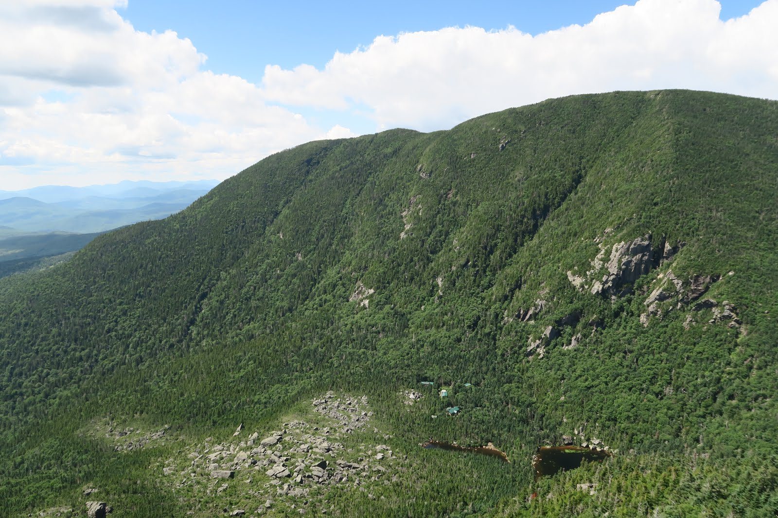
Mount Osceola

To check out more 4000 footer peaks, we hiked up to Mount Osceola. We left (again) at 4 a.m. in Boston and we started hiking at 7 a.m. From the trailhead on Tripoli road via Mount Osceola trail, it is only about 3 miles to reach Mount Osceola. Because it was early in the morning, there were only a couple of people at the top. The view was dramatic. The valley surrounded by Mount Osceola and East Osceola seems somehow a hanging place for clouds. Therefore a line of clouds were there floating above mountain line and it made an unusual scenery. A little breeze sometimes pushed up clouds from the bottom of valley. It was great to see that. 

Then we headed for East Osceola. From Osceola to East peak, first 500 feet down then again 350 feet up. It is mentally hard when I go up and down a lot. Up up up up and down down down down is easier than up down up down up down up down (at least for me). 


Anyway at the top of East Osceola was in the clouds unfortunately. Well it was a good workout. Then we came back to the main Osceola peak. First time we were at the summit was 8:45 a.m. Second time when we came back from East Osceola was 10:30 a.m.  Now more people were at the top. Anyway we sat down and ate lunch and peaches. Two females 10 meters behind us were discussing whether they should go to East peak or not. After a long discussion they decided not to go, because one of them wanted to go to dinner at 5 p.m. in Concord, NH. As you can imagine from this conversation, this trail has many non-hardcore hikers. If you go to only Osceola not East peak, it is just 6 mile hike with 2000 feet elevation gain. Those hikers are not potato couches, but not hardcore either.

Because the past 2 weekends before this hike we had much steeper hikes, both of us though this hike was relatively easy and gentle climb. Bodies seem to adjust very quickly. 

After this good hike, we came home and ate nice Japanese dinner to conclude the day.