The hike starts at Kane Gulch ranger station. In December at -10C (15F), of course the ranger station was closed. Without surprise, there was no car in the parking. Luckily you could park there overnight despite the closure. At the trailhead there is a self-permit pay station: $15/person. The register book indicated that the last person who hiked there was 2 weeks ago. However there were some footprints on the snow clearly, so I was sure not everyone signed. The trail was all snow-covered, but due to foot-prints path was clear.
Because no guarantee of water source, we carried all the water, which was heavy. Well that is the way backpacking in desert. I liked the scenery a lot from the beginning. Massive canyon with snow decoration was pretty. Although it was cold, sun and walk made me keep warm all the time. I love the air quickly warmed up by sun in the desert. Favorite part of West! Absolutely no human around, and the canyon was super peaceful.
 |
kiva at Junction ruin
|
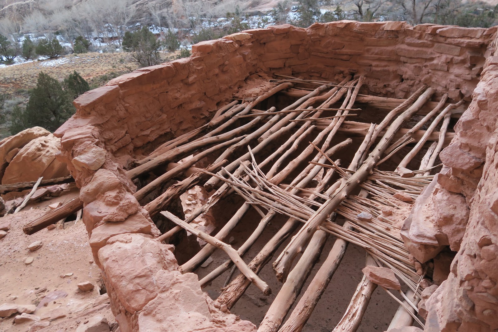
After some miles, we reached the first attraction: Junction ruin. It is called that way because it is at the junction of Kane Gulch and Grand Gulch. Usually ruin is under alcove with several buildings, kiva, granaries, and pictographs.
The right picture is a kiva, where ceremony was held. It is a round shape wall. You could see large log (it is cut) used to be connected to the other side of log. What kind of ceremony was held? When and for what? No way to know, but exciting to see that.
 |
Junction ruin
|
These left pictures are more building under the same alcove. Some are small, so must be granaries, not the living place. We had lunch here and I was imagining how people who lived were feeling. They could have had lunch at the same spot as me. It was amazing that this ruin spot is really warm. I was able to take off down jacket and shoes. Sun directly hits this massive rock and warms up the area. Just one fleece jacket at -10C(15F)?!
 |
Junction ruin
|
I found that in the Kane Gulch/Bullet Canyon, temperature is very different depending on a micro-environment. For example, this Junction ruin micro-environment is one of the warmest spot in the gulch. However when we walk in the dried-up wash with snow, it was super cold and I needed 2 down jackets even while I was walking. Anasazi people must have known every single spot where is cold and warm, and of course they built ruin at warm spots.
Another interesting stuff at ruin is some remnant of their lives. Below pictures are pieces of their pot or bowl. Most are nicely decorated with either painting or carving patters. Also the tool to grind crops are amazing to see still left here. Rocks used for that is so smooth.
 |
At Junction ruin
|
 |
At Junction ruin
|
 |
At Turkey Pen Ruin
|
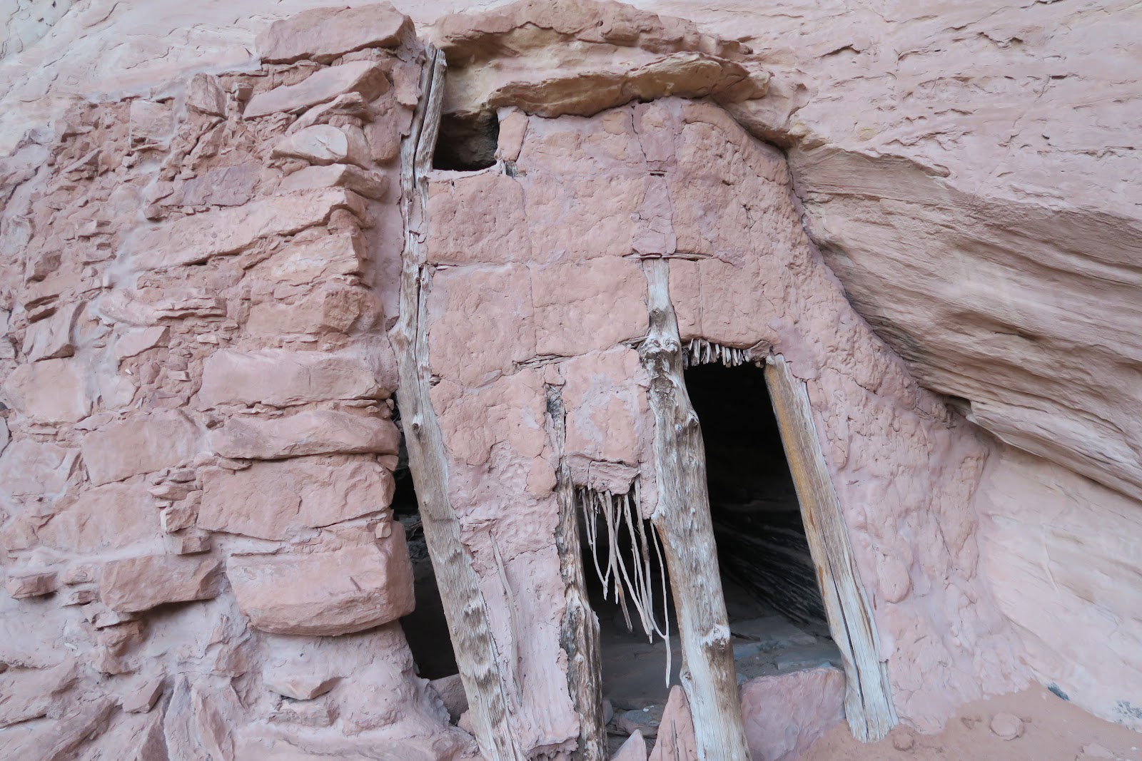
After a nice lunch break, we continued hiking. The footprints were found until Junction ruin, but no more beyond there. It seems some day hikers' destination was the Junction ruin. The trail got much deep in the canyon and sometimes hard to find a path. Then soon after, we reached the next nice ruin. Why it is called that way? The picture left explains it.
 |
At Turkey Pen Ruin |
There are good amount of pictographs at this ruin; some are animals some are human. Some are humans' hand prints. Hand's size are mostly same or slightly bigger than mine. I wonder if everyone in the clan put hand print as a depository.
 |
At Turkey Pen Ruin |
The picture in the right might be granaries. Interestingly, you can see the covering of entrance is still remained. The left small door you can see flat sized rock leaned along. We found a lot of these rock door covering or just along the door. How amazing the exact fit size of flat rocks were used. Or flat rocks were first found and Anasazi people made door to fit the rock?
 |
At Turkey Pen Ruin |
Then another interesting is leftover of their food: corn. Anasazi people farmed corn. The picture in the right is their corns. I was surprised how small their corns were. Each corn is about the size of finger. In the desert it must have been hard to farm as good as now with more technologies. Once when I went to Mesa Verde, the rangers said that most people had a lot of cavities by sugar from corns.
 |
Stimper Arch
|
After the Turkey Pen, an impressive arch showed up in the left. Stimper Arch. Up high with a big hole. Whoa. I love arches. This route has continuous attractions and so much fun.
After that more interesting formation of rocks appeared.
 |
Rock in Kane Gulch
|
 |
Rock in Kane Gulch
|
Junction Ruin and Turkey Pen Ruin are big and most noticeable ruins in Kane Gulch. Most hiking books mention these two and Split Level Ruin (will be mentioned later), but in fact many more smaller ruins and granaries exist along the gulch. Actually a number of ruins/granaries exist in the Cedar Mesa area. One of this is as below picture. Can you see the buildings in the middle of vertical cliff under alcove? We left backpacks and tried to find a way to inspect it close. You can see the backpack was left there. Above backpack point it was too steep to climb up. The point I was taking the picture was the highest I could climb. Sooooooooo, how Anasazi people reached there? They had ladders or ropes to go there? Or they climbed almost vertical cliff? I know in Mesa Verde, people living in cliff dwelling were super good at rock climbing. Maybe here in Anasazi were the same. This might be a granary not living place and this cliff prevent animals from having access to food in the granary. There are a handful of buildings like that where it was inaccessible for hikers (but obviously Anasazi could and even built them).
 |
unnamed ruin
|
 |
zoomed picture
|
And the left picture was zoomed one. It is amazing still the structure was mostly kept. Rocks were stuck together with some clay, and logs were a part of structure. Many holes were probably logs were there before. The buildings were nicely under the "roof" of rock formation. This shape must have protected food or people whatever in the building.
Then after a short walk, we reached the Split Level Ruin. This is my favorite ruin of this trip!!!
 |
Split Level Ruin
|
 |
| roof |
Above picture explained why it is called
Split Level Ruin. It is multiple level ruins with nice door, window and
roof. It is quite a big ruin with many living area, storage area and
activity area. The most low level room in the above picture's roof is in the left picture. The core of roof is made by logs. It was exciting to see such a structure remained. Also it is so much fun exploring and inspecting ruins in the close distance.
 |
Split Level Ruin
|
Left picture is another building of nice entrance. Door is structured with logs. Most of the times when I look inside of these buildings, I found corns. It looked like they ate a lot of corns. I wonder how they ate corns. Just as corns or, made flour? Based on so much grinding stone and smoothed rock area, maybe they made a lot of flour for non-farming season.
 |
Split Level Ruin
|
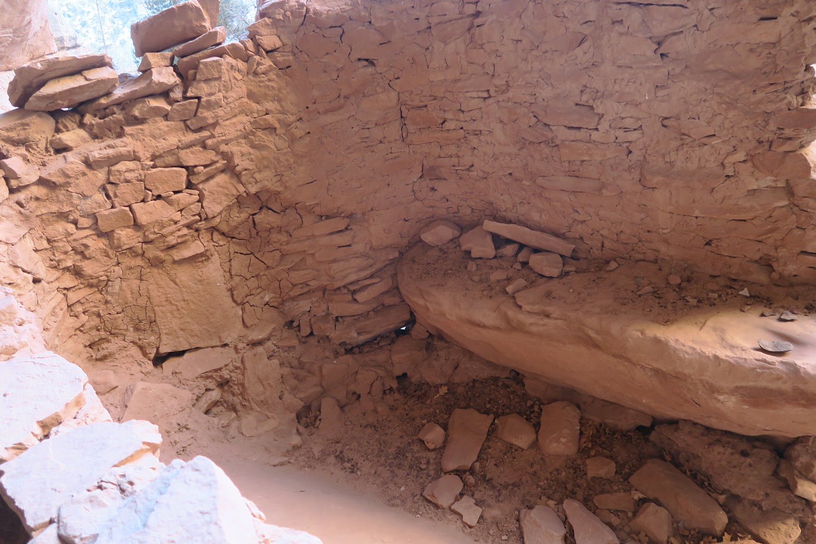
And the left picture, can you see the entrance door blocking rock on the ground? Very flat rock looked like to use close the entrance area. They found flat size rock or they cut?After we explored a lot and enjoyed, it was around 5:30 p.m. Since we found a great flat spot nearby, we decided to camp around. Similar to Junction Ruin, the micro-environment was warm here. Sun hits this alcove and warms up air here, then the warm air sits there all night around here. It was a full moon night, and it was really light even after sunset. I went back to the Split Level Ruin with moon light. It was really pretty and liked it a lot. I felt like Split Level Ruin with moon light is a bit surreal and I even felt like Anasazi people were living there or soul still live there.
Despite the light it was still full of starts visible. For this trip I bought a small toy size tripod and took star pictures.The picture is long-exposure taken is below. Many stars were visible with naked eyes, but with long exposure you realize much more stars are in the sky.
 |
from campsite
|
 |
| Granary |
 |
| Petroglyph |
Next morning we got up at 3 a.m. Because the first day we only hiked 12 miles and day2 would be 18 miles + hitchhike or road walking of 8 miles, we needed to start early. These pictures above were taken when it was still dark. You can tell the photographs were taken with head lamp. It seemed like these were granaries since too small for human to get in.
Hiking in the dark was sometimes interesting. We saw moving shining 4 circles. The circles were moving. If you are a cat lover, you might know cat eyes are shining circles in the dark by reflecting light. We saw those shining circles in Hawaii a lot since there are a lot of feral cats in Hawaiian campgrounds. In this case no feral cats in Cedar Mesa. What animals? Later on we found out they are deer. Obviously deer thought they were hidden. They don't think their eyes are reflecting and making perfect clear 4 circles. When we got closer to them (close enough to see deer body shape by head lamp), they sprinted away.
 |
| granary? |
 |
zoomed in
|
Then, again we saw a granary over the cliff. Can you see in the above picture? You see the granary in the crack of huge rock. Also you see our backpacks on the piles of rock below. It was too steep to climb up to the granary. Also it was too steep and the view of the granary was blocked. So we came to the point where we could see a good view of the building. This point, the sun rose.

 |
nicely made granary
|
For a while of walk, again we found an unnamed ruin site. Some buildings for living (I guess) and a lot of granaries. As you can see in the picture, granaries were built by utilizing rock formation. Front is made with dirt/clay, and the side is pile of rocks.
 |
rock used for cover the entrance
|
Some granaries had a rock to block the entrance.
 |
| inside |
This is inside the building. There is a bench or table. The table had a smooth potion (if you can see): the indication it was used to grind seeds/crops.
 |
Bullet Canyon
|
Soon we finally arrived the confluence and left Kane Gulch and entered Bullet canyon. We realized that 1 night/2 days for 30 miles was too ambitious. If there was nothing to explore, it would be fine, but with so many ruins to see, it was too long. However, we didn't have more food or water to extend the itinerary. Besides we have scheduled itinerary of 2-week trip ahead.
 |
Unnamed ruin in Bullet Canyon
|
In desert it gets quickly warm once sun comes up. It was really nice in the sun in the scenic Bullet Canyon. We had lunch in the warm spot in the Bullet Canyon. The left picture is unnamed ruin in the canyon. This was accessible and we were able to see inside the building. It must be a dwelling for living.
 |
Jail House Ruin
|
Then we spotted big pictograph! Jail House Ruin. This is my favorite ruin in the Bullet Canyon. One is white filled circle, and the middle is white circle with two eyes(?), and the right is with stripes. Is this a mark of clan? These are quite big and will be recognized in far away. You will never miss it.
We hiked up a hill to check it out the ruin.
 |
Jail House Ruin
|
The reason why it is called Jail House Ruin is because of this window. Amazing that the window structure with logs are still here like this. Inside the Jail House ruin has another room. Very interesting. In front of another room is a bed? It is nice flat and looks comfy.
 |
| Inside |
According to the map, there is Jail House spring, but we didn't see any hint of water around. Glad we had all the water carried.
After Jail House Ruin, it was supposed to have another big ruin (Perfect Kiva Ruin), but we somehow missed it (bummer).
Then here was a problem. Towards the end of Bullet Canyon, there was a class III scramble part. It is no problem in summer, but winter, OMG it was all icy. How could we scramble up on the ice? We first thought about going all the way back which was 25 miles almost, but we decided to try.
If you slip, you will really fall to the canyon. We had to carefully assess the safest tiny spot, then crack down the ice not to slip. This was extremely scary. I put my camera inside the backpack to be safe (usually it is outside pocket): so no pictures here. After 1 hour of tackle, we finally passed this dangerous spot.
Finally at the sunset we reached the trailhead. We were tired but still not reached the car. Of course no car at the trailhead. First 2 miles was on the dirt road to go to the paved road. Then 6 miles to the trailhead we started. We hoped to see a car pass by to hitch, but absolutely no car. 1 mile, 2 mile, 3 mile, NO CAR AT ALL. At 4 miles, there was Fedex truck passed but on the opposite lane. At 5 mile, pickup truck passed but again on the opposite lane. At 6 mile, finally arrived at the ranger station. This day we hiked from 3 a.m. to 8 p.m. After 17 hours of wet feet, it was nice to be in the car with heat....The car's thermometer said 10F (-12C).
It was a real hardcore backpacking, and also very exciting. I loved to see countless ruins that were kept intact for long time. It was really nice to explore them in close without anybody around. This was awesome!!!


No comments:
Post a Comment